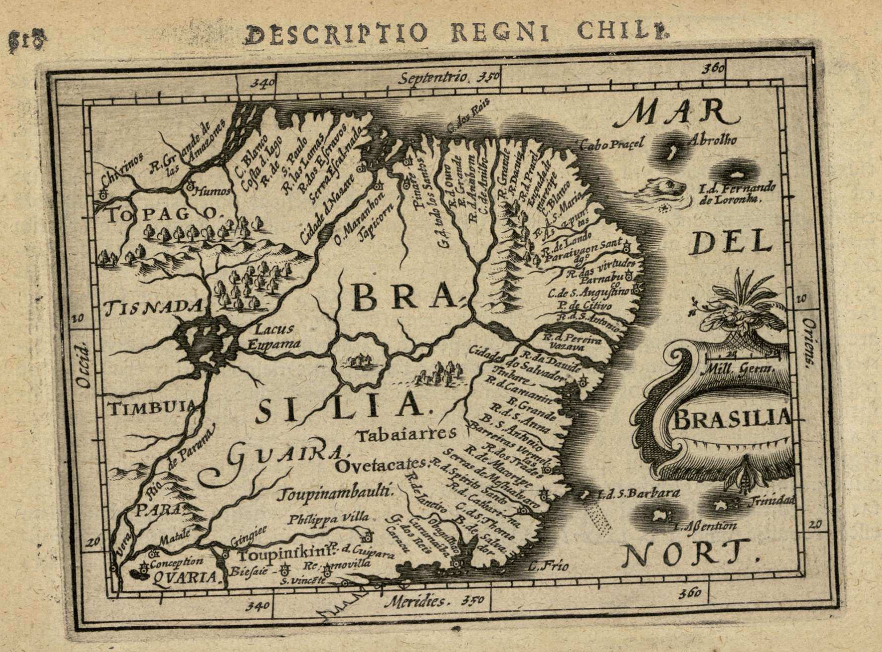
Dispossesions in the Americas

Dispossesions in the Americas

  • Inicio
  • Explorar
  • Autores
  • Sobre
  • Arte
  • Cuerpos
  • Planes de Estudio
  • Herencia Cultural
  • Mapas
  • Territorios
Volver a Explorar

Leyendo en Inglés

Mapa 1600 - 1699

BRASILIA

  • BERTIUS, PETRUS

Publicado: 1616

  • Descargar Imágen
  • Descargar Imágen
Mapa 1600 - 1699

BRASILIA

  • BERTIUS, PETRUS

Publicado: 1616

  • Descargar Imágen

Pueblos

  • TABAIARRES
  • OVETACATES
  • TOUPINAMBAULTI
  • TOUPINIKINI

Citas

Bertius, Petrus. "Brasilia." Map. In Tabularum Geographicarum contractarum Libri septem, 818. Amsterdam: Jodocus Hondius, n.d. Accessed July 18, 2023. http://bdh.bne.es/bnesearch/detalle/bdh0000001447.

  • Descargar Imágen

Artículos Relacionados

Government map of Nicaragua : from the latest surveys ordered by President Patricio Rivas and Genl. William Walker ;executed under the supervision of the Señor Fermín Ferrer;Governor of the Western Department;1856

Government map of Nicaragua : from the latest surveys ordered by President Patricio Rivas and Genl. William Walker ;executed under the supervision of the Señor Fermín Ferrer;Governor of the Western Department;1856

Mapa 1800 - 1856
SKETCH MAP OF THE MISSIONS OF THE CATALONIAN CAPUCHINS IN THE SPANISH PROVINCE OF GUAYANA ABOUT 1771

SKETCH MAP OF THE MISSIONS OF THE CATALONIAN CAPUCHINS IN THE SPANISH PROVINCE OF GUAYANA ABOUT 1771

Mapa 1771
Fig. 1. Map of French Guiana with locations of the various Amerindian groups

Fig. 1. Map of French Guiana with locations of the various Amerindian groups

Mapa 1999
Mapa Original de la Republica Argentina y Estados Adyacentes Comprendiendo Las Republicas Chile, Paraguay y Uruguay

Mapa Original de la Republica Argentina y Estados Adyacentes Comprendiendo Las Republicas Chile, Paraguay y Uruguay

Mapa 1875
Carta topographica de todo o terrero comprehendido desde a Barra do Rio Grande de S. Pedro, the Castilias pequeno, que corre entre aCosta do Mar e a Lagoa de Merim

Carta topographica de todo o terrero comprehendido desde a Barra do Rio Grande de S. Pedro, the Castilias pequeno, que corre entre aCosta do Mar e a Lagoa de Merim

Mapa 1737
NOVA ET EXACTA DELINEATIO AMERICA

NOVA ET EXACTA DELINEATIO AMERICA

Mapa 1534
Carte d'une partie de l'isthme du Darien (Etats-Unis de Colombie) avec le tracé du Canal Interocéanique / par Lucien de Puydt, Ingénieur, Explorateur de l'isthme du Darien

Carte d'une partie de l'isthme du Darien (Etats-Unis de Colombie) avec le tracé du Canal Interocéanique / par Lucien de Puydt, Ingénieur, Explorateur de l'isthme du Darien

Mapa 1875
Location of Nahuat Area on Gulf Coast Plain

Location of Nahuat Area on Gulf Coast Plain

Mapa 1969

Despojos en las Américas

Un Proyecto de

University of Pennsylvania

Copyright 2024

Con el apoyo de

Mellon Foundation

Diseño y Desarrollo del Sitio

Element 84

Créditos Artísticos

Bertius, Petrus. “Brasilia.” Map. In Tabularum Geographicarum contractarum Libri septem, 818. Amsterdam: Jodocus Hondius, n.d. Accessed July 18, 2023. http://bdh.bne.es/bnesearch/detalle/bdh0000001447.

Páginas del Sitio

  • Inicio
  • Explorar
  • Autores
  • Sobre
  • Arte
  • Cuerpos
  • Planes de Estudio
  • Herencia Cultural
  • Mapas
  • Territorios