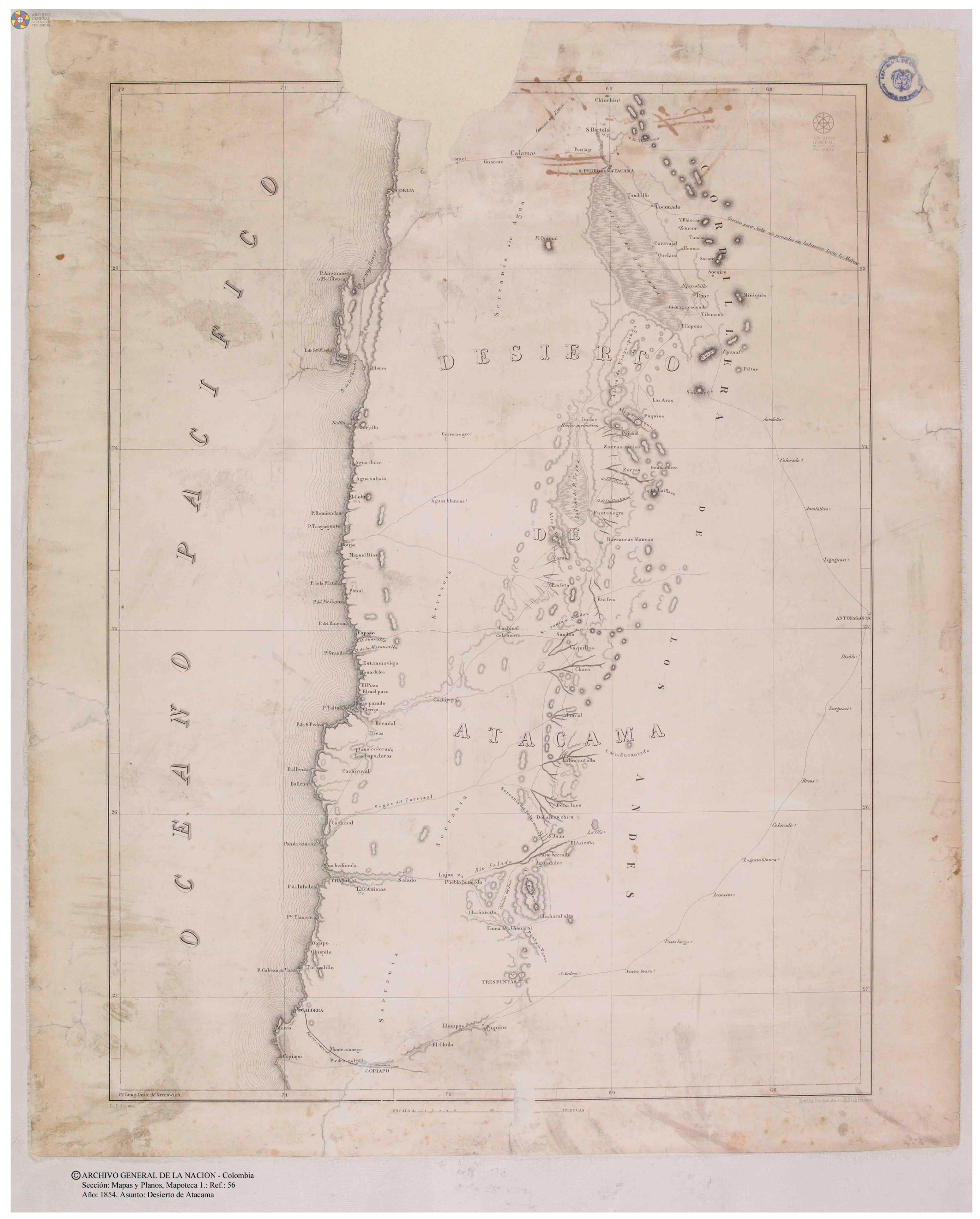
Dispossesions in the Americas

Dispossesions in the Americas

  • Inicio
  • Explorar
  • Autores
  • Sobre
  • Arte
  • Cuerpos
  • Planes de Estudio
  • Herencia Cultural
  • Mapas
  • Territorios
Volver a Explorar

Leyendo en Inglés

Mapa 1873

PROVINCIA DE SANTA CRUZ

  • MACHADO, ANTONIO CANDIDO DA CRUZ

Publicado: 1875

  • Descargar Imágen
  • Descargar Imágen
Mapa 1873

PROVINCIA DE SANTA CRUZ

  • MACHADO, ANTONIO CANDIDO DA CRUZ

Publicado: 1875

  • Descargar Imágen

Pueblos

  • NACKNENUKS
  • GIPOROKS
  • POTE
  • POJICHA
  • URUFU
  • BOKUES
  • PORKONE BATATA

Citas

Machado, Antonio Cãndido da Cruz. Provincia de Santa Cruz. Map. Rio de Janeiro: Lith. do Archivo Militar, 1875. Accessed July 18, 2023. http://bdh.bne.es/bnesearch/detalle/bdh0000018667.

  • Descargar Imágen

Artículos Relacionados

PIANO DELL'ALTO PARANA da S. Anna al fiume Iguazu

PIANO DELL'ALTO PARANA da S. Anna al fiume Iguazu

Mapa 1884
Map of the basin of La Plata : based upon the results of the expedition under the command of Thos. J. Page;U.S. Navy;in the years 1853;-'54;-'55;& 56 and of the adjacent countries

Map of the basin of La Plata : based upon the results of the expedition under the command of Thos. J. Page;U.S. Navy;in the years 1853;-'54;-'55;& 56 and of the adjacent countries

Mapa 1853 - 1856
Tabula Geographica nova Omnium oculis exibens et proponens Venssimam descriptionem potentissimi et aurifen Regni Guiana Sub linea aequinoctiuli iner Brasiliam et eru Situ per nautam aliquem qui Gualthero Ralegh navigatione Semper Adsuit delineata

Tabula Geographica nova Omnium oculis exibens et proponens Venssimam descriptionem potentissimi et aurifen Regni Guiana Sub linea aequinoctiuli iner Brasiliam et eru Situ per nautam aliquem qui Gualthero Ralegh navigatione Semper Adsuit delineata

Mapa 1594 - 1596
BRAZIL

BRAZIL

Mapa 1846
Carta del curso del Orinoco desde la Embocadura del Rio Sinaruco hasta la Angostura

Carta del curso del Orinoco desde la Embocadura del Rio Sinaruco hasta la Angostura

Mapa 1800
Principales grupos indígenas cuando ocurrió el contacto con los españoles

Principales grupos indígenas cuando ocurrió el contacto con los españoles

Mapa 1530
PLANO DEL HATO DEL TAMBO;ADJUNTO A LA ESCRITURA DE DONACIÓN QUE OTORGA PABLO CHIRIBOGA A FAVOR DE LOS INDÍGENAS DE PAPALLACTA

PLANO DEL HATO DEL TAMBO;ADJUNTO A LA ESCRITURA DE DONACIÓN QUE OTORGA PABLO CHIRIBOGA A FAVOR DE LOS INDÍGENAS DE PAPALLACTA

Mapa 1903
EL SEÑORÍO  AYMARA DE LOS SURAS: COLONIAS DE SURA BAJO EL DOMINIO INCA EN EL SIGLO XVI

EL SEÑORÍO AYMARA DE LOS SURAS: COLONIAS DE SURA BAJO EL DOMINIO INCA EN EL SIGLO XVI

Mapa 1500 - 1599

Despojos en las Américas

Un Proyecto de

University of Pennsylvania

Copyright 2024

Con el apoyo de

Mellon Foundation

Diseño y Desarrollo del Sitio

Element 84

Créditos Artísticos

Machado, Antonio Cãndido da Cruz. Provincia de Santa Cruz. Map. Rio de Janeiro: Lith. do Archivo Militar, 1875. Accessed July 18, 2023. http://bdh.bne.es/bnesearch/detalle/bdh0000018667.

Páginas del Sitio

  • Inicio
  • Explorar
  • Autores
  • Sobre
  • Arte
  • Cuerpos
  • Planes de Estudio
  • Herencia Cultural
  • Mapas
  • Territorios