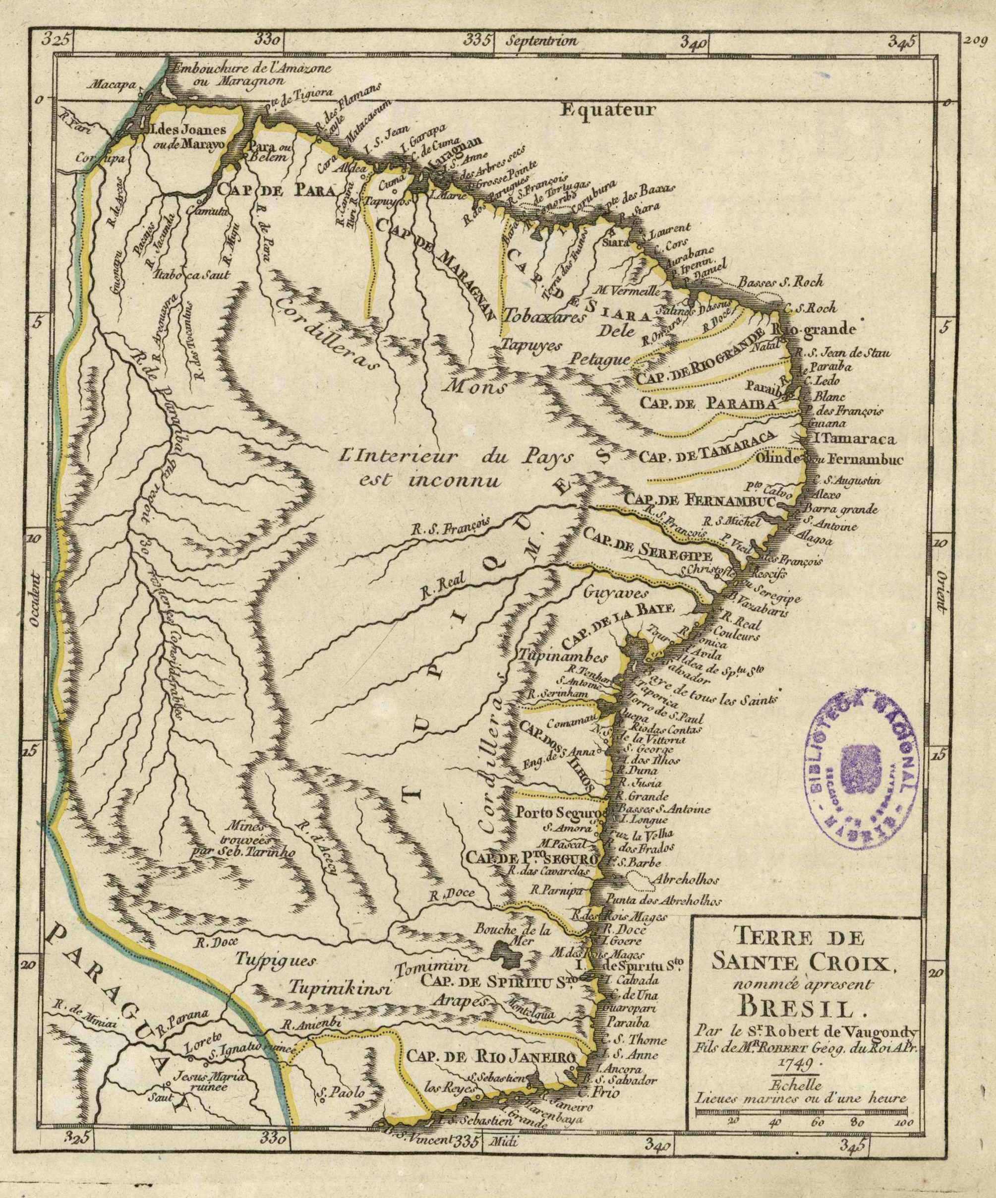
Dispossesions in the Americas

Dispossesions in the Americas

  • Inicio
  • Explorar
  • Autores
  • Sobre
  • Arte
  • Cuerpos
  • Planes de Estudio
  • Herencia Cultural
  • Mapas
  • Territorios
Volver a Explorar

Leyendo en Inglés

Mapa 1749

Terre de Sainte Croix, nommée apresent Bresil

  • DE VAUGONDY, ROBERT

Publicado: 1749

  • Descargar Imágen
  • Descargar Imágen
Mapa 1749

Terre de Sainte Croix, nommée apresent Bresil

  • DE VAUGONDY, ROBERT

Publicado: 1749

  • Descargar Imágen

Pueblos

  • TUPINIKINSI
  • TUPIGUES
  • TOMIMIVI
  • ARAPES
  • TUPINAMBES
  • GUYAVES
  • PETAGUE
  • TAPUYES
  • TOBAXARES
  • TAPUYOS

Citas

de Vaugondy, Robert. "Terre de Sainte Croix, nommée apresent Bresil." Map. In Atlas Portatif Universel et Militaire, Composé d'après les meilleures Cartes, tant gravées que manuscrites, by Robert de Vaugondy, Durand, and Pissot. Paris: Robert de Vaugondy, 1749. Accessed July 14, 2023. http://bdh.bne.es/bnesearch/detalle/bdh0000001597.

  • Descargar Imágen

Artículos Relacionados

Map of Nicaragua showing departmental divisionsand projected routes of interoceanic communication.

Map of Nicaragua showing departmental divisionsand projected routes of interoceanic communication.

Mapa 1851
LOCALIZACION GEOGRAFICA DE LAS COMUNIDADES CIMARRONAS EN COLOMBIA DURANTE LOS SIGLOS XVIII, XIX Y XX

LOCALIZACION GEOGRAFICA DE LAS COMUNIDADES CIMARRONAS EN COLOMBIA DURANTE LOS SIGLOS XVIII, XIX Y XX

Mapa 1700 - 1999
REGIÓN MAYA

REGIÓN MAYA

Mapa 2000
PINTURA DE GUEGUETLAN

PINTURA DE GUEGUETLAN

Mapa 1500 - 1599
Carte 8: Les ethnies amérindiennes dans l'est des Guyanes (1650-1750)

Carte 8: Les ethnies amérindiennes dans l'est des Guyanes (1650-1750)

Mapa 1650 - 1750
FACSIMILE: SOUTH AMERICA BY BONNE

FACSIMILE: SOUTH AMERICA BY BONNE

Mapa 1781
Honduras: Distribution of ethnic groups, ca. 1980 (Davidson and Counce 1989)

Honduras: Distribution of ethnic groups, ca. 1980 (Davidson and Counce 1989)

Mapa 1980
Carte particulière de l'entrée du Para

Carte particulière de l'entrée du Para

Mapa 1729

Despojos en las Américas

Un Proyecto de

University of Pennsylvania

Copyright 2024

Con el apoyo de

Mellon Foundation

Diseño y Desarrollo del Sitio

Element 84

Créditos Artísticos

de Vaugondy, Robert. “Terre de Sainte Croix, nommée apresent Bresil.” Map. In Atlas Portatif Universel et Militaire, Composé d’après les meilleures Cartes, tant gravées que manuscrites, by Robert de Vaugondy, Durand, and Pissot. Paris: Robert de Vaugondy, 1749. Accessed July 14, 2023. http://bdh.bne.es/bnesearch/detalle/bdh0000001597.

Páginas del Sitio

  • Inicio
  • Explorar
  • Autores
  • Sobre
  • Arte
  • Cuerpos
  • Planes de Estudio
  • Herencia Cultural
  • Mapas
  • Territorios