Dispossesions in the Americas

Dispossesions in the Americas

  • Inicio
  • Explorar
  • Autores
  • Sobre
  • Arte
  • Cuerpos
  • Planes de Estudio
  • Herencia Cultural
  • Mapas
  • Territorios
Volver a Explorar

Leyendo en Inglés

Mapa 1717

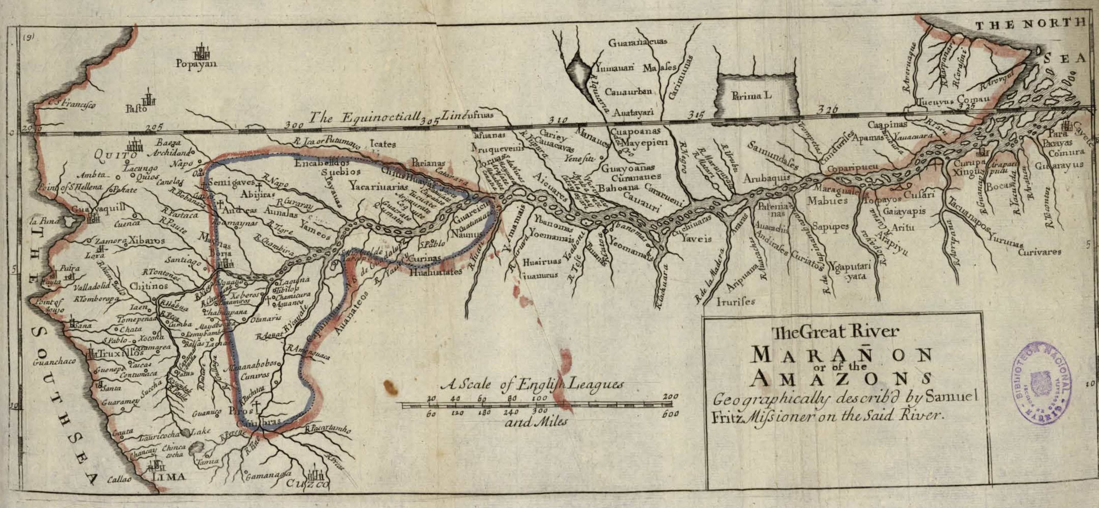
The Great River Marañon or of the Amazons

  • FRITZ, SAMUEL

Publicado: 1717

  • Descargar Imágen
  • Descargar Imágen
Mapa 1717

The Great River Marañon or of the Amazons

  • FRITZ, SAMUEL

Publicado: 1717

  • Descargar Imágen

Pueblos

  • GUARANACUAS
  • TUMAUARI
  • MAASES
  • CAUAURBAN
  • AUATAYARI
  • CARIMUNAS
  • TUCUYUS
  • COMAU
  • GUAYARUS
  • COMURA
  • PACAYAS
  • CURIVARES
  • YURUNAS
  • BOCAS
  • XINGU
  • TACUANAPOS
  • CUSARI
  • TOPAYOS
  • GAIAYAPIS
  • ARITU
  • ARAPIYU
  • MARAGUALES
  • MABUES
  • SAPUPES
  • YGAPUTARIYARA
  • PATENIANAS
  • AUACADUS
  • ANDIRASES
  • ARARAS
  • ARIPUANA
  • IRURISES
  • YAVEIS
  • CUCHIUARAS
  • YEOMAMAIS
  • PAUANAS
  • YBANOMAS
  • YOEMAMAIS
  • HUAIRUAS
  • IUANURUS
  • YEMAMAIS
  • HUAHUATATES
  • AUANATEOS
  • CAAPINAS
  • APAMAS
  • COPARIPUCU
  • CUNDURISES
  • SAMUNDASES
  • ARUBAQUIS
  • CUAPOANAS
  • MAYEPIEN
  • GUAYOANAS
  • CURANATIES
  • BAHOANA
  • CARARUENI
  • CAUAURI
  • MANAUES
  • CARIEY
  • CAUACAVAS
  • AICUARES
  • MORUAS
  • CASUANAS
  • PARIANAS
  • ICATES
  • GUAREICUS
  • NAUNUS
  • CURINAS
  • YACARIUARIAS
  • CHIUS
  • HUAYAS
  • SUCBIOS
  • ENCABELLDOS
  • PAYAUAS
  • SEMIGAVES
  • ABIJIRAS
  • ANDEAS
  • AUNALAS
  • YAMEOS
  • MAYNAS
  • CAPANATUAS
  • CAMBRAS
  • PIROS
  • CHITINOS

Citas

Fritz, Samuel. "The Great River Marañon or of the Amazons." Map. In America, by Herman Moll, 389. Vol. 5 of Atlas Geographus or, a compleat System of Geography, ancient and modern. London: John Nutt, 1717. Accessed July 14, 2023. http://bdh.bne.es/bnesearch/detalle/bdh0000163462.
  • Descargar Imágen

Artículos Relacionados

Reducción del territorio Barí 1950 -1970

Reducción del territorio Barí 1950 -1970

Mapa 1950 - 1970
The Southern Maya Lowlands during the Sixteenth and Seventeenth Centuries

The Southern Maya Lowlands during the Sixteenth and Seventeenth Centuries

Mapa 1500 - 1700
Geographical Distribution of the Huave

Geographical Distribution of the Huave

Mapa 1969
Mapa de resguardos indígenas

Mapa de resguardos indígenas

Mapa 2012
Partie de la Guiane française

Partie de la Guiane française

Mapa 1700 - 1799
Carte de l'embouchure d'Ouyapoc

Carte de l'embouchure d'Ouyapoc

Mapa 1700 - 1799
The Boundaries of Cuauhtinchan and Totomihuacan, Historia Tolteca-Chichimeca, pp. 1-2

The Boundaries of Cuauhtinchan and Totomihuacan, Historia Tolteca-Chichimeca, pp. 1-2

Mapa 1560
Plano General de las Nuevas Fronteras sobre La Pampa.

Plano General de las Nuevas Fronteras sobre La Pampa.

Mapa 1877

Despojos en las Américas

Un Proyecto de

University of Pennsylvania

Copyright 2024

Con el apoyo de

Mellon Foundation

Diseño y Desarrollo del Sitio

Element 84

Créditos Artísticos

Fritz, Samuel. “The Great River Marañon or of the Amazons.” Map. In America, by Herman Moll, 389. Vol. 5 of Atlas Geographus or, a compleat System of Geography, ancient and modern. London: John Nutt, 1717. Accessed July 14, 2023. http://bdh.bne.es/bnesearch/detalle/bdh0000163462.
Páginas del Sitio

  • Inicio
  • Explorar
  • Autores
  • Sobre
  • Arte
  • Cuerpos
  • Planes de Estudio
  • Herencia Cultural
  • Mapas
  • Territorios