Dispossesions in the Americas

Dispossesions in the Americas

  • Inicio
  • Explorar
  • Autores
  • Sobre
  • Arte
  • Cuerpos
  • Planes de Estudio
  • Herencia Cultural
  • Mapas
  • Territorios
Volver a Explorar

Leyendo en Inglés

Mapa 1717

A Map of BRASIL and Part of LA PLATA

  • MOLL, HERMAN

Publicado: 1717

  • Descargar Imágen
  • Descargar Imágen
Mapa 1717

A Map of BRASIL and Part of LA PLATA

  • MOLL, HERMAN

Publicado: 1717

  • Descargar Imágen

Pueblos

  • MAIAYUS
  • GUAYAZIS
  • TAPAYOSOS
  • GUARANAGUACAS
  • TAPUYER

Citas

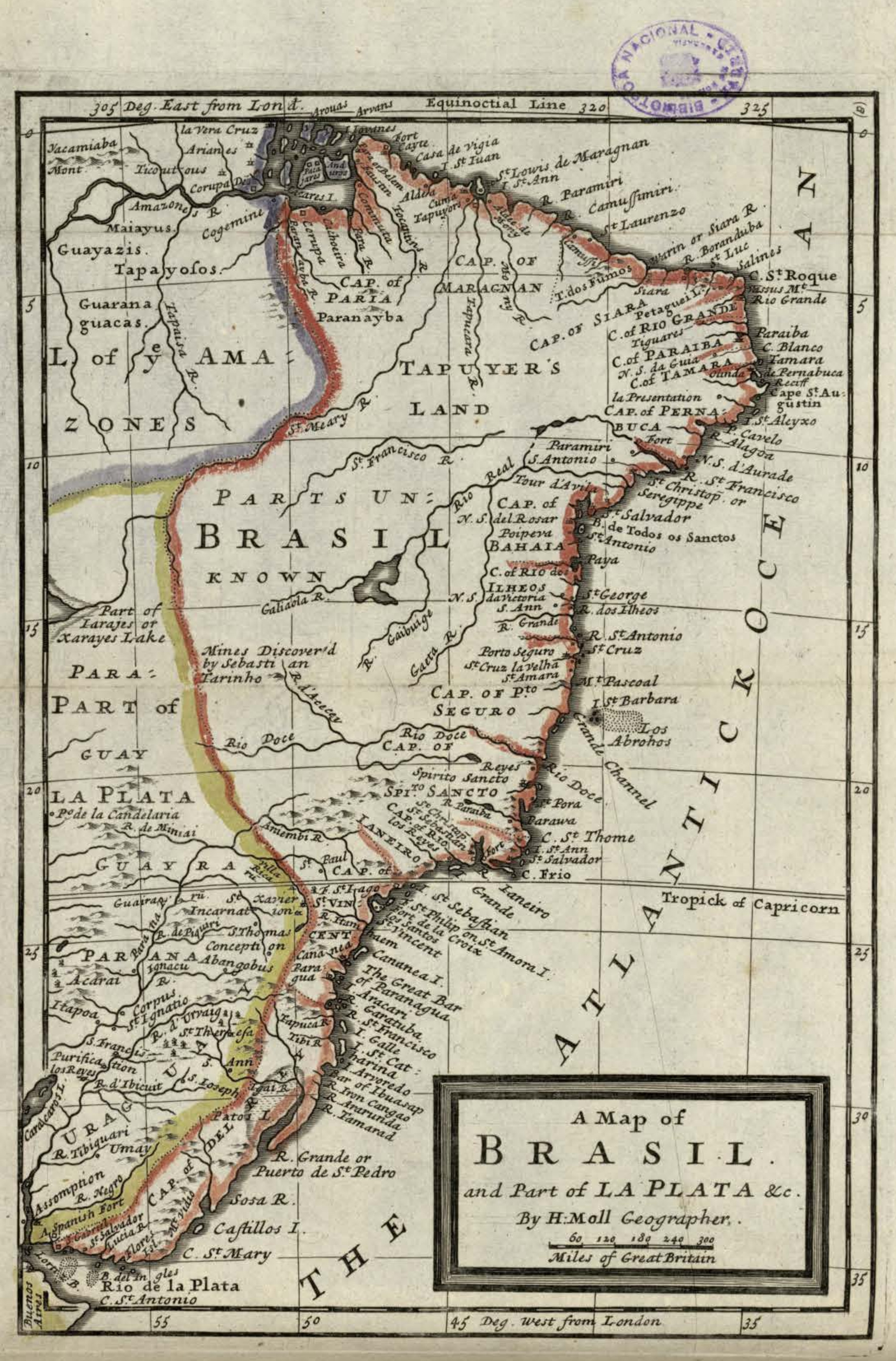
Moll, Herman. "A Map of Brasil and Part of La Plata." Map. In America, 254. Vol. 5 of Atlas Geographus or, a compleat System of Geography, ancient and modern. London: John Nutt, 1717. Accessed July 14, 2023. http://bdh.bne.es/bnesearch/detalle/bdh0000163462.

  • Descargar Imágen

Artículos Relacionados

AYMARA POLITIES AROUND THE TITICACA LAKE IN THE 15TH AND 16TH CENTURIES

AYMARA POLITIES AROUND THE TITICACA LAKE IN THE 15TH AND 16TH CENTURIES

Mapa 1548 - 1610
Mapa de la Distribucion de los Idiomas qu se hablan en Guatemala

Mapa de la Distribucion de los Idiomas qu se hablan en Guatemala

Mapa 1923
Totocanapan: Approximate Extension in Ancient and Recent Times

Totocanapan: Approximate Extension in Ancient and Recent Times

Mapa 1940
Map 2.3 The multilingual context of French Guiana (from Renault-Lescure and Goury 2009: 10)

Map 2.3 The multilingual context of French Guiana (from Renault-Lescure and Goury 2009: 10)

Mapa 2012
Mapa de la zona comprendida entre los rios Paraguay y Parana, con el noreste de Argentina y sur de Brasil

Mapa de la zona comprendida entre los rios Paraguay y Parana, con el noreste de Argentina y sur de Brasil

Mapa 1786 - 1791
Paskaerte vande cust van Westindien van R. Desaguadera tot C. de Honduras / beschreven door Arent Roggeveen

Paskaerte vande cust van Westindien van R. Desaguadera tot C. de Honduras / beschreven door Arent Roggeveen

Mapa 1675
TITLED INDIGENOUS TERRITORIES (TIOCs) IN THE BOLIVIAN HIGH PLATEAU by 2011

TITLED INDIGENOUS TERRITORIES (TIOCs) IN THE BOLIVIAN HIGH PLATEAU by 2011

Mapa 2011
THE TAWANTINSUYU IN THE 1530s – TERRITORY OF THE INCA STATE

THE TAWANTINSUYU IN THE 1530s – TERRITORY OF THE INCA STATE

Mapa 1530

Despojos en las Américas

Un Proyecto de

University of Pennsylvania

Copyright 2024

Con el apoyo de

Mellon Foundation

Diseño y Desarrollo del Sitio

Element 84

Créditos Artísticos

Moll, Herman. “A Map of Brasil and Part of La Plata.” Map. In America, 254. Vol. 5 of Atlas Geographus or, a compleat System of Geography, ancient and modern. London: John Nutt, 1717. Accessed July 14, 2023. http://bdh.bne.es/bnesearch/detalle/bdh0000163462.

Páginas del Sitio

  • Inicio
  • Explorar
  • Autores
  • Sobre
  • Arte
  • Cuerpos
  • Planes de Estudio
  • Herencia Cultural
  • Mapas
  • Territorios