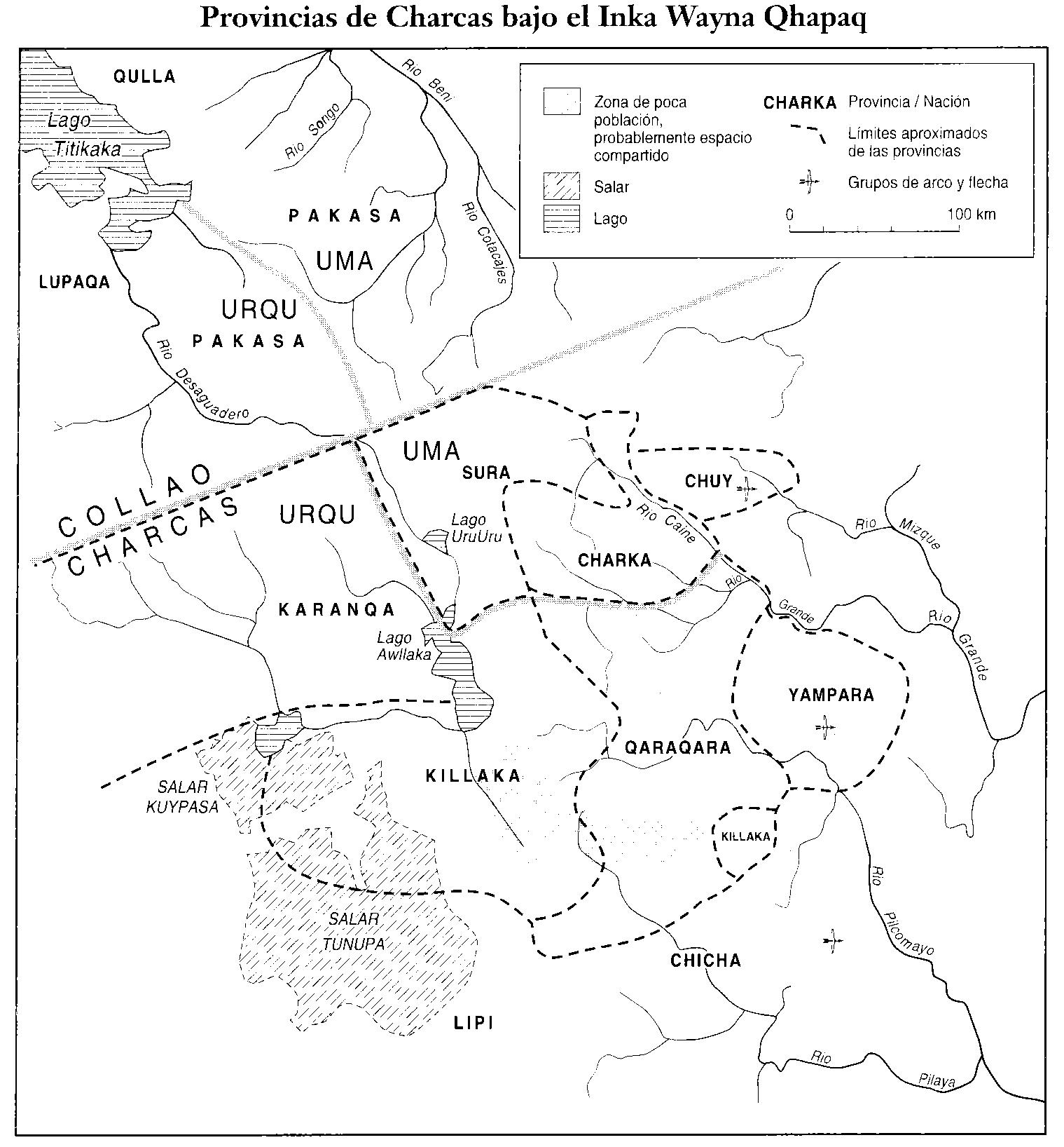
Dispossesions in the Americas

Dispossesions in the Americas

  • Inicio
  • Explorar
  • Autores
  • Sobre
  • Arte
  • Cuerpos
  • Planes de Estudio
  • Herencia Cultural
  • Mapas
  • Territorios
Volver a Explorar

Leyendo en Inglés

Mapa 1530 - 1540

PROVINCIAS DEL QULLASUYU BAJO DOMINIO INCA PRINCIPIOS DEL SIGLO XVI

  • Platt, T., Bouysse-Cassagne, T., & Harris, O.

Publicado: 2006

  • Descargar Imágen
  • Descargar Imágen
Mapa 1530 - 1540

PROVINCIAS DEL QULLASUYU BAJO DOMINIO INCA PRINCIPIOS DEL SIGLO XVI

  • Platt, T., Bouysse-Cassagne, T., & Harris, O.

Publicado: 2006

  • Descargar Imágen

Pueblos

  • LUPACAS
  • COLLA
  • PACAJES
  • SORAS
  • CARANGAS
  • QUILLACAS
  • CHARCAS
  • CHUY
  • QHARAQHARA
  • CHICHAS
  • YAMPARAEZ
  • LIPEZ

Citas

Platt, T., Bouysse-Cassagne, T., & Harris, O. (2006). Qaraqara-Charka: Mallku, Inka y rey en la Provincia de Charcas (siglos XV – XVII): Historia antropológica de una confederación aymara. Edición documental y ensayos interpretativos. Con el aliento de Thierry Saignes. Instituto Francés de Estudios Andinos, Plural Editores, Fundación Cultural del Banco Central de Bolivia, University of St. Andrews.

  • Descargar Imágen

Artículos Relacionados

PUEBLOS DE INDIOS DE LAS INTENDENCIAS Y GOBIERNOS MILITARES DE LA NUEVA ESPAÑA EN 1800 (4,468 PUEBLOS DE INDIOS)

PUEBLOS DE INDIOS DE LAS INTENDENCIAS Y GOBIERNOS MILITARES DE LA NUEVA ESPAÑA EN 1800 (4,468 PUEBLOS DE INDIOS)

Mapa 1800
LAS TRES OLAS DE COLONIZACION DE LA SNSM

LAS TRES OLAS DE COLONIZACION DE LA SNSM

Mapa 1900 - 1999
Present Distribution of the Otomi Family

Present Distribution of the Otomi Family

Mapa 1969
MAPA DE LA NUEVA PROVINCIA POBLADA DE BARBAROS, SITUADA EN LA COSTA DEL SENO MEXICANO, DESDE EL PUERTO DE TAMPICO HASTA LA PROVINCIA DE TEXAS

MAPA DE LA NUEVA PROVINCIA POBLADA DE BARBAROS, SITUADA EN LA COSTA DEL SENO MEXICANO, DESDE EL PUERTO DE TAMPICO HASTA LA PROVINCIA DE TEXAS

Mapa 1744
ACTUAL TERRITORIO NUKAK

ACTUAL TERRITORIO NUKAK

Mapa 1978
Guaraní Ñandéva

Guaraní Ñandéva

Mapa 2001
Modern Distribution and Location of Tzetzal and Tzotzil Communities

Modern Distribution and Location of Tzetzal and Tzotzil Communities

Mapa 1959
Paraguay Verdeelt in zyn voornaamste deelen Volgens de
     laatste reisbeschryvinge door N. Sanson d.'Abbeville, Geographe ordre. du
     Ro

Paraguay Verdeelt in zyn voornaamste deelen Volgens de laatste reisbeschryvinge door N. Sanson d.'Abbeville, Geographe ordre. du Ro

Mapa 1600 - 1667

Despojos en las Américas

Un Proyecto de

University of Pennsylvania

Copyright 2024

Con el apoyo de

Mellon Foundation

Diseño y Desarrollo del Sitio

Element 84

Créditos Artísticos

Platt, T., Bouysse-Cassagne, T., & Harris, O. (2006). Qaraqara-Charka: Mallku, Inka y rey en la Provincia de Charcas (siglos XV – XVII): Historia antropológica de una confederación aymara. Edición documental y ensayos interpretativos. Con el aliento de Thierry Saignes. Instituto Francés de Estudios Andinos, Plural Editores, Fundación Cultural del Banco Central de Bolivia, University of St. Andrews.

Páginas del Sitio

  • Inicio
  • Explorar
  • Autores
  • Sobre
  • Arte
  • Cuerpos
  • Planes de Estudio
  • Herencia Cultural
  • Mapas
  • Territorios