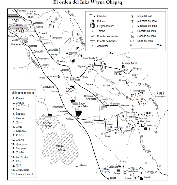
Dispossesions in the Americas

Dispossesions in the Americas

  • Inicio
  • Explorar
  • Autores
  • Sobre
  • Arte
  • Cuerpos
  • Planes de Estudio
  • Herencia Cultural
  • Mapas
  • Territorios
Volver a Explorar

Leyendo en Inglés

Mapa 1500 - 1530

SPATIAL ORGANIZATION OF THE QULLASUYU UNDER INCA RULE

  • Platt, T., Bouysse-Cassagne, T., & Harris, O.

Publicado: 2006

  • Descargar Imágen
  • Descargar Imágen
Mapa 1500 - 1530

SPATIAL ORGANIZATION OF THE QULLASUYU UNDER INCA RULE

  • Platt, T., Bouysse-Cassagne, T., & Harris, O.

Publicado: 2006

  • Descargar Imágen

Pueblos

  • KANARI
  • CHILLKI
  • SURA
  • LUPAQA
  • PAKASA (PACAJE)
  • QUTA
  • KARANQA
  • KILLAKA
  • CHARKA
  • QARAQARA
  • YAMPARA
  • CHICHA
  • IKA YUNKA
  • INKA
  • QULLA
  • QULLA
  • CHURUMATA
  • KANA
  • KANCHI

Citas

Platt, T., Bouysse-Cassagne, T., & Harris, O. (2006). Qaraqara-Charka: Mallku, Inka y rey en la Provincia de Charcas (siglos XV – XVII): Historia antropológica de una confederación aymara. Edicion documental y ensayos interpretativos. Con el aliento de Thierry Saignes. Instituto Frances de Estudios Andinos, Plural Editores, Fundacion Cultural del Banco Central de Bolivia, University of St. Andrews.

  • Descargar Imágen

Artículos Relacionados

MAP 2. DISTRIBUTION OF ETHNIC GROUPS OF THE SIERRA ON THE EVE OF SPANISH CONQUEST

MAP 2. DISTRIBUTION OF ETHNIC GROUPS OF THE SIERRA ON THE EVE OF SPANISH CONQUEST

Mapa 1490
SPEZIALKARTE von SANTA CATHARINA, RIO GRANDE DO SUL UND URUGUAY

SPEZIALKARTE von SANTA CATHARINA, RIO GRANDE DO SUL UND URUGUAY

Mapa 1907
Guatemala: lenguas y etnias indígenas. 2000

Guatemala: lenguas y etnias indígenas. 2000

Mapa 2000
Part of the Southwest 1600-1750 Showing Locations of "Unknown Athapaskans"

Part of the Southwest 1600-1750 Showing Locations of "Unknown Athapaskans"

Mapa 1600 - 1750
The Misquito: Most important municipios, 2001

The Misquito: Most important municipios, 2001

Mapa 2001
A MAP of the CARACAS

A MAP of the CARACAS

Mapa 1818
TERRITORIO TEÄRIME SIRI’KOI AERIME SUITITI

TERRITORIO TEÄRIME SIRI’KOI AERIME SUITITI

Mapa 2012
The modern departments of Ahuachapán, La Libertad, Santa Ana, and Sonsonate (highlighted in red) now contain the highest concentration of Indigenous communities in El Salvador.

The modern departments of Ahuachapán, La Libertad, Santa Ana, and Sonsonate (highlighted in red) now contain the highest concentration of Indigenous communities in El Salvador.

Mapa 2010

Despojos en las Américas

Un Proyecto de

University of Pennsylvania

Copyright 2024

Con el apoyo de

Mellon Foundation

Diseño y Desarrollo del Sitio

Element 84

Créditos Artísticos

Platt, T., Bouysse-Cassagne, T., & Harris, O. (2006). Qaraqara-Charka: Mallku, Inka y rey en la Provincia de Charcas (siglos XV – XVII): Historia antropológica de una confederación aymara. Edicion documental y ensayos interpretativos. Con el aliento de Thierry Saignes. Instituto Frances de Estudios Andinos, Plural Editores, Fundacion Cultural del Banco Central de Bolivia, University of St. Andrews.

Páginas del Sitio

  • Inicio
  • Explorar
  • Autores
  • Sobre
  • Arte
  • Cuerpos
  • Planes de Estudio
  • Herencia Cultural
  • Mapas
  • Territorios