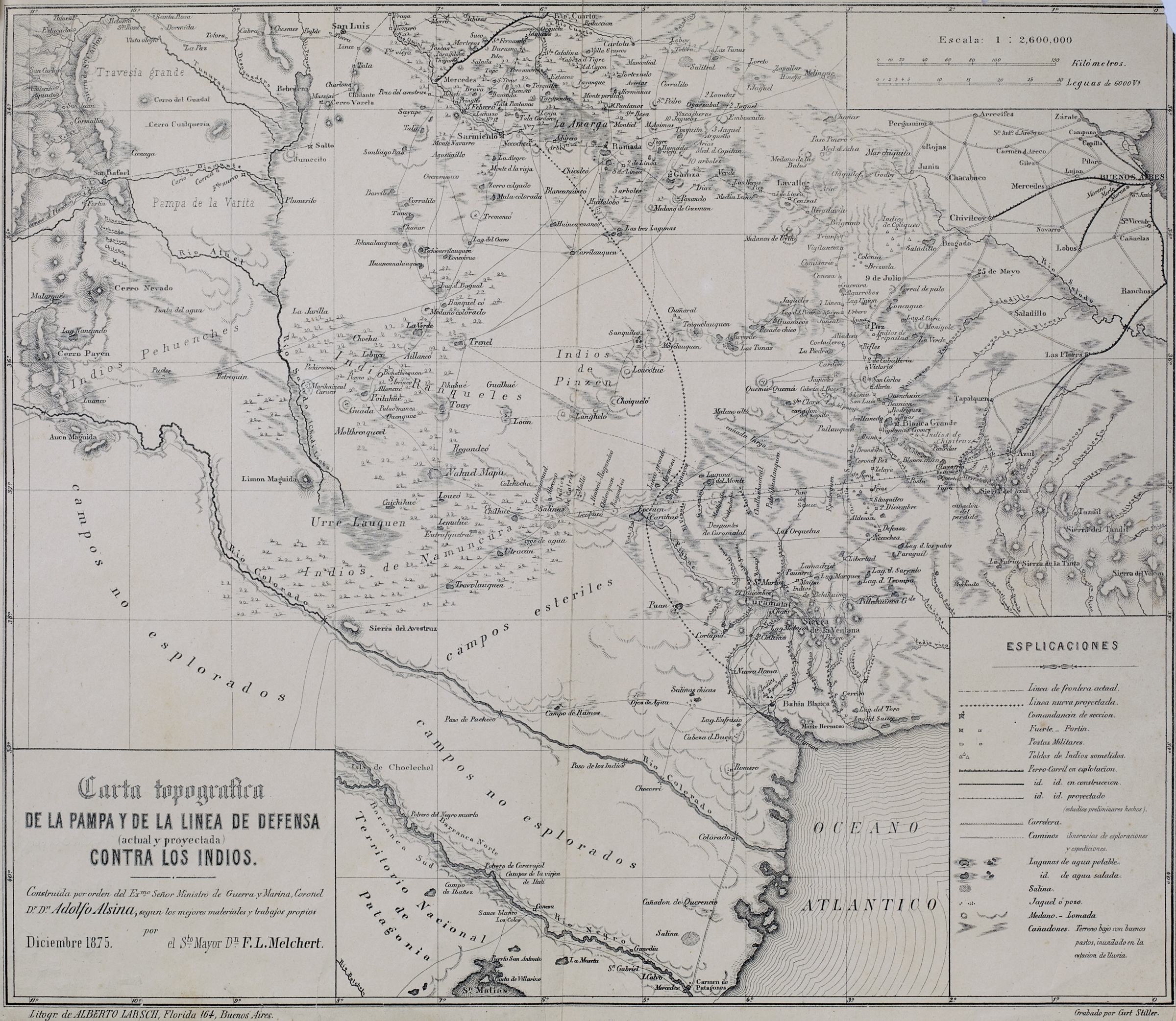
Dispossesions in the Americas

Dispossesions in the Americas

  • Inicio
  • Explorar
  • Autores
  • Sobre
  • Arte
  • Cuerpos
  • Planes de Estudio
  • Herencia Cultural
  • Mapas
  • Territorios
Volver a Explorar

Leyendo en Inglés

Mapa 1875

Carta topográfica de la Pampa y de la línea de defensa contra los indios.

  • Stiller Map

Publicado: 1875

  • Descargar Imágen
  • Descargar Imágen
Mapa 1875

Carta topográfica de la Pampa y de la línea de defensa contra los indios.

  • Stiller Map

Publicado: 1875

  • Descargar Imágen

Pueblos

  • RANQUEL
  • PEHUENCHES
  • INDIOS DE NAMUN CURA
  • INDIOS DE PINCEN

Citas

Stiller, Curt. Carta topográfica de la Pampa y de la línea de defensa contra los indios. Map. Buenos Aires: Litogr. de Alberto Larsch, 1875. https://catalogo.bn.gov.ar/exlibris1/apache_media/RN8H4KIJK539QUV2G9IT4QVX6G7UR2.jpg

  • Descargar Imágen

Artículos Relacionados

MAPA DEL ANTIGUO REINO DE GUATEMALA EN LA EPOCA DE SU DESCUBRIMIENTO Y CONQUISTA

MAPA DEL ANTIGUO REINO DE GUATEMALA EN LA EPOCA DE SU DESCUBRIMIENTO Y CONQUISTA

Mapa 1900 - 1999
Detail from the 1770 copy of Francisco Álvarez Barreiro’s 1728 map of northern New Spain illustrating Spanish mapping of Indian domains in southern Texas and along the Gulf Coast, especially through the repetition of labels: “tierra de los Pampopas,” “tierra de los Carrizos,” “tierra de los Cujanes,” etc.

Detail from the 1770 copy of Francisco Álvarez Barreiro’s 1728 map of northern New Spain illustrating Spanish mapping of Indian domains in southern Texas and along the Gulf Coast, especially through the repetition of labels: “tierra de los Pampopas,” “tierra de los Carrizos,” “tierra de los Cujanes,” etc.

Mapa 1728
LIENZO OF SANTO TOMÁS OCOTEPEQUE

LIENZO OF SANTO TOMÁS OCOTEPEQUE

Mapa 1580
CARTA ETNOGRÁFICA

CARTA ETNOGRÁFICA

Mapa 1885
Mixe Towns

Mixe Towns

Mapa 1969
Sketch of the country from reduction to Buenos Ayres, shewing the movements of B. Genl. Beresford, when he captured that place June 1806. Drawn from memorandums furnished by Capt: Donnelly

Sketch of the country from reduction to Buenos Ayres, shewing the movements of B. Genl. Beresford, when he captured that place June 1806. Drawn from memorandums furnished by Capt: Donnelly

Mapa 1806
Cartografía social. Confinamiento de las comunidades Wayuu en territorios del sur de La Guajira por el conflicto armado

Cartografía social. Confinamiento de las comunidades Wayuu en territorios del sur de La Guajira por el conflicto armado

Mapa
PUEBLO POPOLUCA DE LA SIERRA

PUEBLO POPOLUCA DE LA SIERRA

Mapa 2020

Despojos en las Américas

Un Proyecto de

University of Pennsylvania

Copyright 2024

Con el apoyo de

Mellon Foundation

Diseño y Desarrollo del Sitio

Element 84

Créditos Artísticos

Stiller, Curt. Carta topográfica de la Pampa y de la línea de defensa contra los indios. Map. Buenos Aires: Litogr. de Alberto Larsch, 1875. https://catalogo.bn.gov.ar/exlibris1/apache_media/RN8H4KIJK539QUV2G9IT4QVX6G7UR2.jpg

Páginas del Sitio

  • Inicio
  • Explorar
  • Autores
  • Sobre
  • Arte
  • Cuerpos
  • Planes de Estudio
  • Herencia Cultural
  • Mapas
  • Territorios