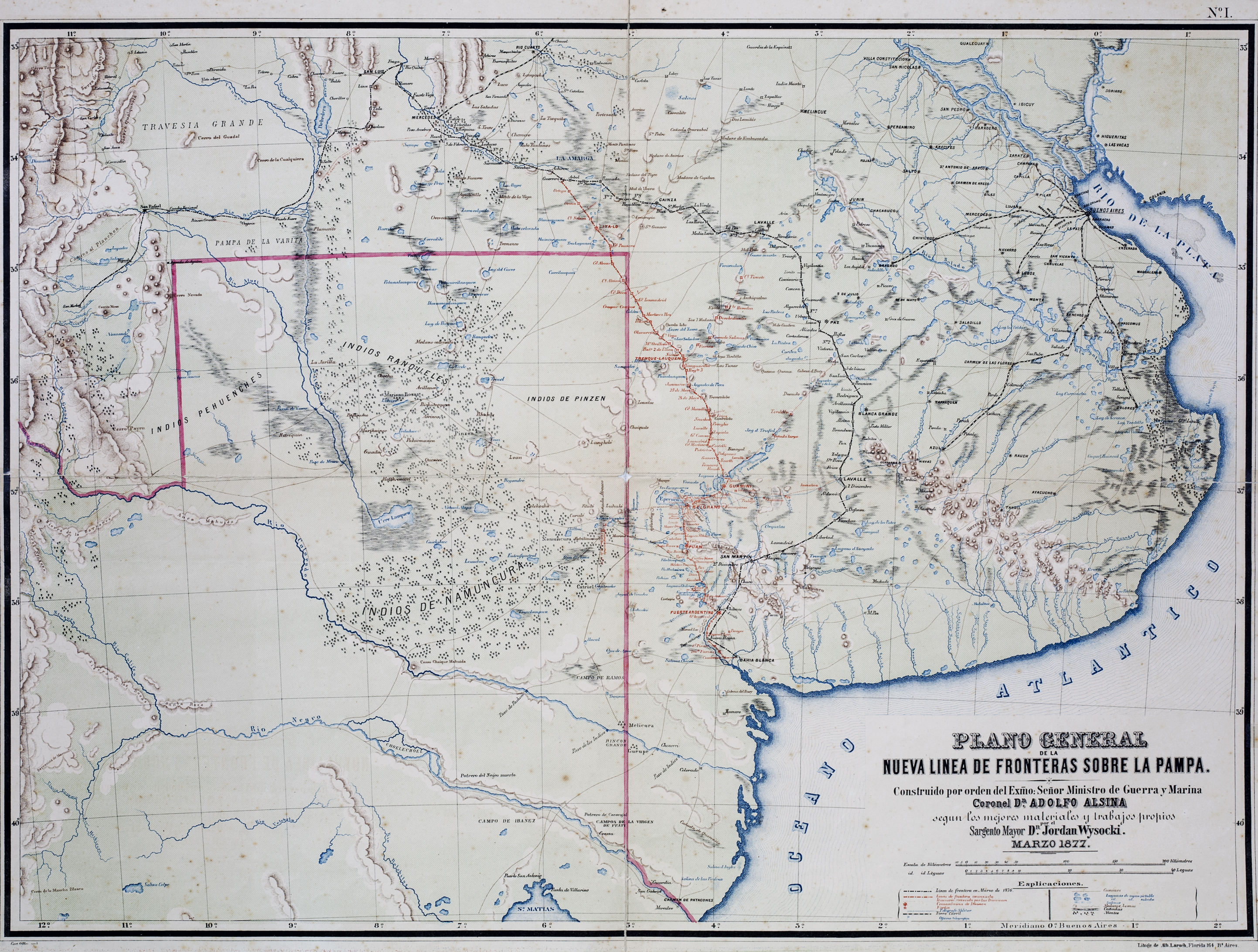
Dispossesions in the Americas

Dispossesions in the Americas

  • Inicio
  • Explorar
  • Autores
  • Sobre
  • Arte
  • Cuerpos
  • Planes de Estudio
  • Herencia Cultural
  • Mapas
  • Territorios
Volver a Explorar

Leyendo en Inglés

Mapa 1877

Plano General de las Nuevas Fronteras sobre La Pampa.

  • Wysocki, Jordan

Publicado: 1877

  • Descargar Imágen
  • Descargar Imágen
Mapa 1877

Plano General de las Nuevas Fronteras sobre La Pampa.

  • Wysocki, Jordan

Publicado: 1877

  • Descargar Imágen

Pueblos

  • RANQUEL
  • PEHUENCHES

Citas

Wysocki, Jordan. Plano General de las Nuevas Fronteras sobre La Pampa. Map. Buenos Aires: Litogr. de Alb. Larsch, 1877. Accessed November 1, 2021. https://catalogo.bn.gov.ar/exlibris1/apache_media/95CI153YLX3YEFBRR85P7EMVPJHTLQ.jpg

  • Descargar Imágen

Artículos Relacionados

Distribution of Nahuatl Population, Mexico

Distribution of Nahuatl Population, Mexico

Mapa 1969
ORDENAMIENTO POLÍTICO DEL ESPACIO BAJO EL DOMINIO COLONIAL A FINALES DEL SIGLO XVI

ORDENAMIENTO POLÍTICO DEL ESPACIO BAJO EL DOMINIO COLONIAL A FINALES DEL SIGLO XVI

Mapa 1580
República de Nicaragua: uso actual de la tierra;Territorios Indígenas/Afrodescendientes y Areas Protegidas

República de Nicaragua: uso actual de la tierra;Territorios Indígenas/Afrodescendientes y Areas Protegidas

Mapa 2012
SCHEMATIC MAP OF DISTRIBUTION OF MAYA-SPEAKING INDIANS (From Morley, 1956, pl.7)

SCHEMATIC MAP OF DISTRIBUTION OF MAYA-SPEAKING INDIANS (From Morley, 1956, pl.7)

Mapa
Cited Toldería Locations, 1750-1806

Cited Toldería Locations, 1750-1806

Mapa 1750 - 1806
BARÍ VILLAGES;1980s

BARÍ VILLAGES;1980s

Mapa 1980
Outlines of the physical and political division of South America: Delineated by A. Arrowsmith partly from scarce and original documents, published before the year 1806 but principally from manuscript maps & surveys made between the years 1771 and 1806, corrected from accurate astronomical observations to 1810.

Outlines of the physical and political division of South America: Delineated by A. Arrowsmith partly from scarce and original documents, published before the year 1806 but principally from manuscript maps & surveys made between the years 1771 and 1806, corrected from accurate astronomical observations to 1810.

Mapa 1800 - 1899
Descripción de las Indias Occidentales: Audiencia de Guatemala-Madrid

Descripción de las Indias Occidentales: Audiencia de Guatemala-Madrid

Mapa 1600 - 1699

Despojos en las Américas

Un Proyecto de

University of Pennsylvania

Copyright 2024

Con el apoyo de

Mellon Foundation

Diseño y Desarrollo del Sitio

Element 84

Créditos Artísticos

Wysocki, Jordan. Plano General de las Nuevas Fronteras sobre La Pampa. Map. Buenos Aires: Litogr. de Alb. Larsch, 1877. Accessed November 1, 2021. https://catalogo.bn.gov.ar/exlibris1/apache_media/95CI153YLX3YEFBRR85P7EMVPJHTLQ.jpg

Páginas del Sitio

  • Inicio
  • Explorar
  • Autores
  • Sobre
  • Arte
  • Cuerpos
  • Planes de Estudio
  • Herencia Cultural
  • Mapas
  • Territorios