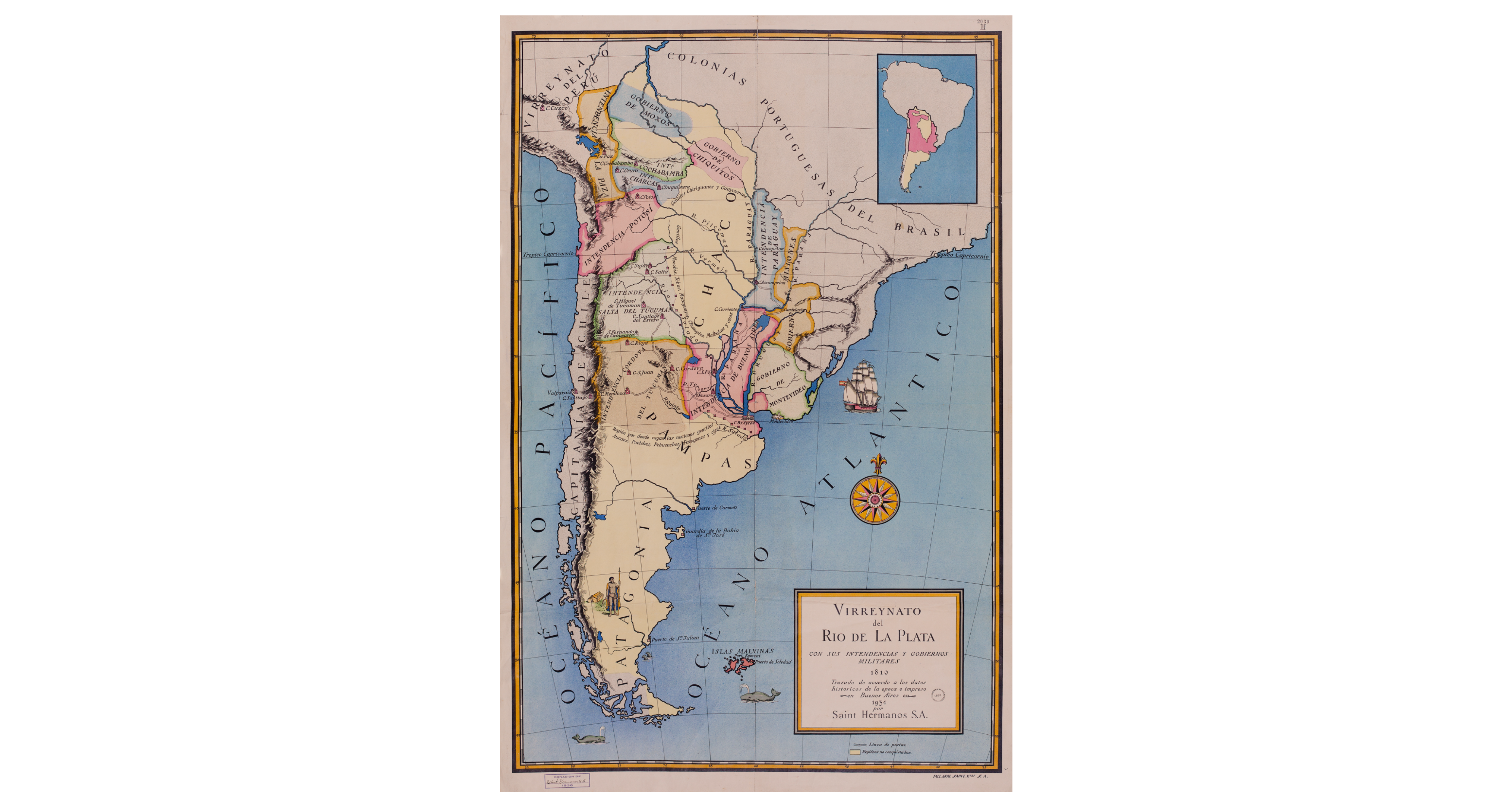
Dispossesions in the Americas

Dispossesions in the Americas

  • Inicio
  • Explorar
  • Autores
  • Sobre
  • Arte
  • Cuerpos
  • Planes de Estudio
  • Herencia Cultural
  • Mapas
  • Territorios
Volver a Explorar

Leyendo en Inglés

Mapa 1810

Virreynato del Río de La Plata con sus intendencias y gobiernos militares: 1810

  • Saint Hermanos

Publicado: 1934

  • Descargar Imágen
  • Descargar Imágen
Mapa 1810

Virreynato del Río de La Plata con sus intendencias y gobiernos militares: 1810

  • Saint Hermanos

Publicado: 1934

  • Descargar Imágen

Pueblos

  • GENTILES CHIRIGUANOS
  • GUAYCURUES
  • GENTILES
  • MOCOBIS
  • TOBAS
  • MATAGUAYOS
  • CHUNUPIES
  • MALBALAES
  • AUCAES
  • PUELCHES
  • PEHUENCHES
  • PATAGONES

Cita

SAINT HERMANOS. Virreynato del Río de La Plata con sus intendencias y gobiernos militares: 1810. Map. Buenos Aires, 1934. Accessed November 1, 2021. https://catalogo.bn.gov.ar/exlibris1/apache_media/Q5LRTHYHQ74NHTF41DPBAX9STPMVV9.jpg

  • Descargar Imágen

Leyendo en Portugués

Mapa 1810

Virreynato del Río de La Plata con sus intendencias y gobiernos militares: 1810

  • Saint Hermanos

Publicado: 1934

  • Descargar Imágen

Pueblos

  • GENTILES CHIRIGUANOS
  • GUAYCURUES
  • GENTILES
  • MOCOBIS
  • TOBAS
  • MATAGUAYOS
  • CHUNUPIES
  • MALBALAES
  • AUCAES
  • PUELCHES
  • PEHUENCHES
  • PATAGONES

Cita

SAINT HERMANOS. Virreynato del Río de La Plata con sus intendencias y gobiernos militares: 1810. Map. Buenos Aires, 1934. Accessed November 1, 2021. https://catalogo.bn.gov.ar/exlibris1/apache_media/Q5LRTHYHQ74NHTF41DPBAX9STPMVV9.jpg

  • Descargar Imágen

Artículos Relacionados

Peru, Amazones

Peru, Amazones

Mapa 1747
Theories of Migration (Charrúas).

Theories of Migration (Charrúas).

Mapa 1680 - 1805
Caminho do Kechuita, Aguapé, RS/Brasil

Caminho do Kechuita, Aguapé, RS/Brasil

Mapa 1999
"Senza titolo" ["Sin título"]

"Senza titolo" ["Sin título"]

Obra de Arte
CARTE DE LA COSTE DEPUIS LA RIVIERE DES AMAZONES JUSQUES A L'ISLE DE CAYENNE

CARTE DE LA COSTE DEPUIS LA RIVIERE DES AMAZONES JUSQUES A L'ISLE DE CAYENNE

Mapa 1701
Fig. 1 Map of the Guianas with schematic locations of the
indigenous groups relevant to our study, based on the linguistic
map of South America (http://www.muturzikin.com/cartesamerique/
7.htm). Carib-speaking groups are indicated in yellow, Arawak-speaking
groups in blue, Tupi-speaking Wayãpi in pink and the Warao-speaking
group in green

Fig. 1 Map of the Guianas with schematic locations of the indigenous groups relevant to our study, based on the linguistic map of South America (http://www.muturzikin.com/cartesamerique/ 7.htm). Carib-speaking groups are indicated in yellow, Arawak-speaking groups in blue, Tupi-speaking Wayãpi in pink and the Warao-speaking group in green

Mapa 2000 - 2024
[Panama]

[Panama]

Mapa 1730
Cayenne représentée exactement dans toutes ses rivières, criques et habitations et ses dehors

Cayenne représentée exactement dans toutes ses rivières, criques et habitations et ses dehors

Mapa 1717

Despojos en las Américas

Un Proyecto de

University of Pennsylvania

Copyright 2024

Con el apoyo de

Mellon Foundation

Diseño y Desarrollo del Sitio

Element 84

Créditos Artísticos

SAINT HERMANOS. Virreynato del Río de La Plata con sus intendencias y gobiernos militares: 1810. Map. Buenos Aires, 1934. Accessed November 1, 2021. https://catalogo.bn.gov.ar/exlibris1/apache_media/Q5LRTHYHQ74NHTF41DPBAX9STPMVV9.jpg

Páginas del Sitio

  • Inicio
  • Explorar
  • Autores
  • Sobre
  • Arte
  • Cuerpos
  • Planes de Estudio
  • Herencia Cultural
  • Mapas
  • Territorios