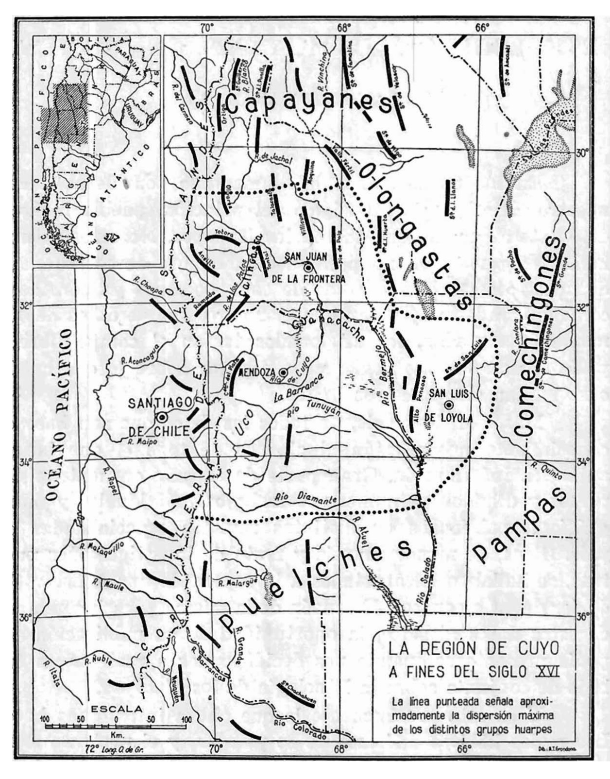
Dispossesions in the Americas

Dispossesions in the Americas

  • Inicio
  • Explorar
  • Autores
  • Sobre
  • Arte
  • Cuerpos
  • Planes de Estudio
  • Herencia Cultural
  • Mapas
  • Territorios
Volver a Explorar

Leyendo en Inglés

Mapa 1590

La región de Cuyo a fines del siglo XVI

  • CANALS FRAU, SALVADOR

Publicado: 1946

  • Descargar Imágen
  • Descargar Imágen
Mapa 1590

La región de Cuyo a fines del siglo XVI

  • CANALS FRAU, SALVADOR

Publicado: 1946

  • Descargar Imágen

Pueblos

  • PAMPAS
  • PUELCHE
  • COMECHINGON
  • OLONGASTA
  • CAPAYAN

Cita

"La región de cuyo a fines del siglo XVI." Map. In Anales del Instituto de Etnología Americana, by Salvador Canals Frau, 10. Vol. 7 of Etnologia de los Huarpes: una sintesis. 1946. Accessed June 5, 2021. https://bdigital.uncu.edu.ar/objetos_digitales/13712/rev-anales-1946-vol7-parte2.pdf

  • Descargar Imágen

Leyendo en Portugués

Mapa 1590

La región de Cuyo a fines del siglo XVI

  • CANALS FRAU, SALVADOR

Publicado: 1946

  • Descargar Imágen

Pueblos

  • PAMPAS
  • PUELCHE
  • COMECHINGON
  • OLONGASTA
  • CAPAYAN

Cita

"La región de cuyo a fines del siglo XVI." Map. In Anales del Instituto de Etnología Americana, by Salvador Canals Frau, 10. Vol. 7 of Etnologia de los Huarpes: una sintesis. 1946. Accessed June 5, 2021. https://bdigital.uncu.edu.ar/objetos_digitales/13712/rev-anales-1946-vol7-parte2.pdf

  • Descargar Imágen

Artículos Relacionados

Map of deforestation within protected areas in Guatemala and adjoining areas

Map of deforestation within protected areas in Guatemala and adjoining areas

Mapa 2000 - 2100
Map of "Jicaque" lands, by Governor Ramón Anguiano, 1798

Map of "Jicaque" lands, by Governor Ramón Anguiano, 1798

Mapa 1798
FAMILIAS LINGUISTICAS Y LENGUAS INDIGENAS - PRIMERA REGION: COSTA PACIFICA

FAMILIAS LINGUISTICAS Y LENGUAS INDIGENAS - PRIMERA REGION: COSTA PACIFICA

Mapa 1989
MAPA LINGÜÍSTICO DEL PAIS

MAPA LINGÜÍSTICO DEL PAIS

Mapa 2009 - 2010
"Territorio Indígena Matambú (Chorotega)"

"Territorio Indígena Matambú (Chorotega)"

Mapa 2010
MAPA COMUNITARIA DE INDIGENAS WUANANA

MAPA COMUNITARIA DE INDIGENAS WUANANA

Mapa 1996
Outlines of the physical and political division of South America: Delineated by A. Arrowsmith partly from scarce and original documents, published before the year 1806 but principally from manuscript maps & surveys made between the years 1771 and 1806, corrected from accurate astronomical observations to 1810.

Outlines of the physical and political division of South America: Delineated by A. Arrowsmith partly from scarce and original documents, published before the year 1806 but principally from manuscript maps & surveys made between the years 1771 and 1806, corrected from accurate astronomical observations to 1810.

Mapa 1800 - 1899
Comunidad "Territorio Indígena General E. Mosconi Tres Paraísos" - Pueblo Wichí

Comunidad "Territorio Indígena General E. Mosconi Tres Paraísos" - Pueblo Wichí

Mapa 2020

Despojos en las Américas

Un Proyecto de

University of Pennsylvania

Copyright 2024

Con el apoyo de

Mellon Foundation

Diseño y Desarrollo del Sitio

Element 84

Créditos Artísticos

“La región de cuyo a fines del siglo XVI.” Map. In Anales del Instituto de Etnología Americana, by Salvador Canals Frau, 10. Vol. 7 of Etnologia de los Huarpes: una sintesis. 1946. Accessed June 5, 2021. https://bdigital.uncu.edu.ar/objetos_digitales/13712/rev-anales-1946-vol7-parte2.pdf

Páginas del Sitio

  • Inicio
  • Explorar
  • Autores
  • Sobre
  • Arte
  • Cuerpos
  • Planes de Estudio
  • Herencia Cultural
  • Mapas
  • Territorios