Dispossesions in the Americas

Dispossesions in the Americas

  • Home
  • Explore
  • About
  • Authors
  • Art
  • Bodies
  • Curricula
  • Cultural Heritage
  • Maps
  • Territories
Back to Explore
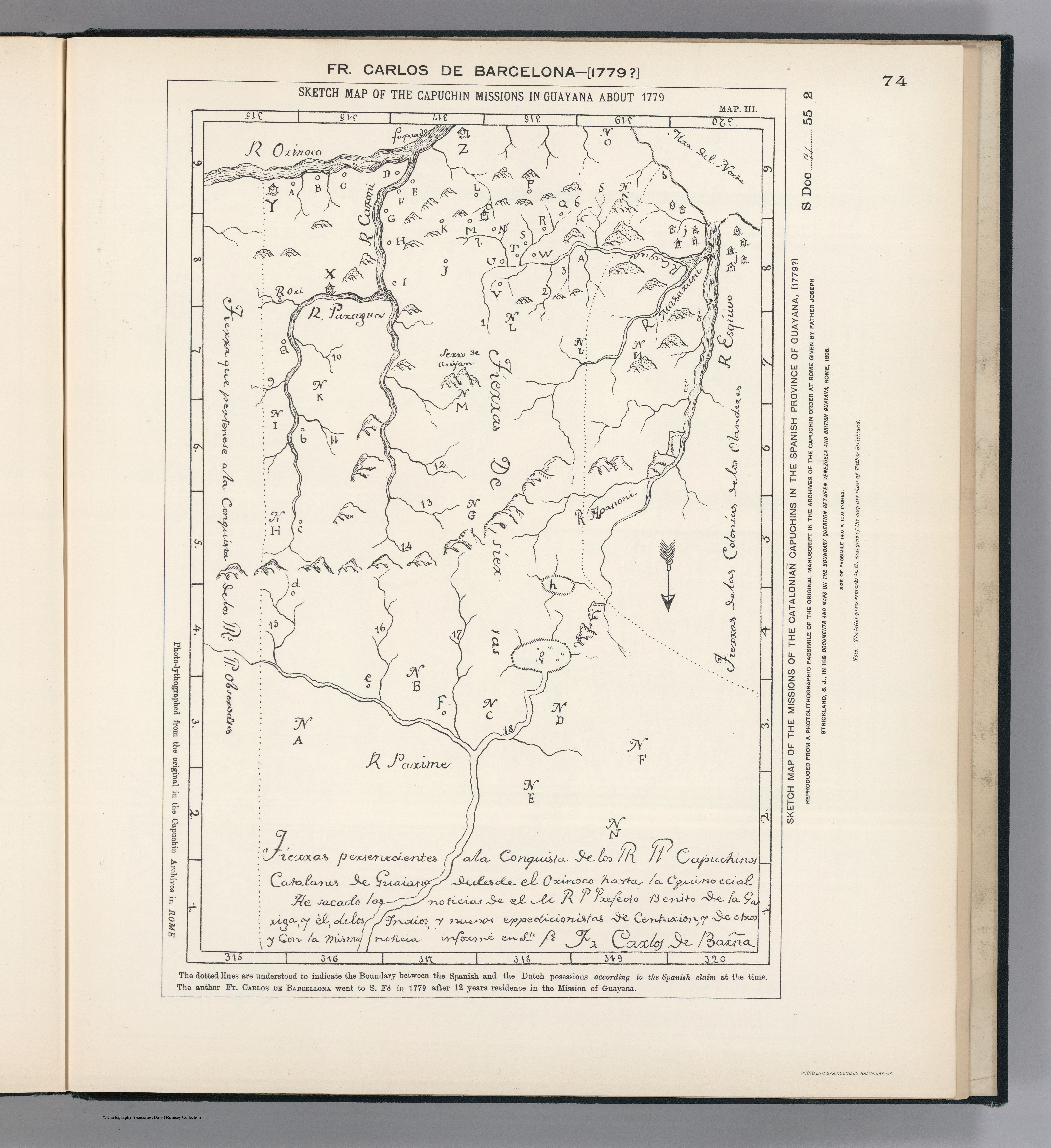
Map 1779

SKETCH MAP OF THE CAPUCHIN MISSIONS IN GUAYANA ABOUT 1779

  • CARLOS DE BARCELONA;F.

Published: 1898

  • Download Image

Peoples

  • PARIAGOTOS
  • DISSERRADOS
  • SALIVAS
  • GARAN
  • GARAUNOS
  • ARUACOS
  • CARIBES
  • GUAYCAS
  • PARIAPO

Citation

Carlos de Barcelona;F. Sketch Map of the Capuchin Missions in Guayana about 1779. Map. Reproduced from a Photolithographic Facsimile of the Manuscript Original in the Archives of the Capuchin Order at Rome given by Father Joseph Strickland, S.J., in his Documents and Maps on the Boundary Question between Venezuela and British Guayana, Rome, 1898. Photo. Lith. by A. Hoen & Co., Baltimore MD. Accessed March 4;2023. https://searchworks.stanford.edu/view/bw170wt2006.
  • Download Image

Reading in Spanish

Map 1779

SKETCH MAP OF THE CAPUCHIN MISSIONS IN GUAYANA ABOUT 1779

  • CARLOS DE BARCELONA;F.

Published: 1898

  • Download Image
  • Download Image

Related Content

"Territorio Indígena Conte Burica (Ngöbes)

"Territorio Indígena Conte Burica (Ngöbes)

Map 2010
BRASIL

BRASIL

Map 1800 - 1899
Location of Nahuat Area on Gulf Coast Plain

Location of Nahuat Area on Gulf Coast Plain

Map 1969
Mapa geográfico de América meridional.

Mapa geográfico de América meridional.

Map 1755
LIENZO DE ZACATEPEC

LIENZO DE ZACATEPEC

Map 1500 - 1599
LOCALIZACIÓN DE LOS PUEBLOS INDÍGENAS EN LA ARGENTINA

LOCALIZACIÓN DE LOS PUEBLOS INDÍGENAS EN LA ARGENTINA

Map 2004
SEÑORÍOS AYMARAS DE LOS CHARKA Y ENTIDADES POLÍTICAS VECINAS NO AYMARAS, A FINALES DEL SIGLO XV Y PRINCIPIOS DEL SIGLO XVI

SEÑORÍOS AYMARAS DE LOS CHARKA Y ENTIDADES POLÍTICAS VECINAS NO AYMARAS, A FINALES DEL SIGLO XV Y PRINCIPIOS DEL SIGLO XVI

Map 1500
PUEBLO OCAINA

PUEBLO OCAINA

Map 2021

Dispossessions in the Americas

A project by

University of Pennsylvania

Copyright 2024

With support from

Mellon Foundation

Site design & development

Element 84

Art Credits

Carlos de Barcelona;F. Sketch Map of the Capuchin Missions in Guayana about 1779. Map. Reproduced from a Photolithographic Facsimile of the Manuscript Original in the Archives of the Capuchin Order at Rome given by Father Joseph Strickland, S.J., in his Documents and Maps on the Boundary Question between Venezuela and British Guayana, Rome, 1898. Photo. Lith. by A. Hoen & Co., Baltimore MD. Accessed March 4;2023. https://searchworks.stanford.edu/view/bw170wt2006.
Site Pages

  • Home
  • Explore
  • About
  • Authors
  • Art
  • Bodies
  • Curricula
  • Cultural Heritage
  • Maps
  • Territories