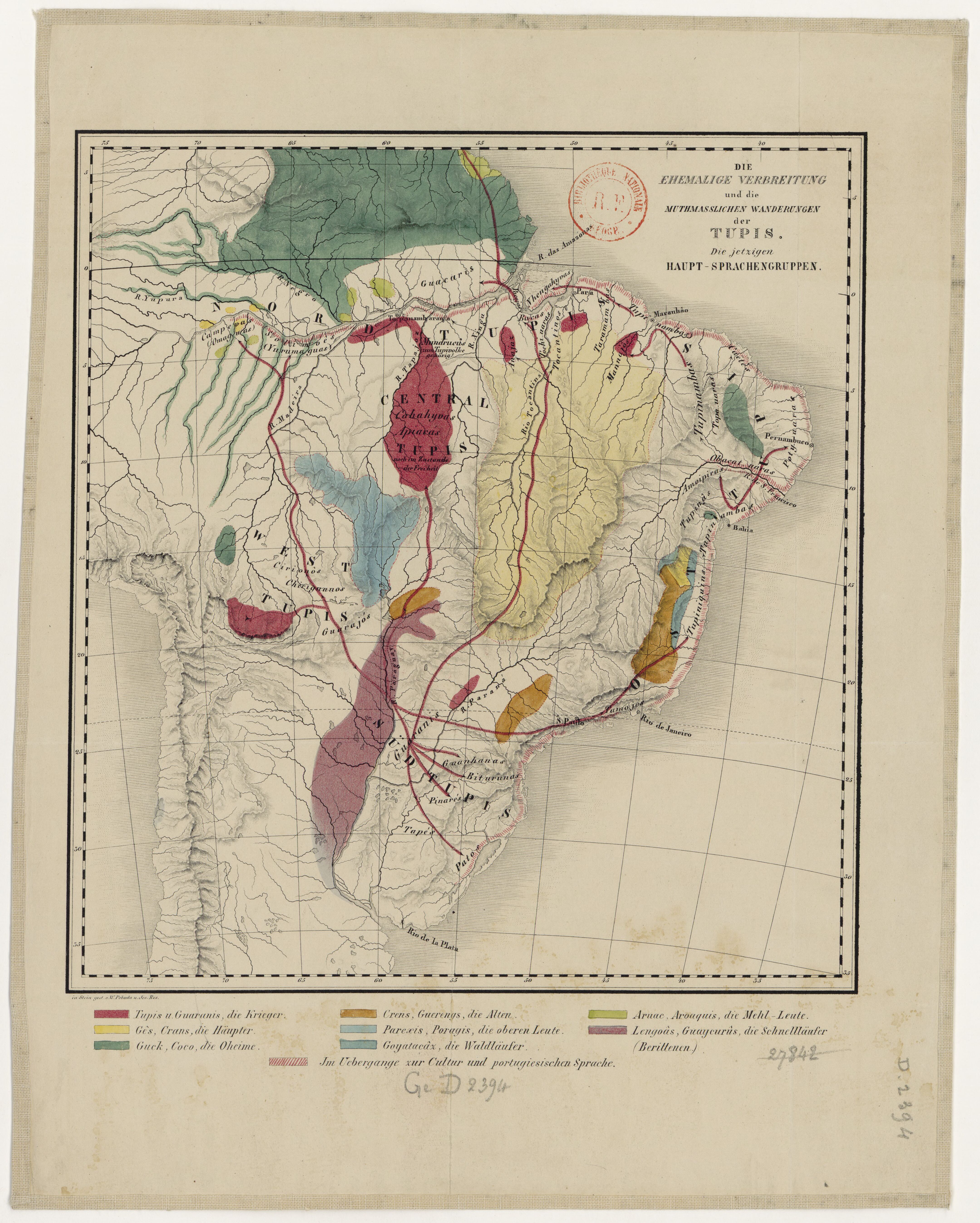
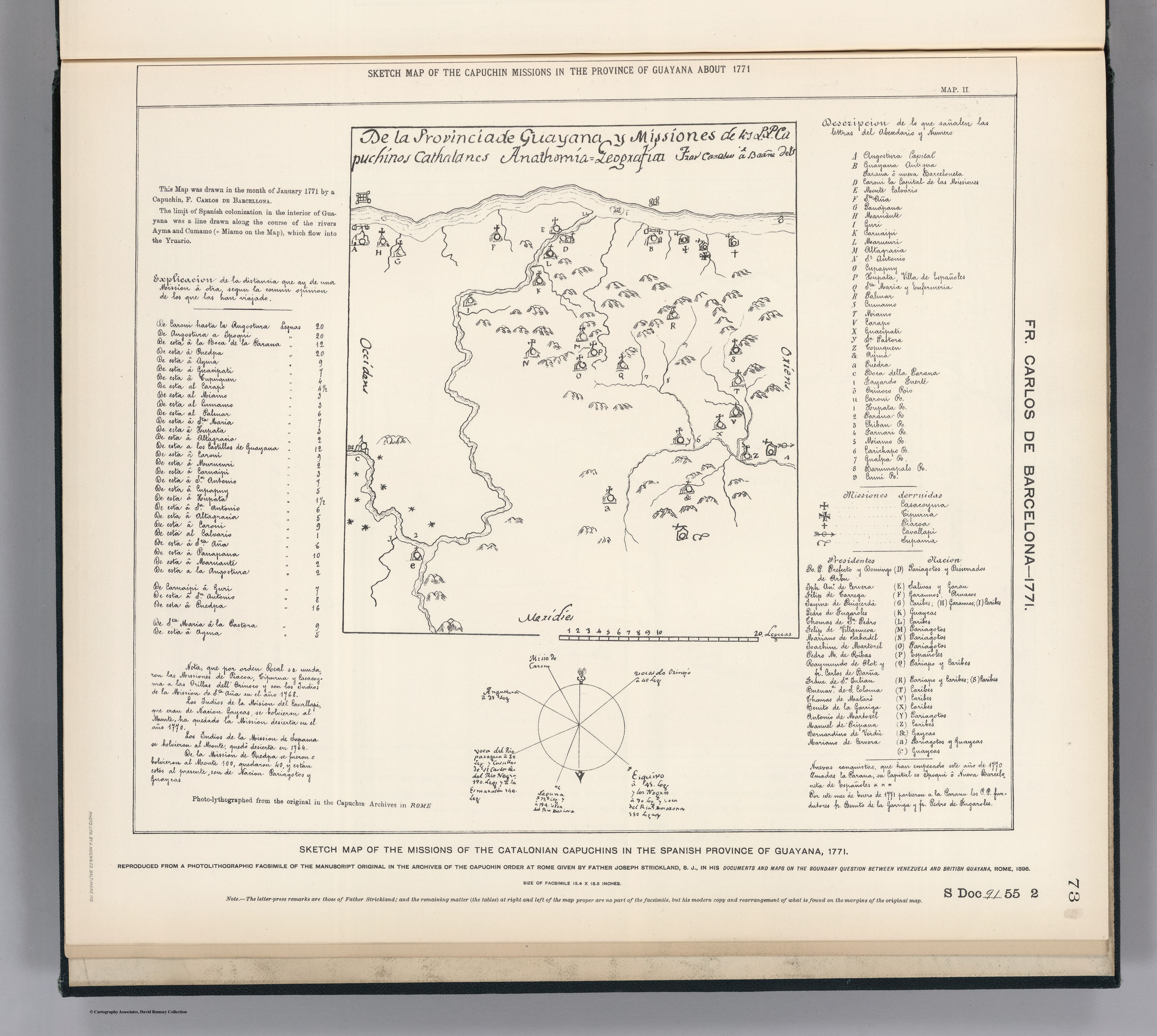
Dispossesions in the Americas

Dispossesions in the Americas

  • Home
  • Explore
  • About
  • Authors
  • Art
  • Bodies
  • Curricula
  • Cultural Heritage
  • Maps
  • Territories
Back to Explore
Map 1771

SKETCH MAP OF THE MISSIONS OF THE CATALONIAN CAPUCHINS IN THE SPANISH PROVINCE OF GUAYANA ABOUT 1771

  • CARLOS DE BARCELONA;F.

Published: 1898

  • Download Image

Peoples

  • PARIAGOTOS
  • DISSERRADOS
  • SALIVAS
  • GARAN
  • GARAUNOS
  • ARUACOS
  • CARIBES
  • GUAYCAS
  • PARIAPO

Citation

Carlos de Barcelona;F. Sketch Map of the Missions of the Catalonian Capuchins in the Spanish Province of Guayana about 1771. Map. Reproduced from a Photolithographic Facsimile of the Manuscript Original in the Archives of the Capuchin Order at Rome given by Father Joseph Strickland, S.J., in his Documents and Maps on the Boundary Question between Venezuela and British Guayana, Rome, 1898. Photo. Lith. by A. Hoen & Co., Baltimore MD. Accessed March 4;2023. https://searchworks.stanford.edu/view/bw170wt2006.

  • Download Image

Reading in Spanish

Map 1771

SKETCH MAP OF THE MISSIONS OF THE CATALONIAN CAPUCHINS IN THE SPANISH PROVINCE OF GUAYANA ABOUT 1771

  • CARLOS DE BARCELONA;F.

Published: 1898

  • Download Image
  • Download Image

Related Content

EL TERRITORIO AYOREO EN EL MAPA DE PARAGUAY HOY

EL TERRITORIO AYOREO EN EL MAPA DE PARAGUAY HOY

Map 2010
Mixe Towns

Mixe Towns

Map 1969
Mapa por despacho de Vice-ministerios

Mapa por despacho de Vice-ministerios

Map 2012
TAMÁRÃHO

TAMÁRÃHO

Map 2015
Map of Honduras and San Salvador, Central America, Showing the line of the proposed Honduras Interoceanic Railway

Map of Honduras and San Salvador, Central America, Showing the line of the proposed Honduras Interoceanic Railway

Map 1854
Cette Carte de Californie et du Nouveau Mexique

Cette Carte de Californie et du Nouveau Mexique

Map 1705
Missions of Guayrá and Tape until 1641

Missions of Guayrá and Tape until 1641

Map 1641
Plan de la Mission de Kourou et de ses Environs dans lequel on voit l'Etat dans lequel étoit le pays lors de l'arrivée de Monsieur de Préfontaine le 17 juillet 1763

Plan de la Mission de Kourou et de ses Environs dans lequel on voit l'Etat dans lequel étoit le pays lors de l'arrivée de Monsieur de Préfontaine le 17 juillet 1763

Map 1763

Dispossessions in the Americas

A project by

University of Pennsylvania

Copyright 2024

With support from

Mellon Foundation

Site design & development

Element 84

Art Credits

Carlos de Barcelona;F. Sketch Map of the Missions of the Catalonian Capuchins in the Spanish Province of Guayana about 1771. Map. Reproduced from a Photolithographic Facsimile of the Manuscript Original in the Archives of the Capuchin Order at Rome given by Father Joseph Strickland, S.J., in his Documents and Maps on the Boundary Question between Venezuela and British Guayana, Rome, 1898. Photo. Lith. by A. Hoen & Co., Baltimore MD. Accessed March 4;2023. https://searchworks.stanford.edu/view/bw170wt2006.

Site Pages

  • Home
  • Explore
  • About
  • Authors
  • Art
  • Bodies
  • Curricula
  • Cultural Heritage
  • Maps
  • Territories