Dispossesions in the Americas

Dispossesions in the Americas

  • Home
  • Explore
  • About
  • Authors
  • Art
  • Bodies
  • Curricula
  • Cultural Heritage
  • Maps
  • Territories
Back to Explore
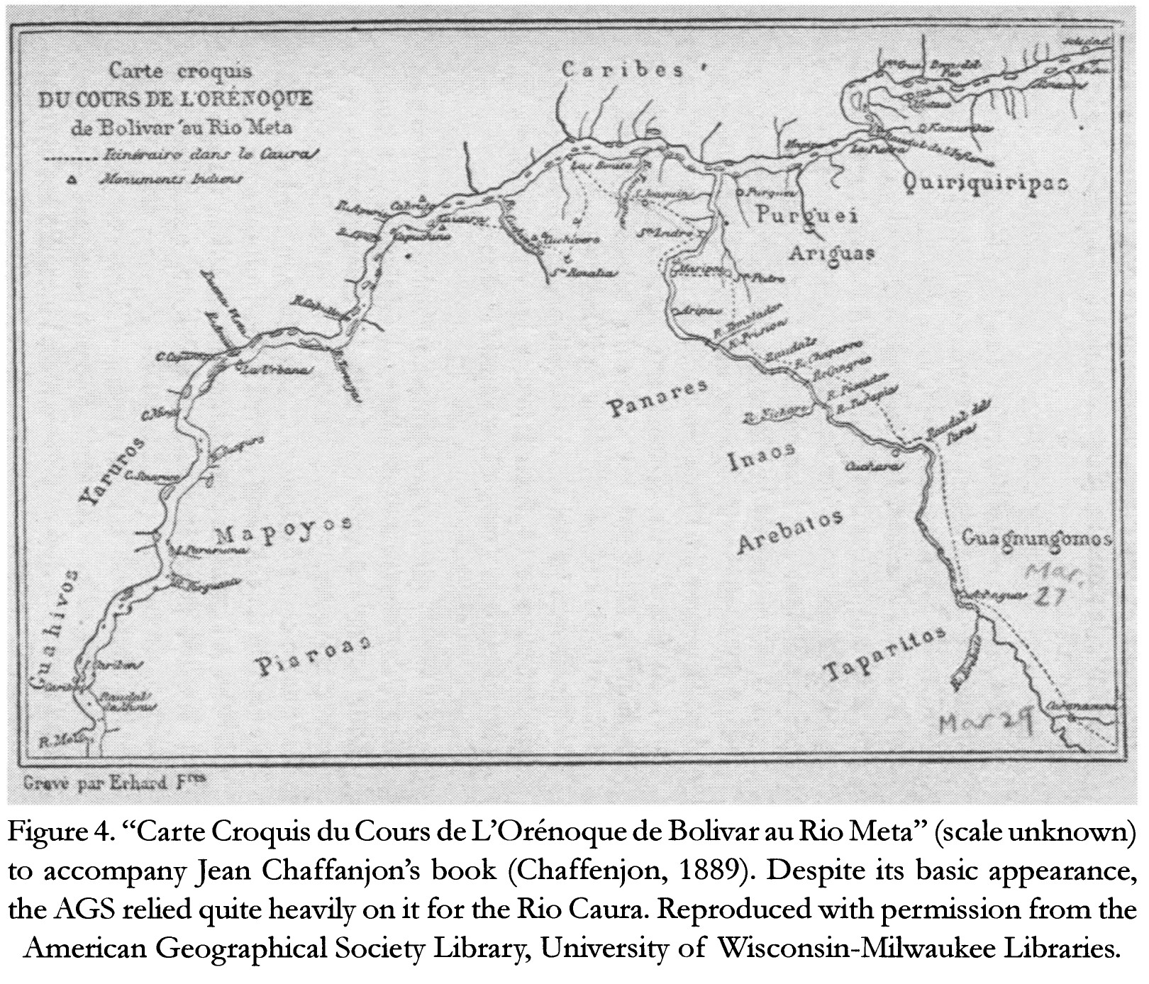
Map 1884

Carte Croquis DU COURS DE L'ORÉNOQUE de Bolivar àu Rio Meta

  • CHAFFANJON;JEAN

Published: 2015

  • Download Image

Peoples

  • CARIBE
  • QUIRIQUIRIPAS
  • PURGUEI
  • ARIGUAS
  • ENEPA
  • INAOS
  • AREBATOS
  • TAPARITAS
  • GUAGNUNGOMOS
  • YARURO
  • MAPOYO
  • PIAROA
  • JIVI

Citation

Chaffanjon;Jean. "Carte Croquis du Cours de L'Orénoque de Bolivar au Rio Meta." Map. In Revealing the 'Lost World': The American Geographical Society and the Mapping of Roraima during the 1930s;by Alastair Pearson and Michael Heffernan;188. Vol. 14. Journal of Latin American Geography;2015. Accessed March 4;2023. https://www.jstor.org/stable/43964634?seq=19.
  • Download Image

Reading in Spanish

Map 1884

Carte Croquis DU COURS DE L'ORÉNOQUE de Bolivar àu Rio Meta

  • CHAFFANJON;JEAN

Published: 2015

  • Download Image
  • Download Image

Related Content

Carte particulière de la colonie de Cayenne. Levée et présentée à Monseigneur le Comte de Pontchartrain, Ministre et secrétaire d'Etat ;Par son très humble serviteur et très obéissant serviteur De Créanton officier de la marine

Carte particulière de la colonie de Cayenne. Levée et présentée à Monseigneur le Comte de Pontchartrain, Ministre et secrétaire d'Etat ;Par son très humble serviteur et très obéissant serviteur De Créanton officier de la marine

Map 1701
Descripción de las provincias del Chaco y confinantes según las relaciones modernas y noticias adquiridas por diversas entradas de los misioneros de la Compañía de Jesús que se han hecho en este siglo de 1700

Descripción de las provincias del Chaco y confinantes según las relaciones modernas y noticias adquiridas por diversas entradas de los misioneros de la Compañía de Jesús que se han hecho en este siglo de 1700

Map 1700 - 1799
REGIÓN CHIMALAPAS

REGIÓN CHIMALAPAS

Map 2000
PUEBLO MURUI-MUINANI

PUEBLO MURUI-MUINANI

Map 2021
PUEBLO NAHUA DE NAYARIT

PUEBLO NAHUA DE NAYARIT

Map 2020
PUEBLO TLAHUICA

PUEBLO TLAHUICA

Map 2020
Cover-up of the Christopher Columbus statue behind the Bayfront Park Amphitheater in Miami, Florida

Cover-up of the Christopher Columbus statue behind the Bayfront Park Amphitheater in Miami, Florida

Artwork
PUEBLO Q'EQCHI'

PUEBLO Q'EQCHI'

Map 2020

Dispossessions in the Americas

A project by

University of Pennsylvania

Copyright 2024

With support from

Mellon Foundation

Site design & development

Element 84

Art Credits

Chaffanjon;Jean. “Carte Croquis du Cours de L’Orénoque de Bolivar au Rio Meta.” Map. In Revealing the ‘Lost World’: The American Geographical Society and the Mapping of Roraima during the 1930s;by Alastair Pearson and Michael Heffernan;188. Vol. 14. Journal of Latin American Geography;2015. Accessed March 4;2023. https://www.jstor.org/stable/43964634?seq=19.
Site Pages

  • Home
  • Explore
  • About
  • Authors
  • Art
  • Bodies
  • Curricula
  • Cultural Heritage
  • Maps
  • Territories