Dispossesions in the Americas

Dispossesions in the Americas

  • Home
  • Explore
  • About
  • Authors
  • Art
  • Bodies
  • Curricula
  • Cultural Heritage
  • Maps
  • Territories
Back to Explore
Map 1895

The Barima River as depicted on Dixon's compass traverse and the AGS million-scale map published in 1940 (bottom)

  • DIXON;GEORGE

Published: 2015

  • Download Image

Peoples

  • CARIBE
  • GUAICAS

Citation

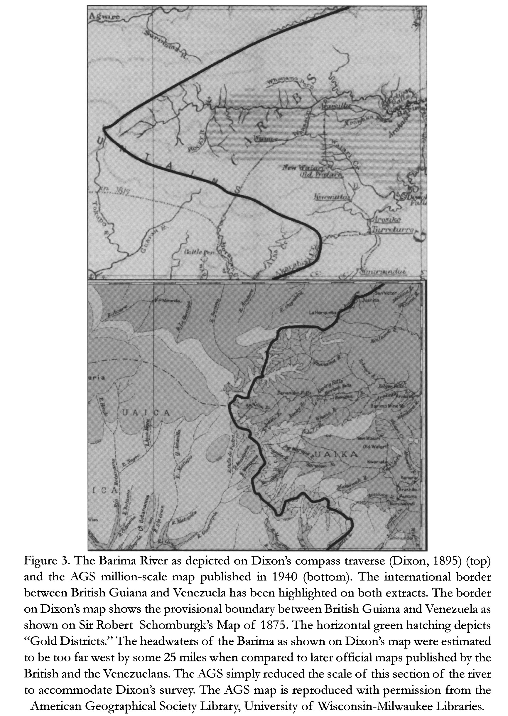
Dixon;George. "The Barima River as depicted on Dixon's compass traverse and the AGS million-scale map published in 1940 (bottom)." Map. In Revealing the 'Lost World': The American Geographical Society and the Mapping of Roraima during the 1930s;by Alastair Pearson and Michael Heffernan;186. Vol. 14. Journal of Latin American Geography;2015. Accessed March 4;2023. https://www.jstor.org/stable/43964634?seq=19.

  • Download Image

Reading in Spanish

Map 1895

The Barima River as depicted on Dixon's compass traverse and the AGS million-scale map published in 1940 (bottom)

  • DIXON;GEORGE

Published: 2015

  • Download Image
  • Download Image

Related Content

Plano del Puerto de Quilqua

Plano del Puerto de Quilqua

Map 1700 - 1799
Honduras: Distribution of ethnic groups, ca. 1980 (Davidson and Counce 1989)

Honduras: Distribution of ethnic groups, ca. 1980 (Davidson and Counce 1989)

Map 1980
Mapa topográfico que señala las Misiones de don José Miguel Vásquez en el Casanare.

Mapa topográfico que señala las Misiones de don José Miguel Vásquez en el Casanare.

Map 1769
A Gente Rio /We River

A Gente Rio /We River

Artwork
PART OF A CHART OF THE NORTHERN COAST OF SOUTH AMERICA BY THOMAS JEFFERYS

PART OF A CHART OF THE NORTHERN COAST OF SOUTH AMERICA BY THOMAS JEFFERYS

Map 1792
Guatemala: From Official and Other Sources

Guatemala: From Official and Other Sources

Map 1900 - 1902
An exact draught of the river of Bellese as high as the Barcadares. A new draught of the bay of Honduras by Capt. Nathaniel Uring

An exact draught of the river of Bellese as high as the Barcadares. A new draught of the bay of Honduras by Capt. Nathaniel Uring

Map 1726
Karte des Bifurcations Gebietes des ORINOKO und RIO NEGRO (AMAZONENSTROMS)

Karte des Bifurcations Gebietes des ORINOKO und RIO NEGRO (AMAZONENSTROMS)

Map 1881

Dispossessions in the Americas

A project by

University of Pennsylvania

Copyright 2024

With support from

Mellon Foundation

Site design & development

Element 84

Art Credits

Dixon;George. “The Barima River as depicted on Dixon’s compass traverse and the AGS million-scale map published in 1940 (bottom).” Map. In Revealing the ‘Lost World’: The American Geographical Society and the Mapping of Roraima during the 1930s;by Alastair Pearson and Michael Heffernan;186. Vol. 14. Journal of Latin American Geography;2015. Accessed March 4;2023. https://www.jstor.org/stable/43964634?seq=19.

Site Pages

  • Home
  • Explore
  • About
  • Authors
  • Art
  • Bodies
  • Curricula
  • Cultural Heritage
  • Maps
  • Territories