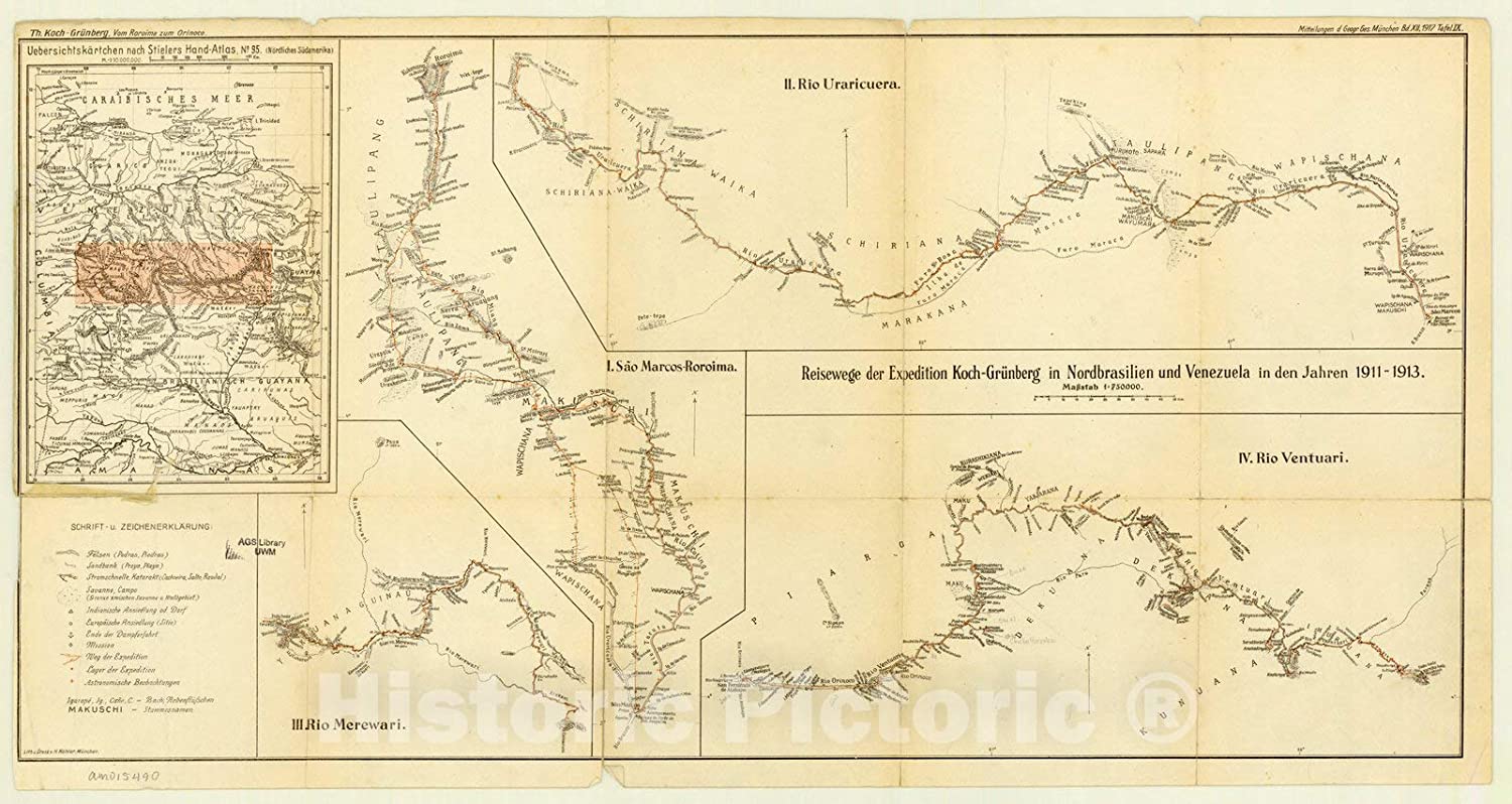
Dispossesions in the Americas

Dispossesions in the Americas

  • Home
  • Explore
  • About
  • Authors
  • Art
  • Bodies
  • Curricula
  • Cultural Heritage
  • Maps
  • Territories
Back to Explore
Map 1911 - 1913

Expedition Koch-Grunberg in Nordbrasilien und Venezuela in den Jahren 1911-1913

  • THEODOR KOCH-GRÜNBERG

Published: 1917

  • Download Image

Peoples

  • MAKUSHI
  • WAPISHANA
  • WAIKAS
  • YEKUANA
  • YAVARANA
  • CURACHICANAS
  • MAKU
  • PIAROA
  • TAULIPANG
  • WAYUMARA
  • MARAKANA
  • SCHIRIANA
  • IHURUANA
  • KUNUANA
  • DEKUANA

Citation

Koch-Grünberg;Theodor. "Reisewege der Expedition Koch-Grunberg in Nordbrasilien und Venezuela in den Jahren 1911-1913." Map. In Mitteilungen der Geographischen Gesellschaft in München. Vol. 12. Munich: Geographical Society of Munich;1917. Accessed March 3;2023. https://www.historicpictoric.com/products/map-brazil-1917-reisewege-der-expedition-kochgrunberg.

  • Download Image

Reading in Spanish

Map 1911 - 1913

Expedition Koch-Grunberg in Nordbrasilien und Venezuela in den Jahren 1911-1913

  • THEODOR KOCH-GRÜNBERG

Published: 1917

  • Download Image
  • Download Image

Reading in Portuguese

Map 1911 - 1913

Expedition Koch-Grunberg in Nordbrasilien und Venezuela in den Jahren 1911-1913

  • THEODOR KOCH-GRÜNBERG

Published: 1917

  • Download Image

Peoples

  • MAKUSHI
  • WAPISHANA
  • WAIKAS
  • YEKUANA
  • YAVARANA
  • CURACHICANAS
  • MAKU
  • PIAROA
  • TAULIPANG
  • WAYUMARA
  • MARAKANA
  • SCHIRIANA
  • IHURUANA
  • KUNUANA
  • DEKUANA

Citation

Koch-Grünberg;Theodor. "Reisewege der Expedition Koch-Grunberg in Nordbrasilien und Venezuela in den Jahren 1911-1913." Map. In Mitteilungen der Geographischen Gesellschaft in München. Vol. 12. Munich: Geographical Society of Munich;1917. Accessed March 3;2023. https://www.historicpictoric.com/products/map-brazil-1917-reisewege-der-expedition-kochgrunberg.

  • Download Image

Related Content

MUNICIPIOS CON JURISDICCION EN LA SIERRA NEVADA DE SANTA MARIA

MUNICIPIOS CON JURISDICCION EN LA SIERRA NEVADA DE SANTA MARIA

Map 2015
Explorations de la Guyane par Henri Coudreau, 1887-89, 1889-91.

Explorations de la Guyane par Henri Coudreau, 1887-89, 1889-91.

Map 1887 - 1891
Territorios donde viven descendientes de indígenas

Territorios donde viven descendientes de indígenas

Map 2010 - 2020
Guaná

Guaná

Map 2001
"Territorio Indígena Cabécar de Ujarrás"

"Territorio Indígena Cabécar de Ujarrás"

Map 2010
LIENZO OF SANTO TOMÁS OCOTEPEQUE

LIENZO OF SANTO TOMÁS OCOTEPEQUE

Map 1580
A Map of part of Yucatan or of that Part of the Eastern Shore Within the Bay of Honduras Alloted to Great Britain for the Cutting of Logwood, in consequence of the Convention Signed with Spain on the 14th July 1786.

A Map of part of Yucatan or of that Part of the Eastern Shore Within the Bay of Honduras Alloted to Great Britain for the Cutting of Logwood, in consequence of the Convention Signed with Spain on the 14th July 1786.

Map 1700
RELACIONES GEOGRÁFICAS DE OAXACA, TEHUANTEPEC

RELACIONES GEOGRÁFICAS DE OAXACA, TEHUANTEPEC

Map 1579 - 1585

Dispossessions in the Americas

A project by

University of Pennsylvania

Copyright 2024

With support from

Mellon Foundation

Site design & development

Element 84

Art Credits

Koch-Grünberg;Theodor. “Reisewege der Expedition Koch-Grunberg in Nordbrasilien und Venezuela in den Jahren 1911-1913.” Map. In Mitteilungen der Geographischen Gesellschaft in München. Vol. 12. Munich: Geographical Society of Munich;1917. Accessed March 3;2023. https://www.historicpictoric.com/products/map-brazil-1917-reisewege-der-expedition-kochgrunberg.

Site Pages

  • Home
  • Explore
  • About
  • Authors
  • Art
  • Bodies
  • Curricula
  • Cultural Heritage
  • Maps
  • Territories