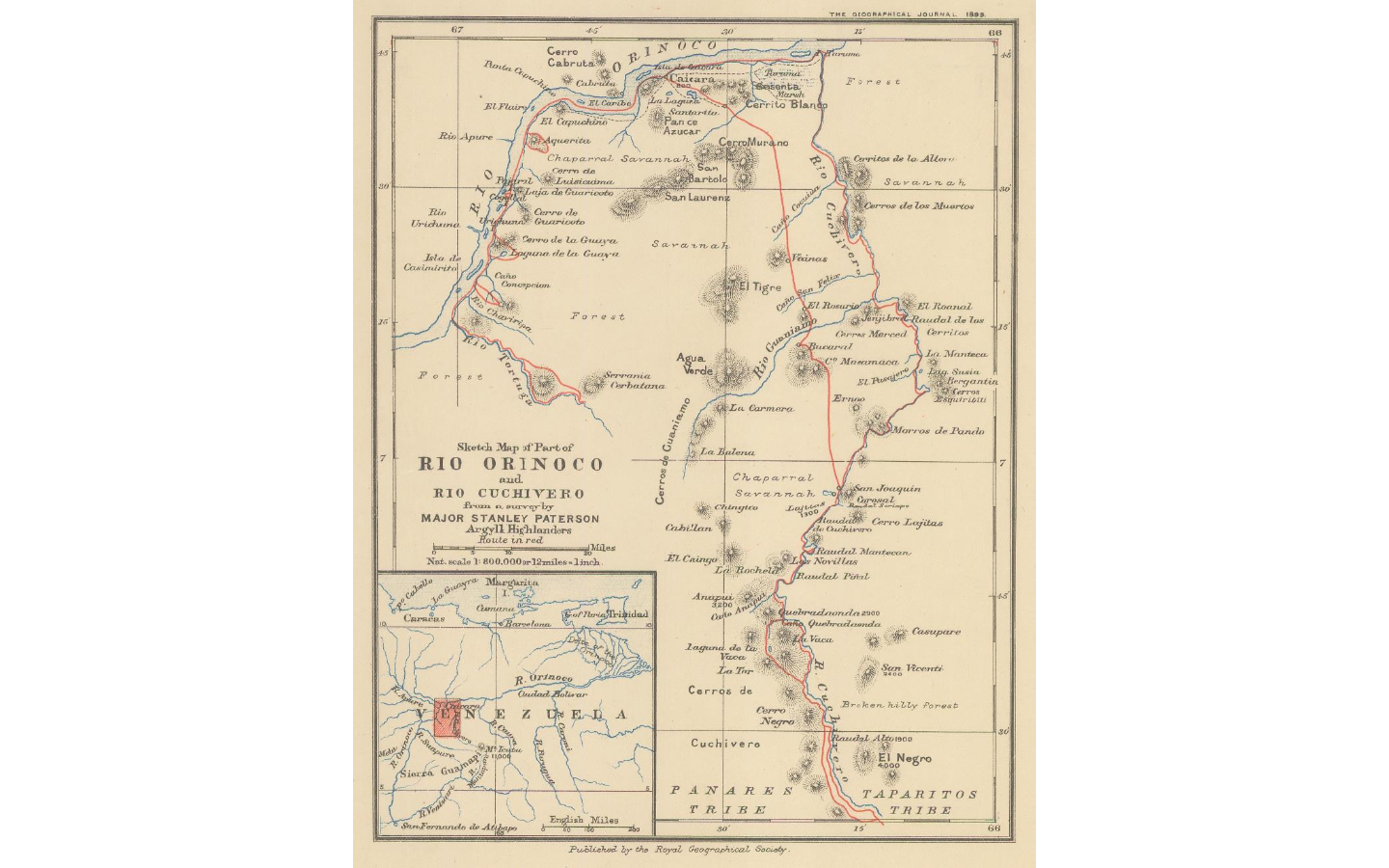
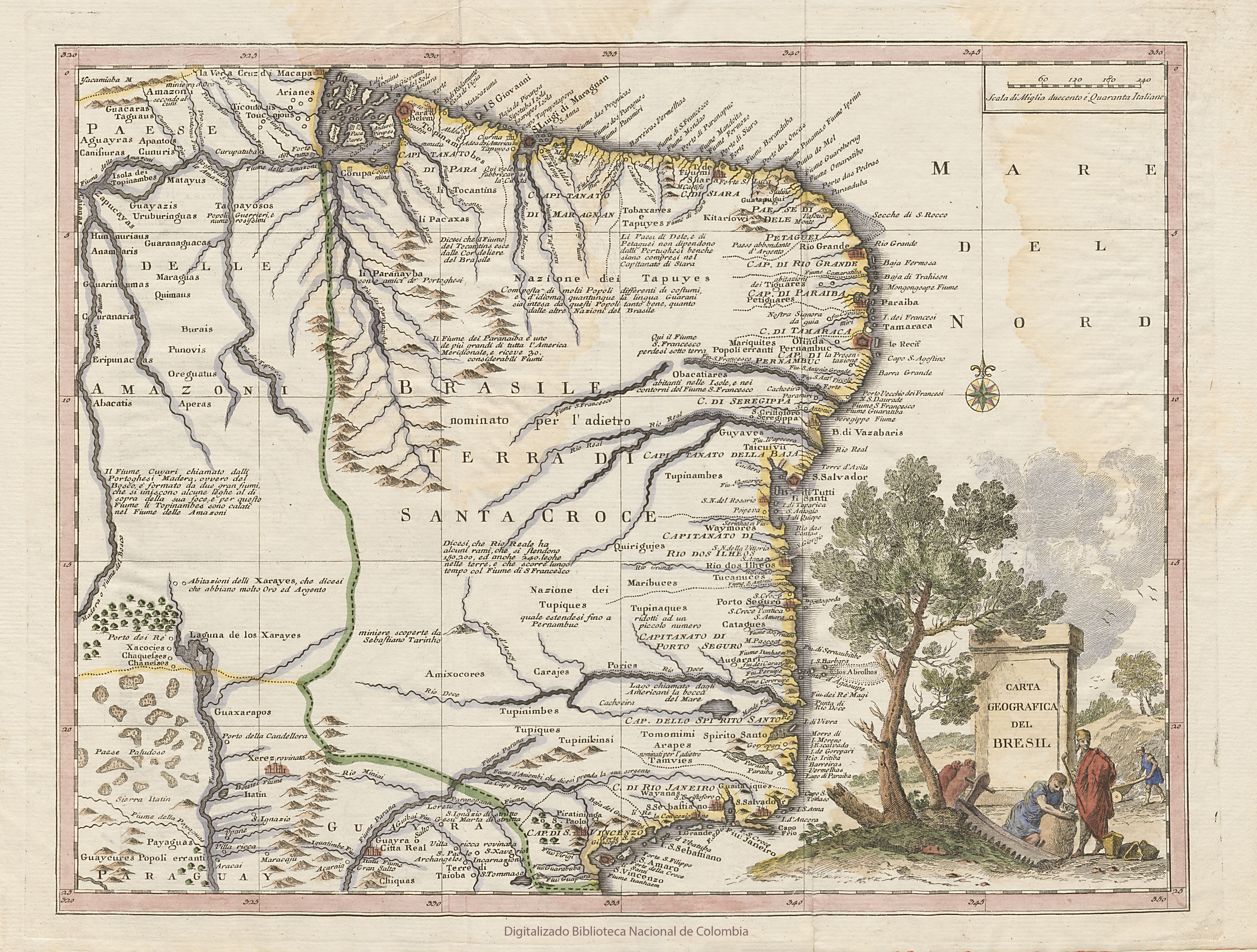
Dispossesions in the Americas

Dispossesions in the Americas

  • Home
  • Explore
  • About
  • Authors
  • Art
  • Bodies
  • Curricula
  • Cultural Heritage
  • Maps
  • Territories
Back to Explore
Map 1896

Sketch map of part of RÍO ORINOCO and RIO CUCHIVERO from a survey by MAJOR STANLEY PATERSON

    Published: 1899

    • Download Image

    Peoples

    • ENEPA
    • TAPARITAS

    Citation

    "Sketch map of part of Rio Orinoco and Rio Cuchivero from a survey by Major Stanley Paterson." Map. In The Geographical Journal. London: Royal Geographical Society;1899. Accessed February 26;2023. https://www.themaphouse.com/search_getamap.aspx?id=129676&ref=SAM3271.

    • Download Image

    Reading in Spanish

    Map 1896

    Sketch map of part of RÍO ORINOCO and RIO CUCHIVERO from a survey by MAJOR STANLEY PATERSON

      Published: 1899

      • Download Image
      • Download Image

      Related Content

      BRASIL

      BRASIL

      Map 1835
      Cette Carte de Californie et du Nouveau Mexique

      Cette Carte de Californie et du Nouveau Mexique

      Map 1705
      Amerique Meridionale

      Amerique Meridionale

      Map 1650
      LOCALIZACIÓN ACTUAL DE LAS PRINCIPALES FAMILIAS LINGÜÍSTICAS EN SURAMÉRICA

      LOCALIZACIÓN ACTUAL DE LAS PRINCIPALES FAMILIAS LINGÜÍSTICAS EN SURAMÉRICA

      Map 2000
      CARTE GÉOGRAPHIQUE, STATISTIQUE, HISTORIQUE ET POLITIQUE DU BRÉSIL

      CARTE GÉOGRAPHIQUE, STATISTIQUE, HISTORIQUE ET POLITIQUE DU BRÉSIL

      Map 1826
      Prehispanic Distribution of the Otomí Family

      Prehispanic Distribution of the Otomí Family

      Map 1969
      BRASILIA qua parte paret BELGIS

      BRASILIA qua parte paret BELGIS

      Map 1644
      Carte de la cote orientale Du Brésil entre le 15e et le 23e degré de latitude australe

      Carte de la cote orientale Du Brésil entre le 15e et le 23e degré de latitude australe

      Map 1821

      Dispossessions in the Americas

      A project by

      University of Pennsylvania

      Copyright 2024

      With support from

      Mellon Foundation

      Site design & development

      Element 84

      Art Credits

      “Sketch map of part of Rio Orinoco and Rio Cuchivero from a survey by Major Stanley Paterson.” Map. In The Geographical Journal. London: Royal Geographical Society;1899. Accessed February 26;2023. https://www.themaphouse.com/search_getamap.aspx?id=129676&ref=SAM3271.

      Site Pages

      • Home
      • Explore
      • About
      • Authors
      • Art
      • Bodies
      • Curricula
      • Cultural Heritage
      • Maps
      • Territories