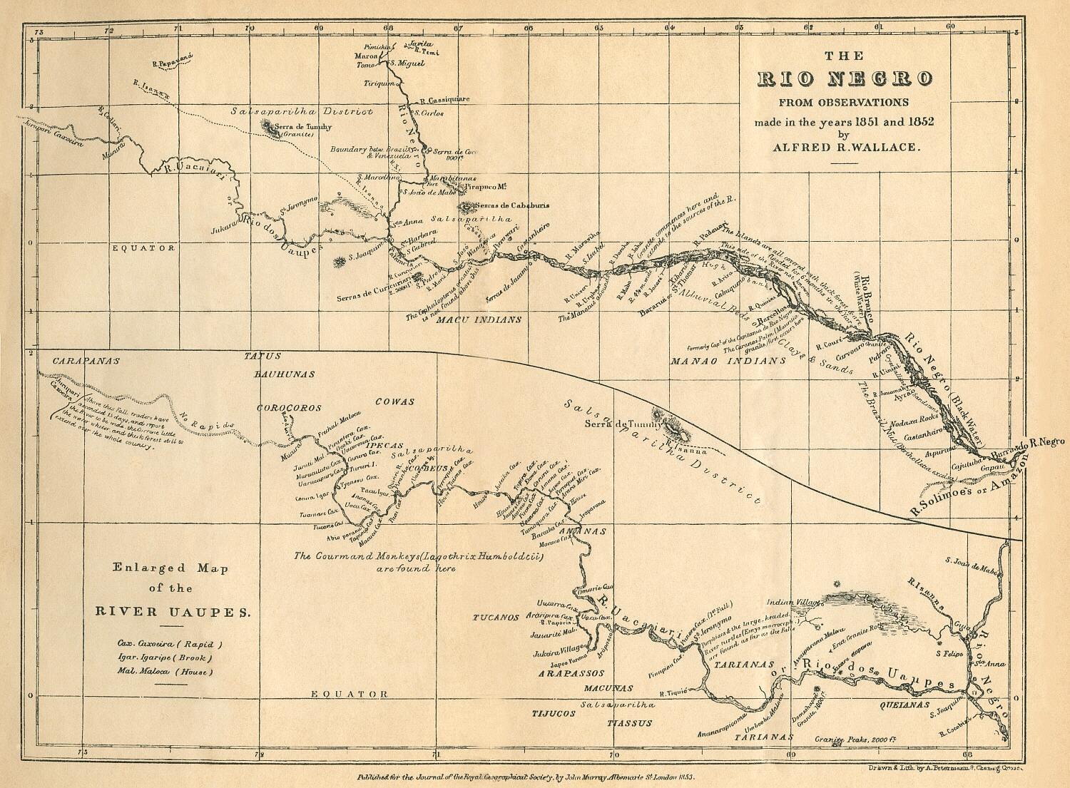
Dispossesions in the Americas

Dispossesions in the Americas

  • Home
  • Explore
  • About
  • Authors
  • Art
  • Bodies
  • Curricula
  • Cultural Heritage
  • Maps
  • Territories
Back to Explore
Map 1851 - 1852

THE RÍO NEGRO

  • WALLACE;ALFRED R

Published: 1853

  • Download Image

Peoples

  • MAJANAO
  • MAKU
  • CARAPANAS
  • TATUS
  • BAUHUNAS
  • COROCOROS
  • COWAS
  • TUCANOS
  • ARAPASSOS
  • TIJUCOS
  • MACUNAS
  • TIASSUS
  • TARIANAS
  • QUEIANAS

Citation

Wallace;Alfred R. The Rio Negro. Map. London: Journal of the Royal Geographical Society;1853. Accessed February 11;2023. https://people.wku.edu/charles.smith/wallace/S011.htm.

  • Download Image

Reading in Spanish

Map 1851 - 1852

THE RÍO NEGRO

  • WALLACE;ALFRED R

Published: 1853

  • Download Image
  • Download Image

Reading in Portuguese

Map 1851 - 1852

THE RÍO NEGRO

  • WALLACE;ALFRED R

Published: 1853

  • Download Image

Peoples

  • MAJANAO
  • MAKU
  • CARAPANAS
  • TATUS
  • BAUHUNAS
  • COROCOROS
  • COWAS
  • TUCANOS
  • ARAPASSOS
  • TIJUCOS
  • MACUNAS
  • TIASSUS
  • TARIANAS
  • QUEIANAS

Citation

Wallace;Alfred R. The Rio Negro. Map. London: Journal of the Royal Geographical Society;1853. Accessed February 11;2023. https://people.wku.edu/charles.smith/wallace/S011.htm.

  • Download Image

Related Content

Terra Indígena Vale do Javarí

Terra Indígena Vale do Javarí

Map 2000 - 2099
MAPA DE LA REGIÓN LIMÍTROFE ENTRE LA República de Colombia y los Estados Unidos de Brasil

MAPA DE LA REGIÓN LIMÍTROFE ENTRE LA República de Colombia y los Estados Unidos de Brasil

Map 1900 - 1999
Tribes of the Gran Chaco: Present day locations

Tribes of the Gran Chaco: Present day locations

Map 1946
CAMINOS DE MIGRACIÓN EN EL MONTE

CAMINOS DE MIGRACIÓN EN EL MONTE

Map 2003
ACTUAL TERRITORIO NUKAK

ACTUAL TERRITORIO NUKAK

Map 1978
America Meridionalis

America Meridionalis

Map 1619
Mapa del area lingüística de la lengua Xinka

Mapa del area lingüística de la lengua Xinka

Map 2015
Area de  las Poblaciones Lipez en Ollague antes de la Reduccion de 1602.

Area de las Poblaciones Lipez en Ollague antes de la Reduccion de 1602.

Map 1601

Dispossessions in the Americas

A project by

University of Pennsylvania

Copyright 2024

With support from

Mellon Foundation

Site design & development

Element 84

Art Credits

Wallace;Alfred R. The Rio Negro. Map. London: Journal of the Royal Geographical Society;1853. Accessed February 11;2023. https://people.wku.edu/charles.smith/wallace/S011.htm.

Site Pages

  • Home
  • Explore
  • About
  • Authors
  • Art
  • Bodies
  • Curricula
  • Cultural Heritage
  • Maps
  • Territories