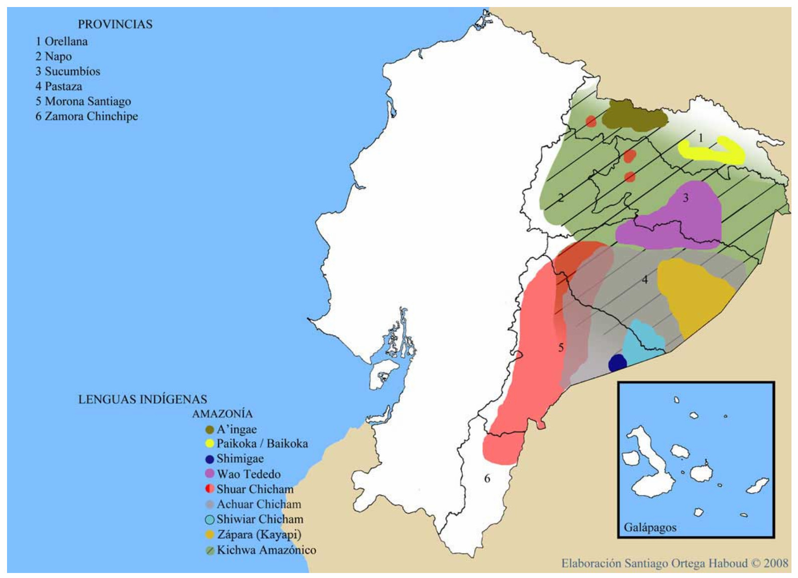
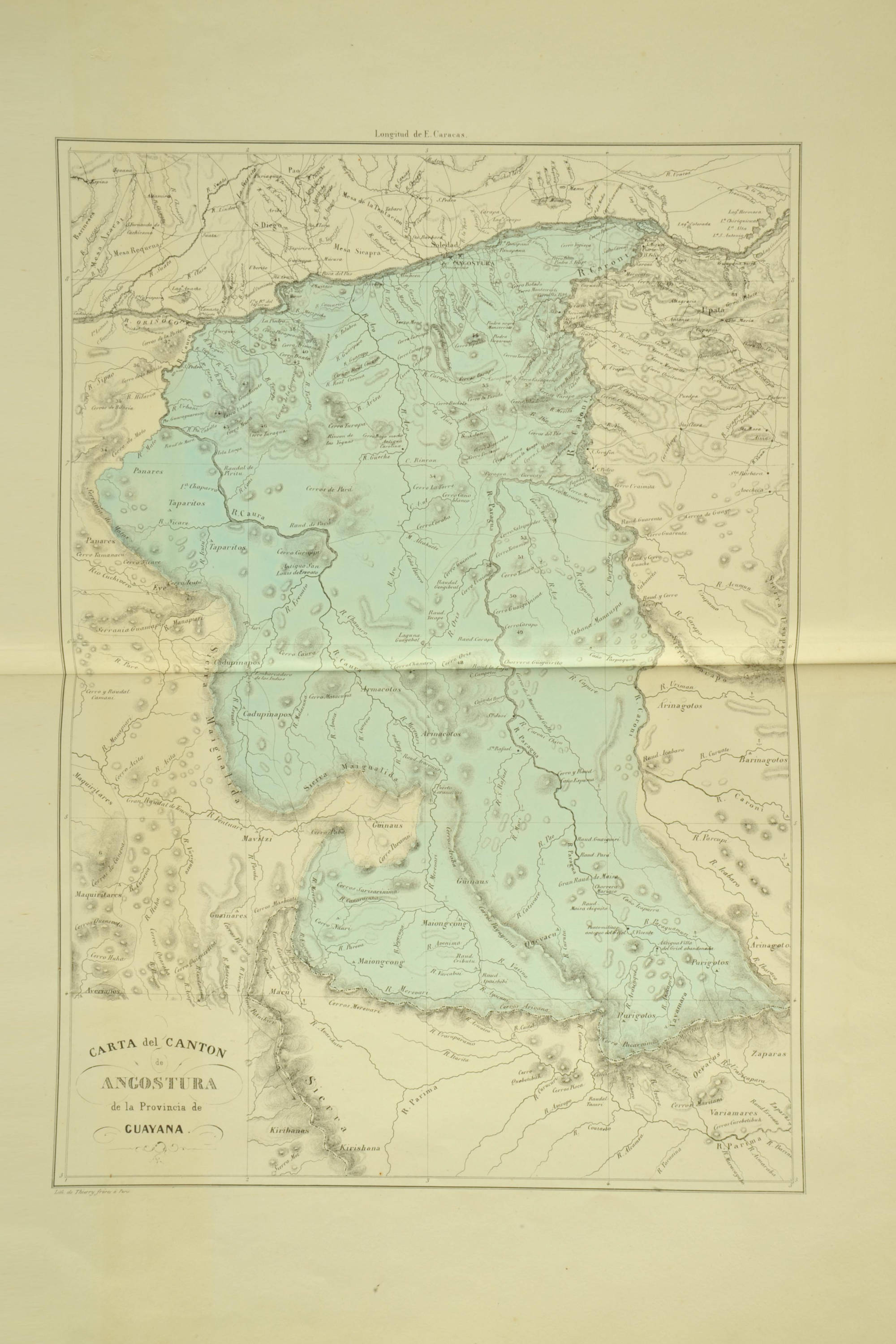
Dispossesions in the Americas

Dispossesions in the Americas

  • Home
  • Explore
  • About
  • Authors
  • Art
  • Bodies
  • Curricula
  • Cultural Heritage
  • Maps
  • Territories
Back to Explore
Map 1840

CARTA del CANTON de ANGOSTURA de la Provincia de GUAYANA

  • CODAZZI;AGUSTÍN

Published: 1840

  • Download Image

Peoples

  • ENEPA
  • TAPARITAS
  • ARNACOTO
  • PEMON
  • CADUPINAPOS
  • YEKUANA
  • GUAINARES
  • ABERIANA
  • MAVITZI
  • GUINAUS
  • MAIONGEONG
  • MAKU
  • QUEVACU
  • PURIGOTOS
  • ZAPARA
  • KIRISHANA
  • VARIAMARES

Citation

Codazzi;Agustín. Carta del cantón de Angostura de la provincia de Guayana. Map. Caracas;1840. Accessed February 2;2023. https://babel.banrepcultural.org/digital/collection/p17054coll13/id/127/rec/91.

  • Download Image

Reading in Spanish

Map 1840

CARTA del CANTON de ANGOSTURA de la Provincia de GUAYANA

  • CODAZZI;AGUSTÍN

Published: 1840

  • Download Image
  • Download Image

Reading in Portuguese

Map 1840

CARTA del CANTON de ANGOSTURA de la Provincia de GUAYANA

  • CODAZZI;AGUSTÍN

Published: 1840

  • Download Image

Peoples

  • ENEPA
  • TAPARITAS
  • ARNACOTO
  • PEMON
  • CADUPINAPOS
  • YEKUANA
  • GUAINARES
  • ABERIANA
  • MAVITZI
  • GUINAUS
  • MAIONGEONG
  • MAKU
  • QUEVACU
  • PURIGOTOS
  • ZAPARA
  • KIRISHANA
  • VARIAMARES

Citation

Codazzi;Agustín. Carta del cantón de Angostura de la provincia de Guayana. Map. Caracas;1840. Accessed February 2;2023. https://babel.banrepcultural.org/digital/collection/p17054coll13/id/127/rec/91.

  • Download Image

Related Content

Sanapaná

Sanapaná

Map 2001
Victoria regia [Giant Water Lily]

Victoria regia [Giant Water Lily]

Artwork
Rainha do Rio Niger [Queen of the Niger River]

Rainha do Rio Niger [Queen of the Niger River]

Artwork
LENGUAS INDIGENAS AMAZONIA

LENGUAS INDIGENAS AMAZONIA

Map 2008
Indian Riots and Rebellions in Guatemala, 1679-1825

Indian Riots and Rebellions in Guatemala, 1679-1825

Map 1679 - 1825
XI RONDA PETROLERA Y TERRITORIOS INDIGENAS

XI RONDA PETROLERA Y TERRITORIOS INDIGENAS

Map 2011
QOM

QOM

Map 2015
MAPA DE LA REPÚBLICA DEL PARAGUAY

MAPA DE LA REPÚBLICA DEL PARAGUAY

Map

Dispossessions in the Americas

A project by

University of Pennsylvania

Copyright 2024

With support from

Mellon Foundation

Site design & development

Element 84

Art Credits

Codazzi;Agustín. Carta del cantón de Angostura de la provincia de Guayana. Map. Caracas;1840. Accessed February 2;2023. https://babel.banrepcultural.org/digital/collection/p17054coll13/id/127/rec/91.

Site Pages

  • Home
  • Explore
  • About
  • Authors
  • Art
  • Bodies
  • Curricula
  • Cultural Heritage
  • Maps
  • Territories