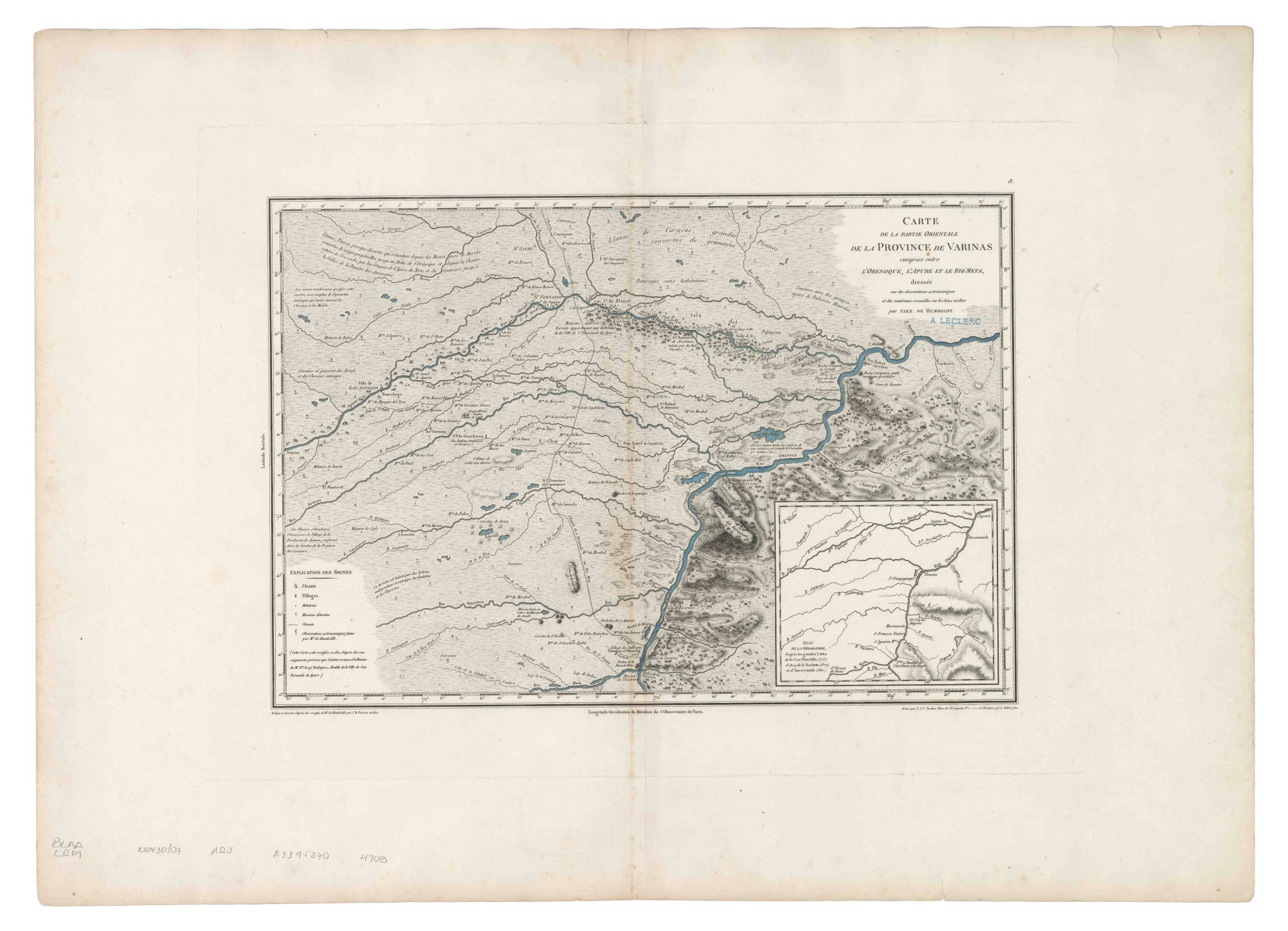
Dispossesions in the Americas

Dispossesions in the Americas

  • Home
  • Explore
  • About
  • Authors
  • Art
  • Bodies
  • Curricula
  • Cultural Heritage
  • Maps
  • Territories
Back to Explore
Map 1800

Carte de la Partie Orientale de la Province de Varinas comprise entre L'Orenoque;L'Apure et le Rio Meta

  • POIRSON;JEAN BAPTISTE

Published: 1812

  • Download Image

Peoples

  • OTOMACO
  • YARURO
  • JIVI
  • CHIRICOA
  • GUARICOTO
  • GUAMOS

Citation

Poirson;Jean Baptiste. "Carte de la Partie Orientale de la Province de Varinas comprise entre L'Orenoque;L'Apure et le Rio Meta." Map. 1812. Accessed January 22;2023. https://babel.banrepcultural.org/digital/collection/p17054coll13/id/71/rec/9.

  • Download Image

Reading in Spanish

Map 1800

Carte de la Partie Orientale de la Province de Varinas comprise entre L'Orenoque;L'Apure et le Rio Meta

  • POIRSON;JEAN BAPTISTE

Published: 1812

  • Download Image
  • Download Image

Related Content

PUEBLO OCAINA

PUEBLO OCAINA

Map 2021
MAP SHOWING SACRED PLACES VISITED BY THE HUICHOL INDIANS

MAP SHOWING SACRED PLACES VISITED BY THE HUICHOL INDIANS

Map 1902
Lengua Muerta [Dead Languague]

Lengua Muerta [Dead Languague]

Artwork
MAP 7.—The Highland tribes of Colombia and Ecuador. (Drawn from data compiled by Gregorio Hernández de Alba;John Murra;Sergio Elías Ortíz;and Henri Lehmann.)

MAP 7.—The Highland tribes of Colombia and Ecuador. (Drawn from data compiled by Gregorio Hernández de Alba;John Murra;Sergio Elías Ortíz;and Henri Lehmann.)

Map 1400
Distribución  de  los  Grupos  Indígenas  de Bolivia

Distribución de los Grupos Indígenas de Bolivia

Map 2000 - 2010
Geographic Distribution of the Amuzgo

Geographic Distribution of the Amuzgo

Map 1969
Paskaerte vande cust van Westindien van R. Desaguadera tot C. de Honduras / beschreven door Arent Roggeveen

Paskaerte vande cust van Westindien van R. Desaguadera tot C. de Honduras / beschreven door Arent Roggeveen

Map 1675
DESCRIPCIÓN GEOGRÁFICA DEL RIO MAMORE O MADERA EN LA AMERICA AUSTRAL DEL DOMINIO DE LA CORONA ESPAÑOLA

DESCRIPCIÓN GEOGRÁFICA DEL RIO MAMORE O MADERA EN LA AMERICA AUSTRAL DEL DOMINIO DE LA CORONA ESPAÑOLA

Map 1782

Dispossessions in the Americas

A project by

University of Pennsylvania

Copyright 2024

With support from

Mellon Foundation

Site design & development

Element 84

Art Credits

Poirson;Jean Baptiste. “Carte de la Partie Orientale de la Province de Varinas comprise entre L’Orenoque;L’Apure et le Rio Meta.” Map. 1812. Accessed January 22;2023. https://babel.banrepcultural.org/digital/collection/p17054coll13/id/71/rec/9.

Site Pages

  • Home
  • Explore
  • About
  • Authors
  • Art
  • Bodies
  • Curricula
  • Cultural Heritage
  • Maps
  • Territories