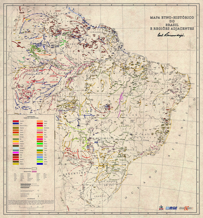
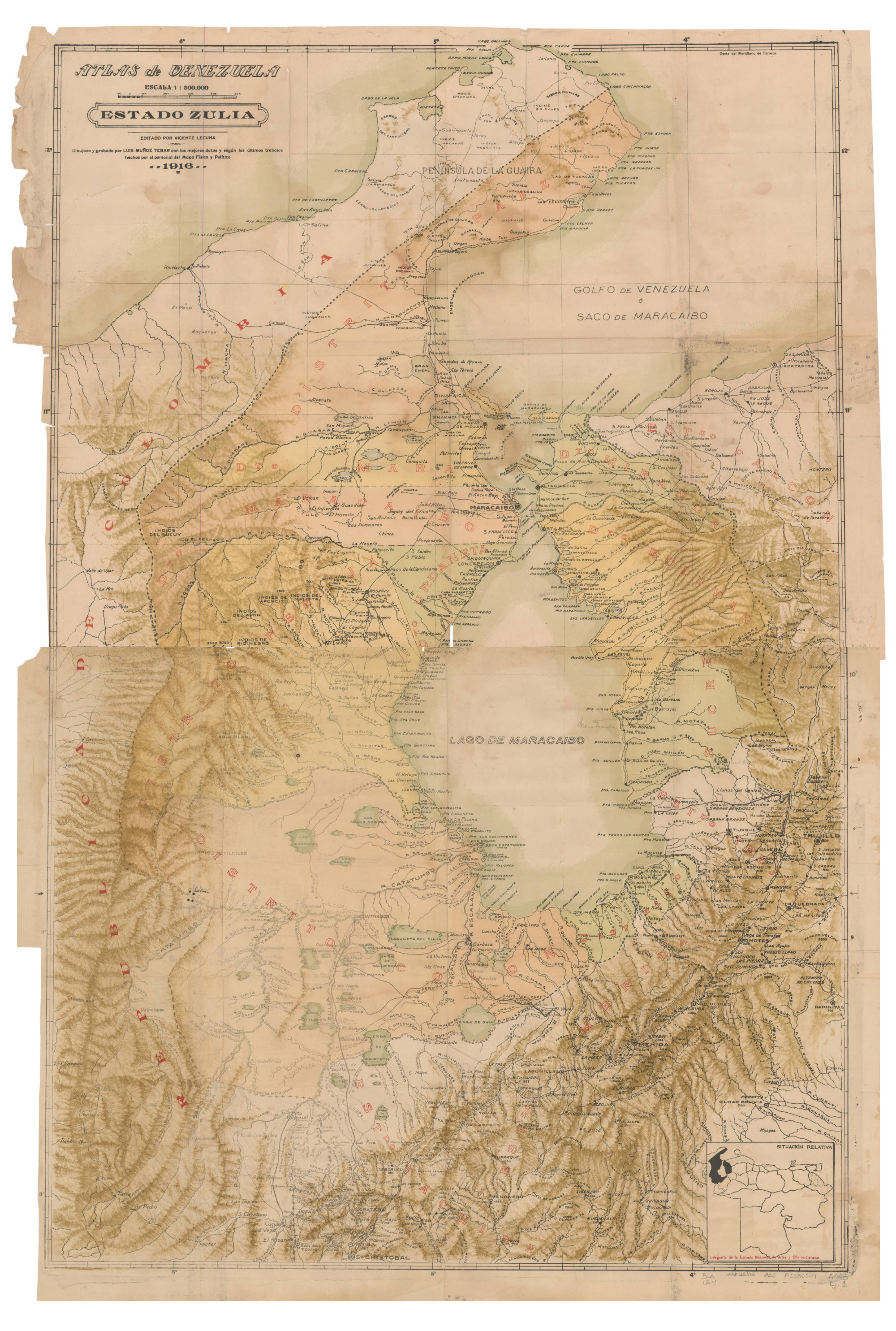
Dispossesions in the Americas

Dispossesions in the Americas

  • Home
  • Explore
  • About
  • Authors
  • Art
  • Bodies
  • Curricula
  • Cultural Heritage
  • Maps
  • Territories
Back to Explore
Map 1916

ATLAS de VENEZUELA ESTADO ZULIA

  • MUNOZ TEBAR;LUIS

Published: 1916

  • Download Image

Peoples

  • EPIEVUES
  • PUSHAINAS
  • INDIOS DEL SUCUY
  • INDIOS DE APONCITO
  • INDIOS DEL MACOITA
  • INDIOS DEL APON
  • INDIOS DEL RIO NEGRO
  • INDIOS DE ARIGUISA
  • INDIOS DE ABIA BLANCA
  • INDIOS TOCUCOS
  • INDIOS PARIRIES
  • COSINAS
  • BARI
  • APUANAS
  • JUSAVUES

Citation

Muñoz Tebar;Luis. "Atlas de Venezuela. Estado Zulia." Map. 1916. Accessed January 22;2023. https://babel.banrepcultural.org/digital/collection/p17054coll13/id/541/rec/14.

  • Download Image

Reading in Spanish

Map 1916

ATLAS de VENEZUELA ESTADO ZULIA

  • MUNOZ TEBAR;LUIS

Published: 1916

  • Download Image
  • Download Image

Reading in Portuguese

Map 1916

ATLAS de VENEZUELA ESTADO ZULIA

  • MUNOZ TEBAR;LUIS

Published: 1916

  • Download Image

Peoples

  • EPIEVUES
  • PUSHAINAS
  • INDIOS DEL SUCUY
  • INDIOS DE APONCITO
  • INDIOS DEL MACOITA
  • INDIOS DEL APON
  • INDIOS DEL RIO NEGRO
  • INDIOS DE ARIGUISA
  • INDIOS DE ABIA BLANCA
  • INDIOS TOCUCOS
  • INDIOS PARIRIES
  • COSINAS
  • BARI
  • APUANAS
  • JUSAVUES

Citation

Muñoz Tebar;Luis. "Atlas de Venezuela. Estado Zulia." Map. 1916. Accessed January 22;2023. https://babel.banrepcultural.org/digital/collection/p17054coll13/id/541/rec/14.

  • Download Image

Related Content

THE KARANQAS AYMARA POLITY - Instant shot of trans-border connections around 1900 (Google Earth adaptation)

THE KARANQAS AYMARA POLITY - Instant shot of trans-border connections around 1900 (Google Earth adaptation)

Map 1860 - 1930
Mapa etno-histórico do Brazil e regiões adjacentes

Mapa etno-histórico do Brazil e regiões adjacentes

Map 1400 - 1944
AL SERMO FERDINANDO II GRANDVCA DI TOSCANA

AL SERMO FERDINANDO II GRANDVCA DI TOSCANA

Map 1661
Cartes de la Guyane. Carte de la Guyane Drançaise. Dressée sur l'ordre de M.e M. E. Picanon Gouverneur.

Cartes de la Guyane. Carte de la Guyane Drançaise. Dressée sur l'ordre de M.e M. E. Picanon Gouverneur.

Map 1907
Indigenous peoples of the coast of Brazil, (c. 16th C.)

Indigenous peoples of the coast of Brazil, (c. 16th C.)

Map 1500 - 1599
Entrée des rivières d'Ouyapoco et de Couripi.

Entrée des rivières d'Ouyapoco et de Couripi.

Map 1764
REGIÓN HUICOT O GRAN NAYAR

REGIÓN HUICOT O GRAN NAYAR

Map 2000
NATIVE RACES of the PACIFIC STATES

NATIVE RACES of the PACIFIC STATES

Map 1800

Dispossessions in the Americas

A project by

University of Pennsylvania

Copyright 2024

With support from

Mellon Foundation

Site design & development

Element 84

Art Credits

Muñoz Tebar;Luis. “Atlas de Venezuela. Estado Zulia.” Map. 1916. Accessed January 22;2023. https://babel.banrepcultural.org/digital/collection/p17054coll13/id/541/rec/14.

Site Pages

  • Home
  • Explore
  • About
  • Authors
  • Art
  • Bodies
  • Curricula
  • Cultural Heritage
  • Maps
  • Territories