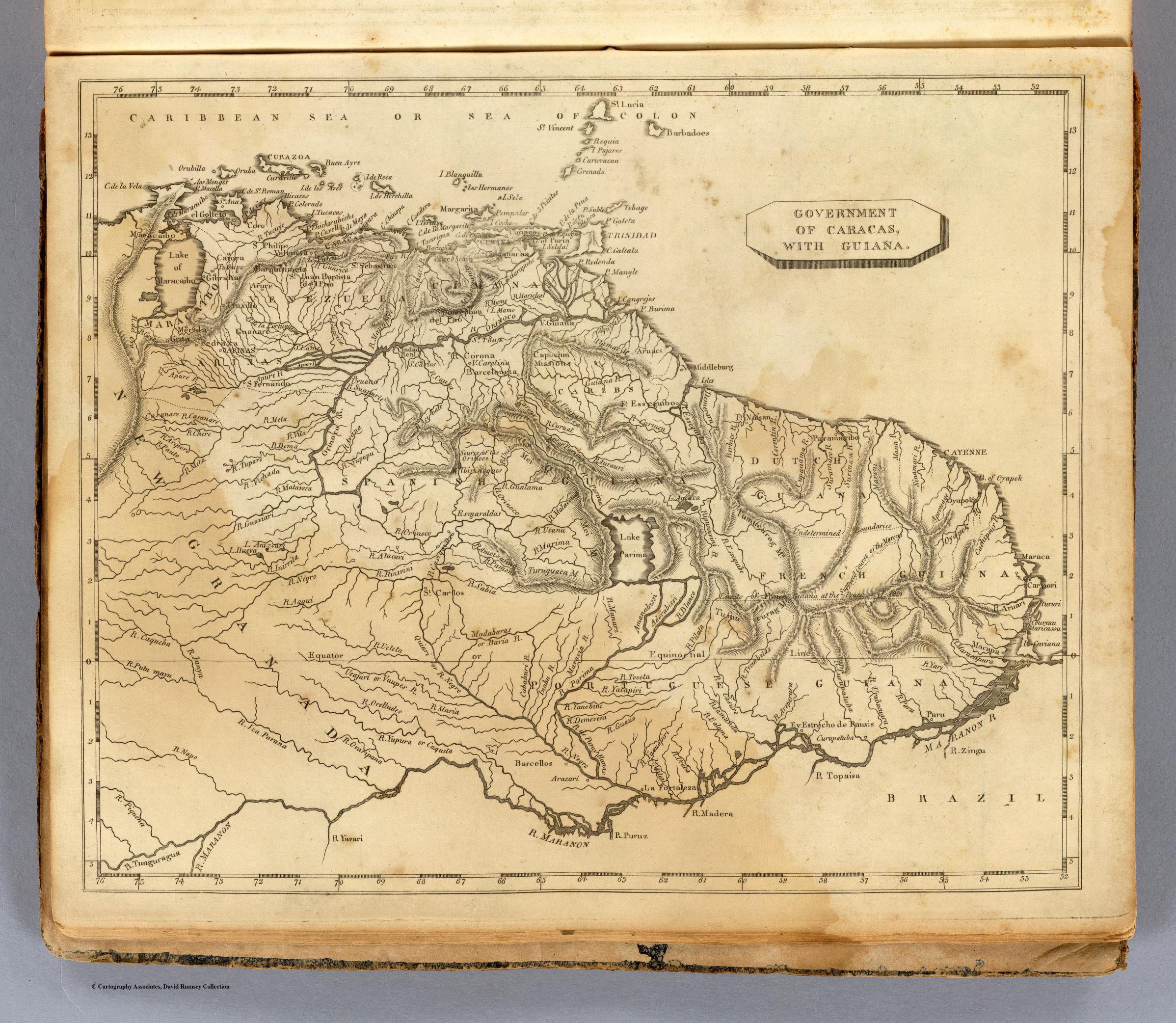
Dispossesions in the Americas

Dispossesions in the Americas

  • Home
  • Explore
  • About
  • Authors
  • Art
  • Bodies
  • Curricula
  • Cultural Heritage
  • Maps
  • Territories
Back to Explore
Map 1812

GOVERNMENT OF CARACAS;WITH GUIANA.

  • ARROWSMITH;AARON;ET AL.

Published: 1812

  • Download Image

Peoples

  • CARIBE
  • ARUACA

Citation

Lewis;Samuel. Caracas;Guiana. Map. Boston: Thomas & Andrews;1812. Accessed September 11;2022. https://www.davidrumsey.com/luna/servlet/detail/RUMSEY~8~1~31720~1150515:Caracas;-Guiana-?sort=pub_list_no_initialsort%2Cpub_date%2Cpub_list_no%2Cseries_no#.

  • Download Image

Reading in Spanish

Map 1812

GOVERNMENT OF CARACAS;WITH GUIANA.

  • ARROWSMITH;AARON;ET AL.

Published: 1812

  • Download Image
  • Download Image

Reading in Portuguese

Map 1812

GOVERNMENT OF CARACAS;WITH GUIANA.

  • ARROWSMITH;AARON;ET AL.

Published: 1812

  • Download Image

Peoples

  • CARIBE
  • ARUACA

Citation

Lewis;Samuel. Caracas;Guiana. Map. Boston: Thomas & Andrews;1812. Accessed September 11;2022. https://www.davidrumsey.com/luna/servlet/detail/RUMSEY~8~1~31720~1150515:Caracas;-Guiana-?sort=pub_list_no_initialsort%2Cpub_date%2Cpub_list_no%2Cseries_no#.

  • Download Image

Related Content

Mapa de las Comunidades Indígenas en el Paraguay

Mapa de las Comunidades Indígenas en el Paraguay

Map 2004
PUEBLOS INDIGENAS

PUEBLOS INDIGENAS

Map 2021
REGIÓN CHIMALAPAS

REGIÓN CHIMALAPAS

Map 2000
CARTA DEL DEPARTAMENTO DEL ORINOCO O DE MATURIN

CARTA DEL DEPARTAMENTO DEL ORINOCO O DE MATURIN

Map 1827
Mapa por despacho de Vice-ministerios

Mapa por despacho de Vice-ministerios

Map 2012
Prehispanic Distribution of the Otomí Family

Prehispanic Distribution of the Otomí Family

Map 1969
Detail from the 1770 copy of Francisco Álvarez Barreiro’s 1728 map of northern New Spain illustrating Spanish mapping of Indian domains in southern Texas and along the Gulf Coast, especially through the repetition of labels: “tierra de los Pampopas,” “tierra de los Carrizos,” “tierra de los Cujanes,” etc.

Detail from the 1770 copy of Francisco Álvarez Barreiro’s 1728 map of northern New Spain illustrating Spanish mapping of Indian domains in southern Texas and along the Gulf Coast, especially through the repetition of labels: “tierra de los Pampopas,” “tierra de los Carrizos,” “tierra de los Cujanes,” etc.

Map 1728
Bedxe´Guie´ [Sacred Land]

Bedxe´Guie´ [Sacred Land]

Artwork

Dispossessions in the Americas

A project by

University of Pennsylvania

Copyright 2024

With support from

Mellon Foundation

Site design & development

Element 84

Art Credits

Lewis;Samuel. Caracas;Guiana. Map. Boston: Thomas & Andrews;1812. Accessed September 11;2022. https://www.davidrumsey.com/luna/servlet/detail/RUMSEY~8~1~31720~1150515:Caracas;-Guiana-?sort=pub_list_no_initialsort%2Cpub_date%2Cpub_list_no%2Cseries_no#.

Site Pages

  • Home
  • Explore
  • About
  • Authors
  • Art
  • Bodies
  • Curricula
  • Cultural Heritage
  • Maps
  • Territories