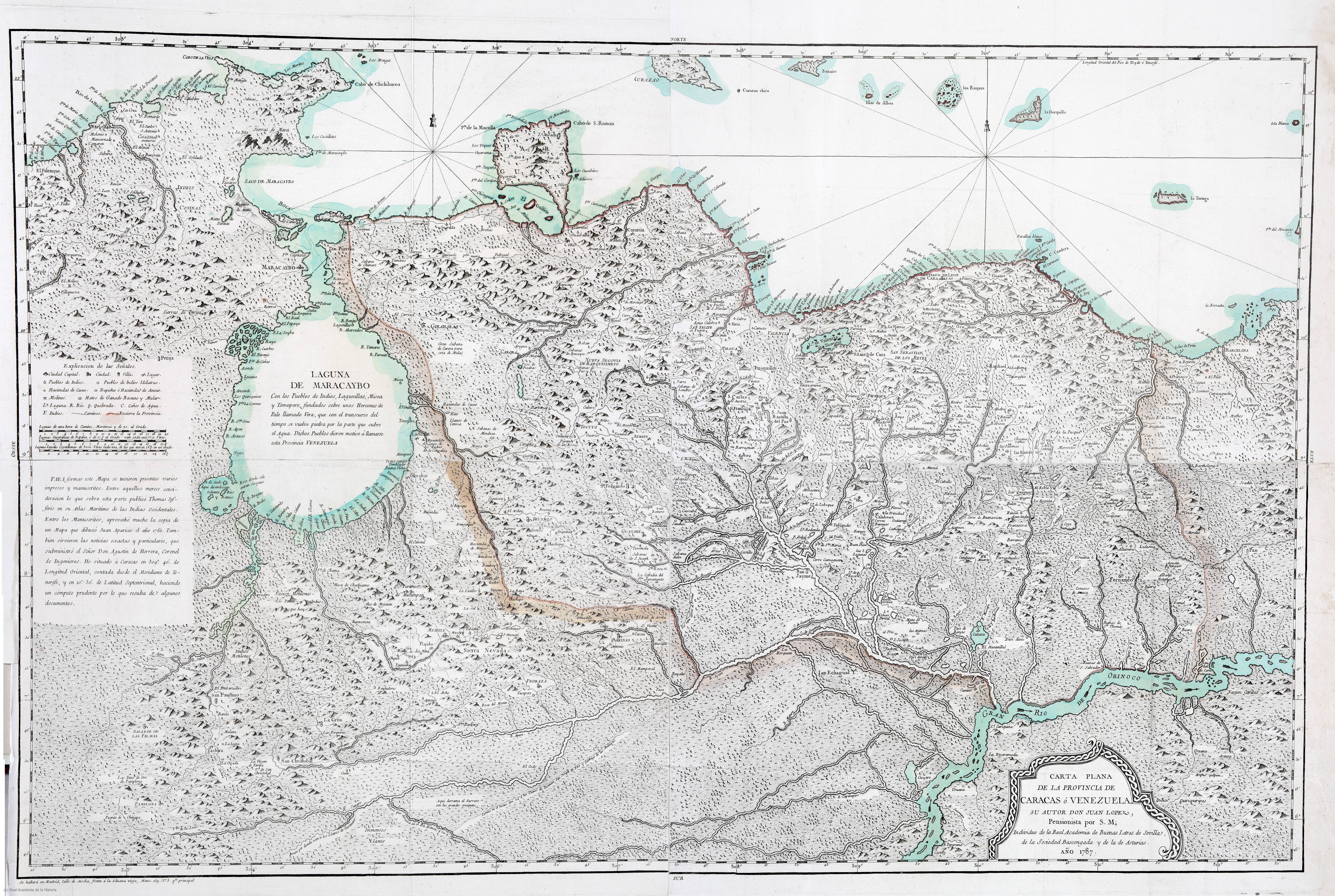
Dispossesions in the Americas

Dispossesions in the Americas

  • Home
  • Explore
  • About
  • Authors
  • Art
  • Bodies
  • Curricula
  • Cultural Heritage
  • Maps
  • Territories
Back to Explore
Map 1787

CARTA PLANA DE LA PROVINCIA DE CARACAS Ó VENEZUELA

  • LOPEZ;JUAN

Published: 1787

  • Download Image

Peoples

  • BARI
  • JIRAJARA
  • ACHAGUA
  • QUIRIQUIRES
  • QUIRIQUIRIPAS
  • CARIBES
  • ZAPARA
  • INDIOS COSINAS

Citation

Lopez;Juan. Carta Plana de la provincia de Caracas ó Venezuela. Map. Madrid;1787. Accessed August 21;2022. https://bvpb.mcu.es/es/catalogo_imagenes/grupo.do?path=155585.

  • Download Image

Reading in Spanish

Map 1787

CARTA PLANA DE LA PROVINCIA DE CARACAS Ó VENEZUELA

  • LOPEZ;JUAN

Published: 1787

  • Download Image
  • Download Image

Reading in Portuguese

Map 1787

CARTA PLANA DE LA PROVINCIA DE CARACAS Ó VENEZUELA

  • LOPEZ;JUAN

Published: 1787

  • Download Image

Peoples

  • BARI
  • JIRAJARA
  • ACHAGUA
  • QUIRIQUIRES
  • QUIRIQUIRIPAS
  • CARIBES
  • ZAPARA
  • INDIOS COSINAS

Citation

Lopez;Juan. Carta Plana de la provincia de Caracas ó Venezuela. Map. Madrid;1787. Accessed August 21;2022. https://bvpb.mcu.es/es/catalogo_imagenes/grupo.do?path=155585.

  • Download Image

Related Content

LA GRAN CIVDAD I CAVEsa y corte rreal de los doze rreys Yngas, Santiago del Cuzco en medio del rreyno y obispado

LA GRAN CIVDAD I CAVEsa y corte rreal de los doze rreys Yngas, Santiago del Cuzco en medio del rreyno y obispado

Map 1615
La Guyane française : Ses limited de 1814, d'après la carte de Leblond.

La Guyane française : Ses limited de 1814, d'après la carte de Leblond.

Map 1814
PUEBLO SERI

PUEBLO SERI

Map 2020
LOCALIZACION GEOGRAFICA DE LAS COMUNIDADES CIMARRONAS EN COLOMBIA DURANTE LOS SIGLOS XVI Y XVII

LOCALIZACION GEOGRAFICA DE LAS COMUNIDADES CIMARRONAS EN COLOMBIA DURANTE LOS SIGLOS XVI Y XVII

Map 1500 - 1699
CAPITANIARUM DE PHERNAMBUCA, ITAMARACA, PARAIBA ET RIO GRANDE NOVA DELINEATIO

CAPITANIARUM DE PHERNAMBUCA, ITAMARACA, PARAIBA ET RIO GRANDE NOVA DELINEATIO

Map 1650
GUARANÍ ÑANDÉVA

GUARANÍ ÑANDÉVA

Map 2015
Orí Odé

Orí Odé

Artwork
BRASIL

BRASIL

Map 1800 - 1899

Dispossessions in the Americas

A project by

University of Pennsylvania

Copyright 2024

With support from

Mellon Foundation

Site design & development

Element 84

Art Credits

Lopez;Juan. Carta Plana de la provincia de Caracas ó Venezuela. Map. Madrid;1787. Accessed August 21;2022. https://bvpb.mcu.es/es/catalogo_imagenes/grupo.do?path=155585.

Site Pages

  • Home
  • Explore
  • About
  • Authors
  • Art
  • Bodies
  • Curricula
  • Cultural Heritage
  • Maps
  • Territories