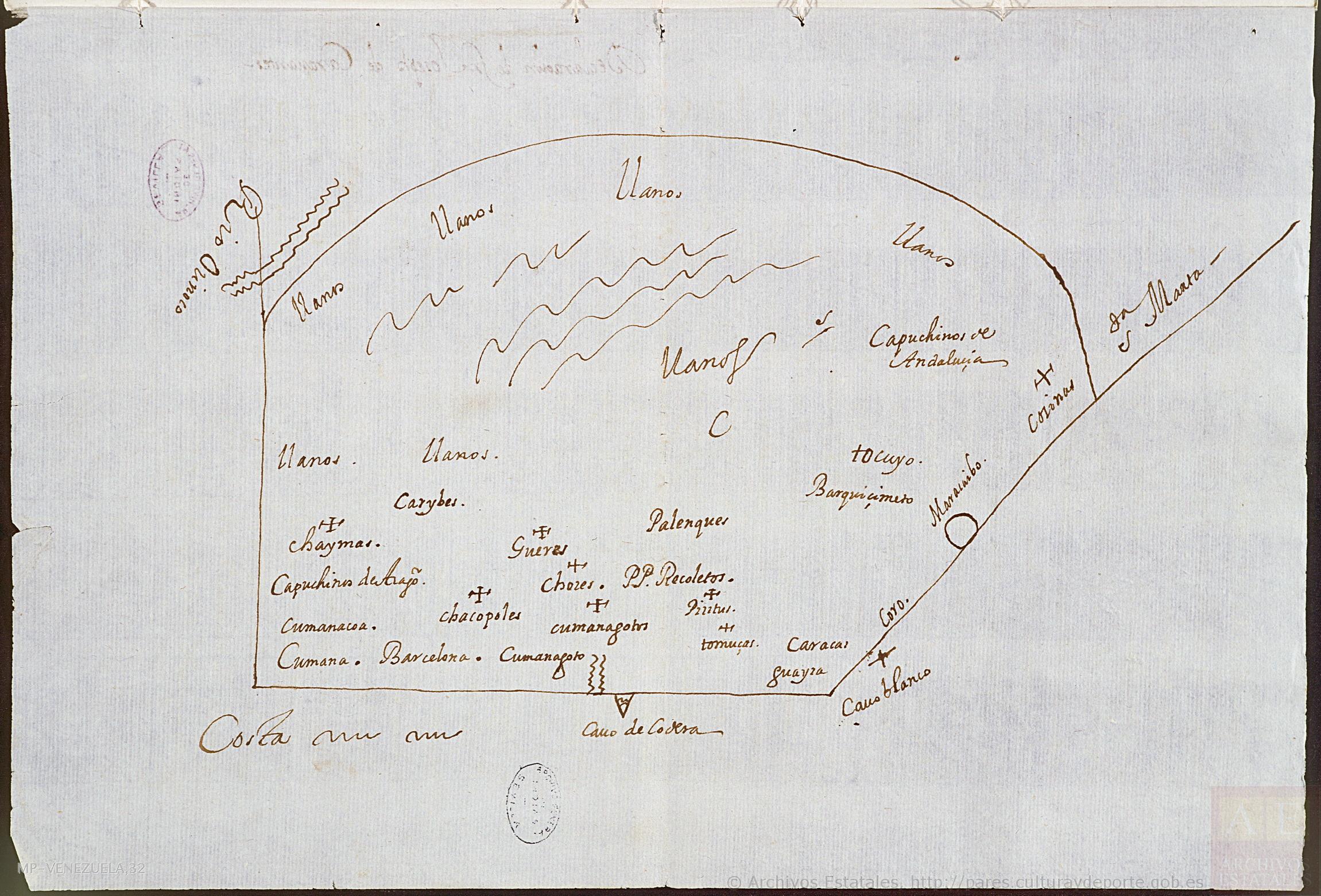
Dispossesions in the Americas

Dispossesions in the Americas

  • Home
  • Explore
  • About
  • Authors
  • Art
  • Bodies
  • Curricula
  • Cultural Heritage
  • Maps
  • Territories
Back to Explore
Map 1647

No Title

    Published: 1647

    • Download Image

    Peoples

    • CARIBE
    • CHAIMAS
    • CHACOPOLES
    • GUERES
    • CHORES
    • TOMUZAS
    • KUMANAGOTOS
    • PIRITUGOTOS
    • TOCUYOS

    Citation

    "Diseño de las misiones capuchinas comprendidas entre Cumaná y Caracas." Map. 1647. Accessed August 19;2022. http://pares.mcu.es/ParesBusquedas20/catalogo/description/25942.

    • Download Image

    Reading in Spanish

    Map 1647

    No Title

      Published: 1647

      • Download Image
      • Download Image

      Reading in Portuguese

      Map 1647

      No Title

        Published: 1647

        • Download Image

        Peoples

        • CARIBE
        • CHAIMAS
        • CHACOPOLES
        • GUERES
        • CHORES
        • TOMUZAS
        • KUMANAGOTOS
        • PIRITUGOTOS
        • TOCUYOS

        Citation

        "Diseño de las misiones capuchinas comprendidas entre Cumaná y Caracas." Map. 1647. Accessed August 19;2022. http://pares.mcu.es/ParesBusquedas20/catalogo/description/25942.

        • Download Image

        Related Content

        Estado eclesiástico, político y militar de la América (o grandeza de las Indias)

        Estado eclesiástico, político y militar de la América (o grandeza de las Indias)

        Map 1683
        AMAZONIA;TERRAFIRMA;Part of BRASIL and PERÚ

        AMAZONIA;TERRAFIRMA;Part of BRASIL and PERÚ

        Map 1735
        An exact draught of the Gulf of Darien & the coast to Porto Bello with Panama in the South sea & the Scotch settlement in Calledonia

        An exact draught of the Gulf of Darien & the coast to Porto Bello with Panama in the South sea & the Scotch settlement in Calledonia

        Map 1700 - 1799
        Guarani Retã 2008: Pueblos Guaraníes en las fronteras Argentina, Brasil y Paraguay

        Guarani Retã 2008: Pueblos Guaraníes en las fronteras Argentina, Brasil y Paraguay

        Map 2008
        BLACK LINE DECREE: SIERRA NEVADA DE SANTA MARTA

        BLACK LINE DECREE: SIERRA NEVADA DE SANTA MARTA

        Map 2018
        La Guyane française et le territoire de l'Inini.

        La Guyane française et le territoire de l'Inini.

        Map 1933
        TERRITORIO TEÄRIME SIRI’KOI AERIME SUITITI

        TERRITORIO TEÄRIME SIRI’KOI AERIME SUITITI

        Map 2012
        Theories of Indigenous “Habitat”.

        Theories of Indigenous “Habitat”.

        Map 1680 - 1805

        Dispossessions in the Americas

        A project by

        University of Pennsylvania

        Copyright 2024

        With support from

        Mellon Foundation

        Site design & development

        Element 84

        Art Credits

        “Diseño de las misiones capuchinas comprendidas entre Cumaná y Caracas.” Map. 1647. Accessed August 19;2022. http://pares.mcu.es/ParesBusquedas20/catalogo/description/25942.

        Site Pages

        • Home
        • Explore
        • About
        • Authors
        • Art
        • Bodies
        • Curricula
        • Cultural Heritage
        • Maps
        • Territories