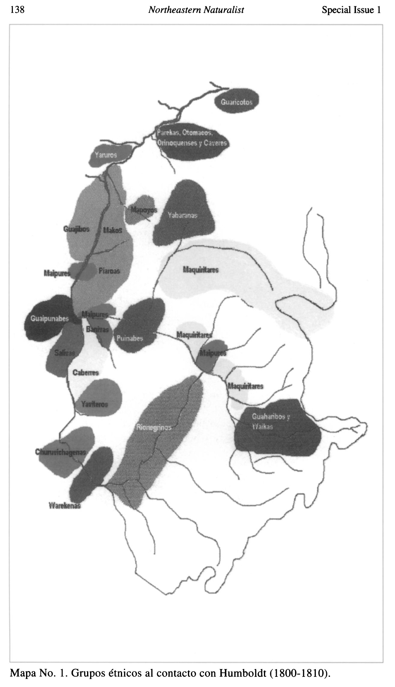
Dispossesions in the Americas

Dispossesions in the Americas

  • Home
  • Explore
  • About
  • Authors
  • Art
  • Bodies
  • Curricula
  • Cultural Heritage
  • Maps
  • Territories
Back to Explore
Map 1800 - 1810

Grupos étnicos al contacto con Humboldt (1800-1810)

  • DEOGENES EDGILDO PALAU;GEOG.

Published: 1999

  • Download Image

Peoples

  • GUARICOTOS
  • PAREKAS
  • OTOMACOS
  • ORINOQUENSES
  • CAVERES
  • YARUROS
  • MAPOYOS
  • YABARANAS
  • GUAJIBOS
  • MAKOS
  • MAIPURES
  • PIAROAS
  • MAQUIRITARES
  • GUAIPUNABES
  • BANIVAS
  • PUNIABES
  • SALIVAS
  • CABERRES YAVITEROS
  • CHURUVICHAGENAS
  • WAREKENAS
  • RIONEGRINAS
  • GUAHARIBOS
  • WAIKAS

Citation

Palau;Geóg. Diógenes Edgilgo. "Los Pueblos Indigenas del Amazonas Venezolano desde Humboldt a Nuestros Dias: Preservacion del Ambiente Y Manejo Sostenible." Northeastern Naturalist 8;no. 1 (2001): 135-56. https://www-jstor-org.proxy.library.upenn.edu/stable/4130731?seq=1#metadata_info_tab_contents.

  • Download Image

Reading in Spanish

Map 1800 - 1810

Grupos étnicos al contacto con Humboldt (1800-1810)

  • DEOGENES EDGILDO PALAU;GEOG.

Published: 1999

  • Download Image
  • Download Image

Related Content

PUEBLO MAIJUNA

PUEBLO MAIJUNA

Map 2021
PUEBLO IXIL

PUEBLO IXIL

Map 2020
PUEBLO MATSIGENKA

PUEBLO MATSIGENKA

Map 2021
Present Distribution of the Otomi Family

Present Distribution of the Otomi Family

Map 1969
Matrimonios Sogamoso

Matrimonios Sogamoso

Map 1500 - 1600
Tawahka homeland, 1916: Showing Río Wampú (Wanpo), Río Patuca (Butuk), Cerro Quigungun (Wangkibila Volc [anol]), and the first cartographical rendering of Krautara (Moravian Archives, Bethlehem, Pennsylvania, Heath 1916)

Tawahka homeland, 1916: Showing Río Wampú (Wanpo), Río Patuca (Butuk), Cerro Quigungun (Wangkibila Volc [anol]), and the first cartographical rendering of Krautara (Moravian Archives, Bethlehem, Pennsylvania, Heath 1916)

Map 1916
REGIÓN SELVA LACANDONA

REGIÓN SELVA LACANDONA

Map 2000
Plan de l'Isle de Cayenne et des rivières voisines, sur lesquelles sont situées les habit.ons, depuis la rivière d'Oyac, jusqu'à la Rivière de Kourou, près de laquelle les PP Jésuites ont établi leur mission des Indiens Galibis.

Plan de l'Isle de Cayenne et des rivières voisines, sur lesquelles sont situées les habit.ons, depuis la rivière d'Oyac, jusqu'à la Rivière de Kourou, près de laquelle les PP Jésuites ont établi leur mission des Indiens Galibis.

Map 1721

Dispossessions in the Americas

A project by

University of Pennsylvania

Copyright 2024

With support from

Mellon Foundation

Site design & development

Element 84

Art Credits

Palau;Geóg. Diógenes Edgilgo. “Los Pueblos Indigenas del Amazonas Venezolano desde Humboldt a Nuestros Dias: Preservacion del Ambiente Y Manejo Sostenible.” Northeastern Naturalist 8;no. 1 (2001): 135-56. https://www-jstor-org.proxy.library.upenn.edu/stable/4130731?seq=1#metadata_info_tab_contents.

Site Pages

  • Home
  • Explore
  • About
  • Authors
  • Art
  • Bodies
  • Curricula
  • Cultural Heritage
  • Maps
  • Territories