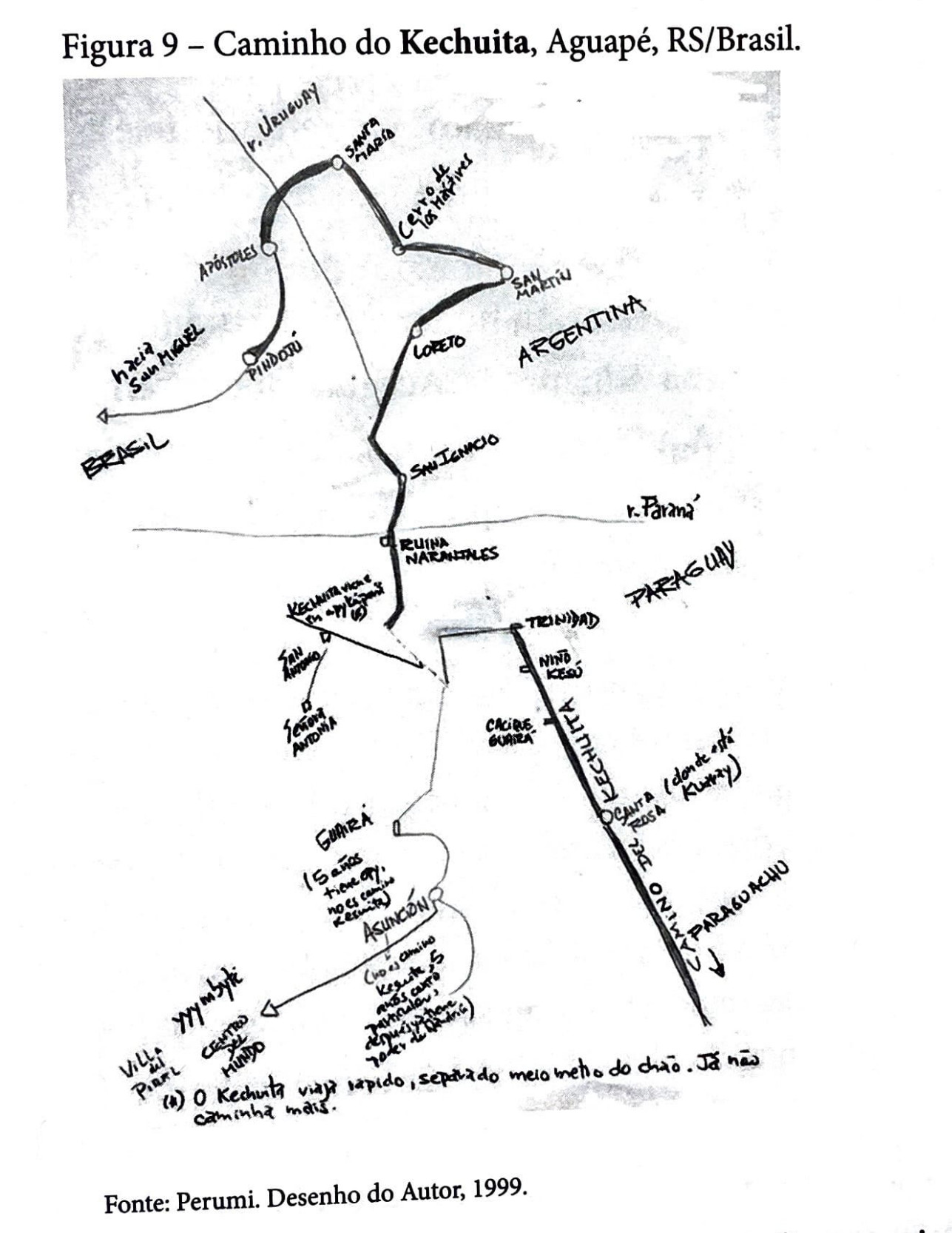
Dispossesions in the Americas

Dispossesions in the Americas

  • Home
  • Explore
  • About
  • Authors
  • Art
  • Bodies
  • Curricula
  • Cultural Heritage
  • Maps
  • Territories
Back to Explore
Map 1999

Caminho do Kechuita, Aguapé, RS/Brasil

  • BASINI, JOSE

Published: 1999

  • Download Image

Peoples

  • GUARANI

Citation

Basini, José. Índios Num País Sem Índios - A Estética Do Desaparecimento: Um Estudo Sobre Imagens Índias E Versões Étnicas. Manaus: Travessia/Fapeam, 2015, p. 253. Physical copy requested from: https://franklin.library.upenn.edu/catalog/FRANKLIN_9977138824303681)

  • Download Image

Reading in Spanish

Map 1999

Caminho do Kechuita, Aguapé, RS/Brasil

  • BASINI, JOSE

Published: 1999

  • Download Image
  • Download Image

Reading in Portuguese

Map 1999

Caminho do Kechuita, Aguapé, RS/Brasil

  • BASINI, JOSE

Published: 1999

  • Download Image

Peoples

  • GUARANI

Citation

Basini, José. Índios Num País Sem Índios - A Estética Do Desaparecimento: Um Estudo Sobre Imagens Índias E Versões Étnicas. Manaus: Travessia/Fapeam, 2015, p. 253. Physical copy requested from: https://franklin.library.upenn.edu/catalog/FRANKLIN_9977138824303681)

  • Download Image

Related Content

PUEBLO OLUTECO

PUEBLO OLUTECO

Map 2020
Carta Del Gran Chaco e Paesi Confinanti

Carta Del Gran Chaco e Paesi Confinanti

Map 1700 - 1767
Detail from the 1770 copy of Francisco Álvarez Barreiro’s 1728 map of northern New Spain illustrating Spanish mapping of Indian domains in southern Texas and along the Gulf Coast, especially through the repetition of labels: “tierra de los Pampopas,” “tierra de los Carrizos,” “tierra de los Cujanes,” etc.

Detail from the 1770 copy of Francisco Álvarez Barreiro’s 1728 map of northern New Spain illustrating Spanish mapping of Indian domains in southern Texas and along the Gulf Coast, especially through the repetition of labels: “tierra de los Pampopas,” “tierra de los Carrizos,” “tierra de los Cujanes,” etc.

Map 1728
Ubicación geográfica del pueblo mixteco

Ubicación geográfica del pueblo mixteco

Map
DEMARCACIÓN DE LÍMITES DEL PUEBLO REAL DE INDIOS (REDUCCIÓN) DE TALINA (1573)

DEMARCACIÓN DE LÍMITES DEL PUEBLO REAL DE INDIOS (REDUCCIÓN) DE TALINA (1573)

Map 1573
Chile's Indigenous Population

Chile's Indigenous Population

Map 2021
Linea de frontera contra los indios

Linea de frontera contra los indios

Map 1779 - 1829
Guyana

Guyana

Map 1800 - 1899

Dispossessions in the Americas

A project by

University of Pennsylvania

Copyright 2024

With support from

Mellon Foundation

Site design & development

Element 84

Art Credits

Basini, José. Índios Num País Sem Índios - A Estética Do Desaparecimento: Um Estudo Sobre Imagens Índias E Versões Étnicas. Manaus: Travessia/Fapeam, 2015, p. 253. Physical copy requested from: https://franklin.library.upenn.edu/catalog/FRANKLIN_9977138824303681)

Site Pages

  • Home
  • Explore
  • About
  • Authors
  • Art
  • Bodies
  • Curricula
  • Cultural Heritage
  • Maps
  • Territories