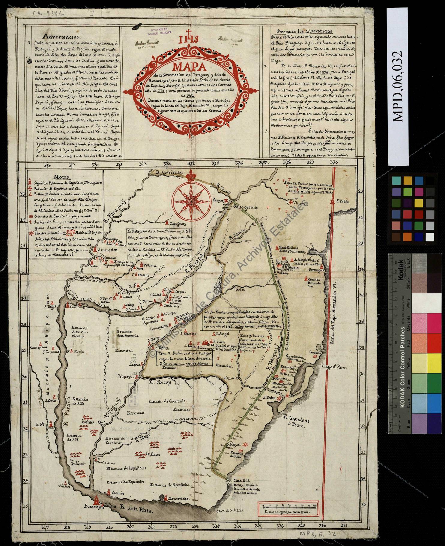
Dispossesions in the Americas

Dispossesions in the Americas

  • Home
  • Explore
  • About
  • Authors
  • Art
  • Bodies
  • Curricula
  • Cultural Heritage
  • Maps
  • Territories
Back to Explore
Map 1752

Mapa de la Governacion del Paraguay y de la de Buenos Ayres con la linea divisoria de las tierras de España y Portugal ajustada entre las dos Coronas año 1750 cuya posesion se pretende tomar este año de 1752

  • CARDIEL, JOSE

Published: 1752

  • Download Image

Peoples

  • GUARANI
  • MOCOBIS
  • ABIPONES

Citation

Cardiel, José. Mapa de la Governacion del Paraguay y de la de Buenos Ayres con la linea divisoria de las tierras de España y Portugal ajustada entre las dos Coronas año 1750 cuya posesion se pretende tomar este año de 1752. Map. Buenos Aires: Archivo General de Simancas, 1752. Accessed June 20, 2022. http://www.mcu.es/ccbae/es/catalogo_imagenes/grupo.do?texto_busqueda&posicion=1&path=1421&presentacion=pagina&config_rotacion=0.

  • Download Image

Reading in Spanish

Map 1752

Mapa de la Governacion del Paraguay y de la de Buenos Ayres con la linea divisoria de las tierras de España y Portugal ajustada entre las dos Coronas año 1750 cuya posesion se pretende tomar este año de 1752

  • CARDIEL, JOSE

Published: 1752

  • Download Image
  • Download Image

Related Content

CARTA GEOGRÁFICA DEL ECUADOR POR DR. TEODORO WOLF;PUBLICADA POR ORDEN DEL SUPREMO GOBIERNO DE LA REPÚBLICA Y TRABAJADA BAJO LAS PRESIDENCIAS DE LOS EE. SEÑORES DR. D.J.M. PLÁCIDO CAAMAÑO Y DR. D. ANTONIO FLORES. 1892 ... INSTITUTO GEOGRAFICO DE H. WAGNER & E. DEBES EN LEIPZIG. (WITH) LA REGION ORIENTAL DEL ECUADOR. (WITH) ARCHIPIÉLAGO DE GALÁPAGOS.

CARTA GEOGRÁFICA DEL ECUADOR POR DR. TEODORO WOLF;PUBLICADA POR ORDEN DEL SUPREMO GOBIERNO DE LA REPÚBLICA Y TRABAJADA BAJO LAS PRESIDENCIAS DE LOS EE. SEÑORES DR. D.J.M. PLÁCIDO CAAMAÑO Y DR. D. ANTONIO FLORES. 1892 ... INSTITUTO GEOGRAFICO DE H. WAGNER & E. DEBES EN LEIPZIG. (WITH) LA REGION ORIENTAL DEL ECUADOR. (WITH) ARCHIPIÉLAGO DE GALÁPAGOS.

Map 1892
Ancient Chinantla

Ancient Chinantla

Map 1962
No Title

No Title

Map 2008
A Description of the Plantations in the Valley of Paneca

A Description of the Plantations in the Valley of Paneca

Map
Distribución Territorial
Actual del Pueblo Yagan. XXII Region de Magallanes y la Antártica Chile

Distribución Territorial Actual del Pueblo Yagan. XXII Region de Magallanes y la Antártica Chile

Map 1993
TLAXCALA

TLAXCALA

Map 2015
Provincia Franciscana de Michoacán

Provincia Franciscana de Michoacán

Map 1500 - 1599
Do Rio Turi ate a entrada do Grao Para

Do Rio Turi ate a entrada do Grao Para

Map 1600 - 1640

Dispossessions in the Americas

A project by

University of Pennsylvania

Copyright 2024

With support from

Mellon Foundation

Site design & development

Element 84

Art Credits

Cardiel, José. Mapa de la Governacion del Paraguay y de la de Buenos Ayres con la linea divisoria de las tierras de España y Portugal ajustada entre las dos Coronas año 1750 cuya posesion se pretende tomar este año de 1752. Map. Buenos Aires: Archivo General de Simancas, 1752. Accessed June 20, 2022. http://www.mcu.es/ccbae/es/catalogo_imagenes/grupo.do?texto_busqueda&posicion=1&path=1421&presentacion=pagina&config_rotacion=0.

Site Pages

  • Home
  • Explore
  • About
  • Authors
  • Art
  • Bodies
  • Curricula
  • Cultural Heritage
  • Maps
  • Territories