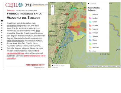
Dispossesions in the Americas

Dispossesions in the Americas

  • Home
  • Explore
  • About
  • Authors
  • Art
  • Bodies
  • Curricula
  • Cultural Heritage
  • Maps
  • Territories
Back to Explore
Map 1680 - 1805

Theories of Indigenous “Habitat”.

  • ERBIG, JEFFREY ALAN JR

Published: 2015

  • Download Image

Peoples

  • CHARRUAS
  • GUENOAS
  • MINUANES
  • BOHANES
  • YAROS

Citation

Erbig, Jeffrey Alan, Jr. "Imperial Lines, Indigenous Lands: Transforming Territorialities of the Río de la Plata, 1680-1805." PhD diss., University of North Carolina at Chapel Hill, 2015. Accessed May 29, 2022. p. 23. https://www.jeffreyerbig.com/uploads/2/0/4/0/20408503/dissertation_erbig.pdf.

  • Download Image

Reading in Spanish

Map 1680 - 1805

Theories of Indigenous “Habitat”.

  • ERBIG, JEFFREY ALAN JR

Published: 2015

  • Download Image
  • Download Image

Related Content

PROVINCIA DO ESPIRITO SANTO

PROVINCIA DO ESPIRITO SANTO

Map 1873
Atlas de Cartas Geográficas de los Países de la América Meridional en que estuvieron situadas las más importantes misiones de los jesuitas;como también de los territorios sobre cuya posesión versaron allí las principales cuestiones entre España y Portugal ;acompañado de varios documentos sobre estas últimas, y precedido de una introducción histórica

Atlas de Cartas Geográficas de los Países de la América Meridional en que estuvieron situadas las más importantes misiones de los jesuitas;como también de los territorios sobre cuya posesión versaron allí las principales cuestiones entre España y Portugal ;acompañado de varios documentos sobre estas últimas, y precedido de una introducción histórica

Map 1750 - 1850
REPRESENTACIÓN EN FORMA DE TRÍPTICO DE LAS TIERRAS DE TEPAL;CUENCA;CORRESPONDE AL EXPEDIENTE PROMOVIDO POR POSESIÓN DE TIERRAS ENTRE LOS INDÍGENAS DE SANTA ANA DE PICHACAY CONTRA MARÍA Y FRANCISCA CAZAR

REPRESENTACIÓN EN FORMA DE TRÍPTICO DE LAS TIERRAS DE TEPAL;CUENCA;CORRESPONDE AL EXPEDIENTE PROMOVIDO POR POSESIÓN DE TIERRAS ENTRE LOS INDÍGENAS DE SANTA ANA DE PICHACAY CONTRA MARÍA Y FRANCISCA CAZAR

Map 1828
Mapa VII.2 Familias lingüísticas en Andes Centro y Sur

Mapa VII.2 Familias lingüísticas en Andes Centro y Sur

Map 2009
Guatimala

Guatimala

Map 1680 - 1685
PAA. Pan American Flight Map. New York and Caribbean.

PAA. Pan American Flight Map. New York and Caribbean.

Map 1508 - 1783
Carte Croquis DU COURS DE L'ORÉNOQUE de Bolivar àu Rio Meta

Carte Croquis DU COURS DE L'ORÉNOQUE de Bolivar àu Rio Meta

Map 1884
Nuremberg Map of Tenochititlan and the Gulf Coast, 1524

Nuremberg Map of Tenochititlan and the Gulf Coast, 1524

Map 1524

Dispossessions in the Americas

A project by

University of Pennsylvania

Copyright 2024

With support from

Mellon Foundation

Site design & development

Element 84

Art Credits

Erbig, Jeffrey Alan, Jr. “Imperial Lines, Indigenous Lands: Transforming Territorialities of the Río de la Plata, 1680-1805.” PhD diss., University of North Carolina at Chapel Hill, 2015. Accessed May 29, 2022. p. 23. https://www.jeffreyerbig.com/uploads/2/0/4/0/20408503/dissertation_erbig.pdf.

Site Pages

  • Home
  • Explore
  • About
  • Authors
  • Art
  • Bodies
  • Curricula
  • Cultural Heritage
  • Maps
  • Territories