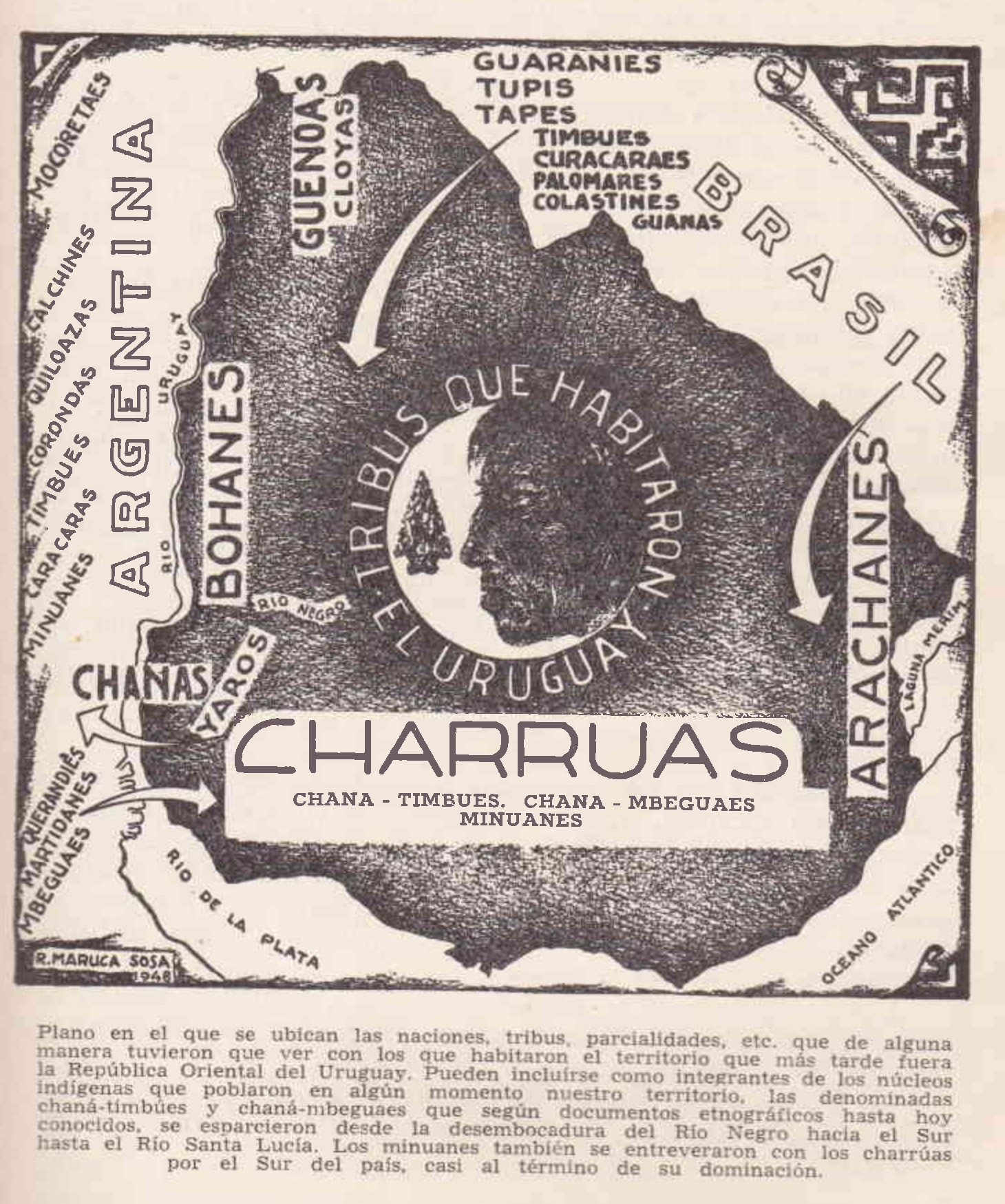
Dispossesions in the Americas

Dispossesions in the Americas

  • Home
  • Explore
  • About
  • Authors
  • Art
  • Bodies
  • Curricula
  • Cultural Heritage
  • Maps
  • Territories
Back to Explore
Map 1500 - 1700

TRIBUS QUE HABITARON URUGUAY

  • SOSA, RODOLFO MARUCA

Published: 1948

  • Download Image

Peoples

  • CHARRUAS
  • MBEGUAES
  • GUENOA-MINUANES
  • ARACHANES
  • CLOYAS
  • BOHANES
  • YAROS
  • CHANAS
  • GUARANI
  • TUPI
  • TAPES
  • CURACARES
  • PALOMARES
  • COLASTINES
  • GUANAS
  • QUERANDIES
  • MARTIDANES
  • CARACARAS
  • TIMBUES
  • CORONDAS
  • GUILOAZAS
  • CALCHINES
  • MOCORETAES

Citation

Sosa, Rodolfo Maruca. La Nación Charrúa. Montevideo: Editorial "Letras", 1957. Accessed May 28, 2022. p. 51. https://pdfcoffee.com/la-nacion-charrua-rodolfo-maruca-sosa-1957-uruguay-pdf-pdf-free.html.

  • Download Image

Reading in Spanish

Map 1500 - 1700

TRIBUS QUE HABITARON URUGUAY

  • SOSA, RODOLFO MARUCA

Published: 1948

  • Download Image
  • Download Image

Reading in Portuguese

Map 1500 - 1700

TRIBUS QUE HABITARON URUGUAY

  • SOSA, RODOLFO MARUCA

Published: 1948

  • Download Image

Peoples

  • CHARRUAS
  • MBEGUAES
  • GUENOA-MINUANES
  • ARACHANES
  • CLOYAS
  • BOHANES
  • YAROS
  • CHANAS
  • GUARANI
  • TUPI
  • TAPES
  • CURACARES
  • PALOMARES
  • COLASTINES
  • GUANAS
  • QUERANDIES
  • MARTIDANES
  • CARACARAS
  • TIMBUES
  • CORONDAS
  • GUILOAZAS
  • CALCHINES
  • MOCORETAES

Citation

Sosa, Rodolfo Maruca. La Nación Charrúa. Montevideo: Editorial "Letras", 1957. Accessed May 28, 2022. p. 51. https://pdfcoffee.com/la-nacion-charrua-rodolfo-maruca-sosa-1957-uruguay-pdf-pdf-free.html.

  • Download Image

Related Content

Plano geográfico de las provincias y terrenos confinantes a la Talamanca con demostración de su montañas, situaciones, etc.

Plano geográfico de las provincias y terrenos confinantes a la Talamanca con demostración de su montañas, situaciones, etc.

Map 1781
Carta plana de la provincia de La Hacha situada entre las de Santa Marta y Maracaybo

Carta plana de la provincia de La Hacha situada entre las de Santa Marta y Maracaybo

Map 1786
Mosquitia or The Mosquito Shore with The Eastern Part of Yucatán as far as the 20th Degree of North Latitude

Mosquitia or The Mosquito Shore with The Eastern Part of Yucatán as far as the 20th Degree of North Latitude

Map 1787
PROVINCIA DE SAPUCAHY

PROVINCIA DE SAPUCAHY

Map 1873
COLOMBIE;VENEZUELA;ECUADOR

COLOMBIE;VENEZUELA;ECUADOR

Map 1930
PLANO de los rios “NAPO” y “PUTUMAYO” levantado por orden del Señor Prefecto del Departamento Coronel D. PEDRO PORTILLO

PLANO de los rios “NAPO” y “PUTUMAYO” levantado por orden del Señor Prefecto del Departamento Coronel D. PEDRO PORTILLO

Map 1903
Población o'ob (pima) en 2010

Población o'ob (pima) en 2010

Map 2010
South America and West Indies. 1818

South America and West Indies. 1818

Map 1818

Dispossessions in the Americas

A project by

University of Pennsylvania

Copyright 2024

With support from

Mellon Foundation

Site design & development

Element 84

Art Credits

Sosa, Rodolfo Maruca. La Nación Charrúa. Montevideo: Editorial “Letras”, 1957. Accessed May 28, 2022. p. 51. https://pdfcoffee.com/la-nacion-charrua-rodolfo-maruca-sosa-1957-uruguay-pdf-pdf-free.html.

Site Pages

  • Home
  • Explore
  • About
  • Authors
  • Art
  • Bodies
  • Curricula
  • Cultural Heritage
  • Maps
  • Territories