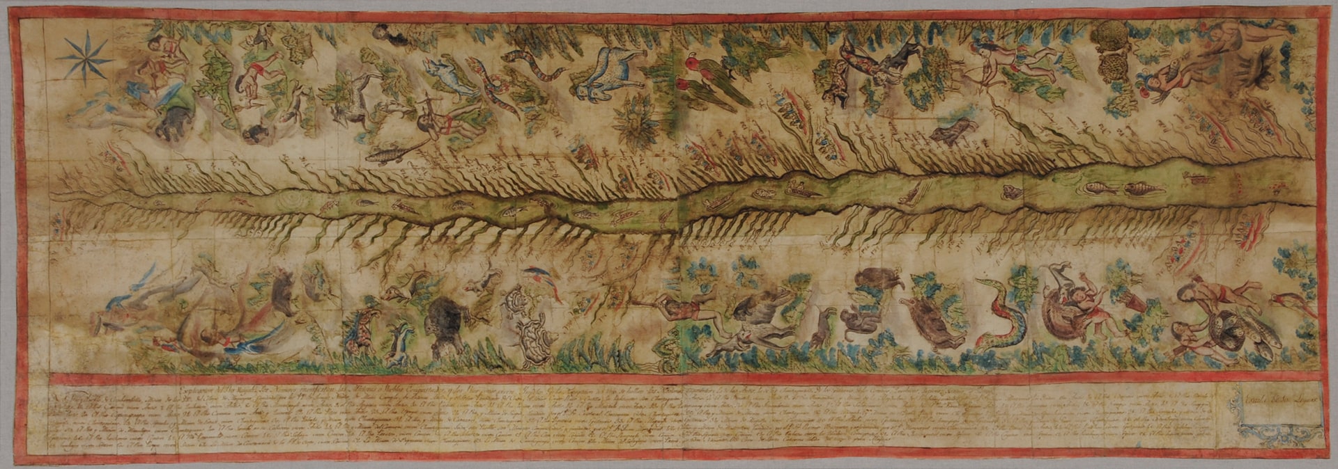
Dispossesions in the Americas

Dispossesions in the Americas

  • Home
  • Explore
  • About
  • Authors
  • Art
  • Bodies
  • Curricula
  • Cultural Heritage
  • Maps
  • Territories
Back to Explore
Map 1808 - 1812

Map of the Ucayali River

  • FRANCISCAN MISSIONARIES;INDIGENOUS ARTISTS

Published: 1812

  • Download Image

Peoples

  • ANTI
  • CASHIBO
  • CHONTAQUIRO
  • CONIBO
  • IPITINERI
  • PANOBO
  • SHETIBO
  • SHIPIBO

Citation

The Hispanic Society (New York), Viceregal Peru, Map of the Ucayali River. https://hispanicsociety.org/exhibition/current-exhibitions-works-on-loan/treasures-on-the-terrace_highlights-from-the-hispanic-society-museum-and-library/ucayali-river/

  • Download Image

Reading in Spanish

Map 1808 - 1812

Map of the Ucayali River

  • FRANCISCAN MISSIONARIES;INDIGENOUS ARTISTS

Published: 1812

  • Download Image
  • Download Image

Reading in Portuguese

Map 1808 - 1812

Map of the Ucayali River

  • FRANCISCAN MISSIONARIES;INDIGENOUS ARTISTS

Published: 1812

  • Download Image

Peoples

  • ANTI
  • CASHIBO
  • CHONTAQUIRO
  • CONIBO
  • IPITINERI
  • PANOBO
  • SHETIBO
  • SHIPIBO

Citation

The Hispanic Society (New York), Viceregal Peru, Map of the Ucayali River. https://hispanicsociety.org/exhibition/current-exhibitions-works-on-loan/treasures-on-the-terrace_highlights-from-the-hispanic-society-museum-and-library/ucayali-river/

  • Download Image

Related Content

Carte réduite des Côtes de la Guyane comprenant les Bouches de la Rivière des Amazones jusqu'à l'Ile de la Trinité

Carte réduite des Côtes de la Guyane comprenant les Bouches de la Rivière des Amazones jusqu'à l'Ile de la Trinité

Map 1817
"Territorio Indígena Cabécar Talamanca"

"Territorio Indígena Cabécar Talamanca"

Map 2010
PROVINCIA DO GRAO PARÁ

PROVINCIA DO GRAO PARÁ

Map 1800 - 1850
4. Ubicación de las comunidades indígenas y composición étnica de la región del Vaupés.

4. Ubicación de las comunidades indígenas y composición étnica de la región del Vaupés.

Map 2013
Carte de la Guyane française

Carte de la Guyane française

Map 1926
"Territorio Indígena Osa (Ngöbes)"

"Territorio Indígena Osa (Ngöbes)"

Map 2010
No nos culpes por lo que pasó [Do not blame us fow what happened]

No nos culpes por lo que pasó [Do not blame us fow what happened]

Artwork
Chili

Chili

Map 1625

Dispossessions in the Americas

A project by

University of Pennsylvania

Copyright 2024

With support from

Mellon Foundation

Site design & development

Element 84

Art Credits

The Hispanic Society (New York), Viceregal Peru, Map of the Ucayali River. https://hispanicsociety.org/exhibition/current-exhibitions-works-on-loan/treasures-on-the-terrace_highlights-from-the-hispanic-society-museum-and-library/ucayali-river/

Site Pages

  • Home
  • Explore
  • About
  • Authors
  • Art
  • Bodies
  • Curricula
  • Cultural Heritage
  • Maps
  • Territories