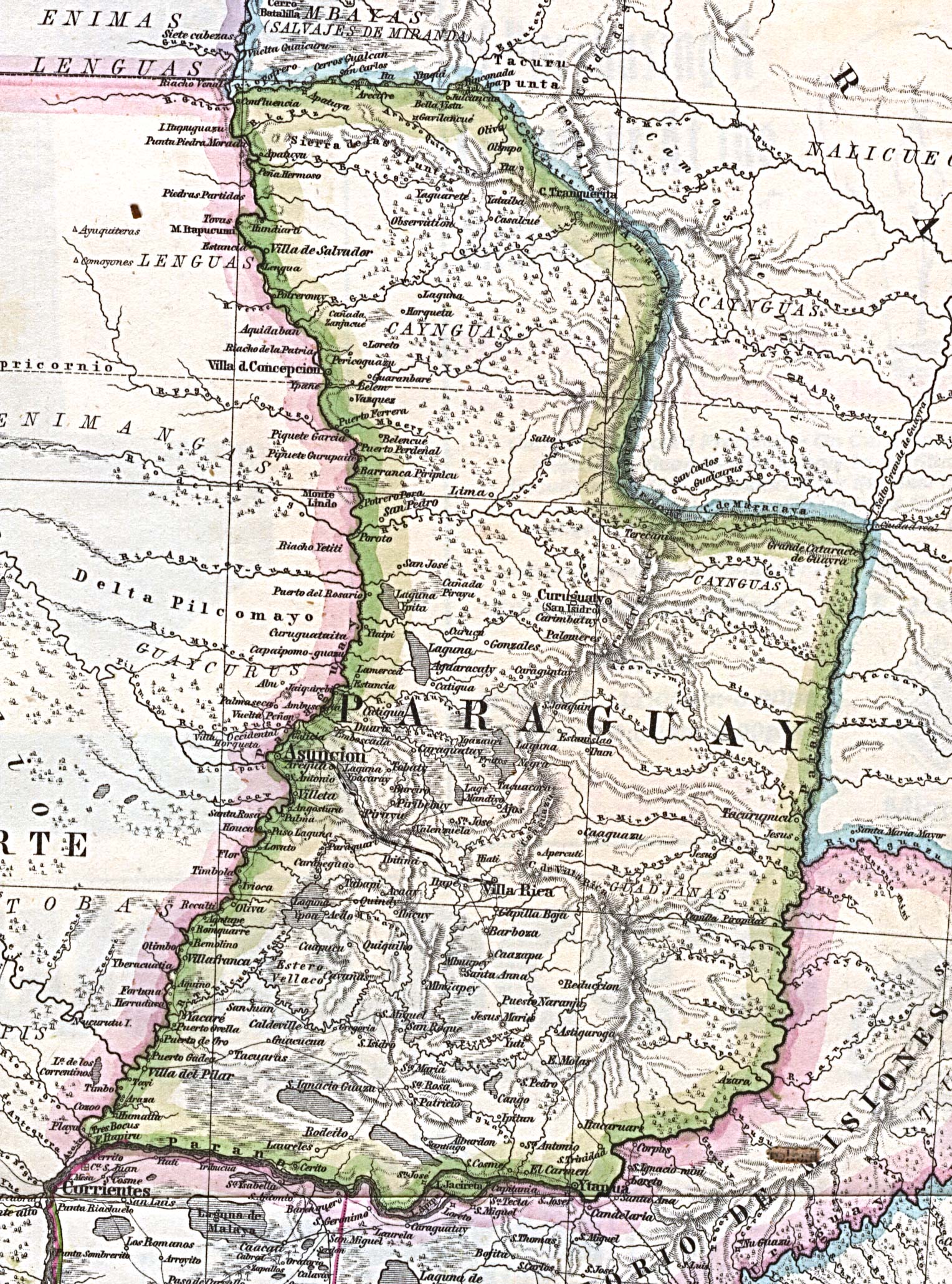
Dispossesions in the Americas

Dispossesions in the Americas

  • Home
  • Explore
  • About
  • Authors
  • Art
  • Bodies
  • Curricula
  • Cultural Heritage
  • Maps
  • Territories
Back to Explore
Map 1875

Mapa Original de la Republica Argentina y Estados Adyacentes Comprendiendo Las Republicas Chile, Paraguay y Uruguay

  • PETERMANN, A.

Published: 1875

  • Download Image

Peoples

  • ENIMAS
  • LENGUAS
  • ENIMANGAS
  • GUAYCURUS
  • TOBAS
  • MBAYAS
  • NALICUEGAS
  • CAYNGUAS
  • GUADJANAS

Citation

"Part of 'Mapa Original de la Republica Argentina y Estados Adyacentes Comprendiendo Las Republicas Chile, Paraguay y Uruguay.'" Map. In Mittheilungen aus Justus Perthes' Geographischer Anstalt uber Wichtige Neue Erforschungen auf dem Gesammtgebiete der Geographie, by A. Petermann. Vol. 9. 1875. Accessed July 5, 2023. https://maps.lib.utexas.edu/maps/historical/paraguay_1875.jpg.

  • Download Image

Reading in Spanish

Map 1875

Mapa Original de la Republica Argentina y Estados Adyacentes Comprendiendo Las Republicas Chile, Paraguay y Uruguay

  • PETERMANN, A.

Published: 1875

  • Download Image
  • Download Image

Related Content

THE AYMARA POLITY OF THE LUPAQA: COMMERCIAL DESTINIES AND VERTICALITY IN THE 16TH CENTURY

THE AYMARA POLITY OF THE LUPAQA: COMMERCIAL DESTINIES AND VERTICALITY IN THE 16TH CENTURY

Map 1500 - 1599
ISLE DE SAINT SÉBASTIEN a la Coste du Brésil

ISLE DE SAINT SÉBASTIEN a la Coste du Brésil

Map 1764
Las Misiones en América del Sur

Las Misiones en América del Sur

Map 1609 - 1832
Carte geographique, statistique et historique de la Guyane.

Carte geographique, statistique et historique de la Guyane.

Map 1800 - 1899
MAPA N. 1 DISTRIBUCIÓN DE LAS AGRUPACIONES Y LENGUAS INDÍGENAS EN 1500

MAPA N. 1 DISTRIBUCIÓN DE LAS AGRUPACIONES Y LENGUAS INDÍGENAS EN 1500

Map 1500
Mapa Corografico De la Provincia de Sta. Marta y parte de las de Cartagena de Yndias, Giron, Pamplona, Maracaybo, Y Rio del Hacha sus confinante

Mapa Corografico De la Provincia de Sta. Marta y parte de las de Cartagena de Yndias, Giron, Pamplona, Maracaybo, Y Rio del Hacha sus confinante

Map 1811
BRAZIL BOLIVIA & PERU

BRAZIL BOLIVIA & PERU

Map 1830
LIENZO DE ZACATEPEC

LIENZO DE ZACATEPEC

Map 1500 - 1599

Dispossessions in the Americas

A project by

University of Pennsylvania

Copyright 2024

With support from

Mellon Foundation

Site design & development

Element 84

Art Credits

“Part of ‘Mapa Original de la Republica Argentina y Estados Adyacentes Comprendiendo Las Republicas Chile, Paraguay y Uruguay.’” Map. In Mittheilungen aus Justus Perthes’ Geographischer Anstalt uber Wichtige Neue Erforschungen auf dem Gesammtgebiete der Geographie, by A. Petermann. Vol. 9. 1875. Accessed July 5, 2023. https://maps.lib.utexas.edu/maps/historical/paraguay_1875.jpg.

Site Pages

  • Home
  • Explore
  • About
  • Authors
  • Art
  • Bodies
  • Curricula
  • Cultural Heritage
  • Maps
  • Territories