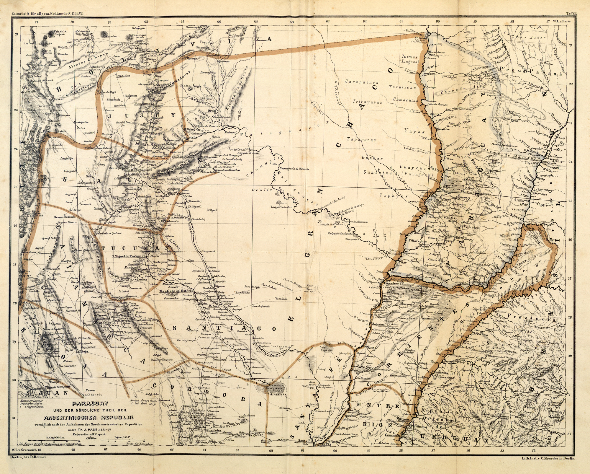
Dispossesions in the Americas

Dispossesions in the Americas

  • Home
  • Explore
  • About
  • Authors
  • Art
  • Bodies
  • Curricula
  • Cultural Heritage
  • Maps
  • Territories
Back to Explore
Map 1853 - 56

PARAGUAY UND DER NÖRDLICHE THEIL DER ARGENTINISCHEN REPUBLIK

  • KEIPERT, H.

Published: 1859

  • Download Image

Peoples

  • MATACO
  • CHUNUPI
  • CARAPAENOS
  • IVIRAYAS
  • TAPARUNOS
  • GUANA
  • GUATUTAS
  • GUAICURU
  • YAYAS
  • CAMACUTAS
  • TARUTICAS
  • LENGUA
  • TOPAYES
  • MBOCOBIS
  • ABIPONES
  • OCOLIS

Citation

Keipert, H. "Paraguay und der nördliche Theil der Argentinischen Republik." Map. In Zeitschrift für Allgemeine Erdkunde, by H. W. Dove, C. G. Ehrenberg, H. Kiepert, C. Ritter, K. Andree, J. E. Wappäus, and K. Neumann, 573. Vol. 7 of Journal of General Geography. Berlin: Dietrich Reimer, 1859. Accessed May 7, 2023. https://www.digizeitschriften.de/id/391365622_1859_0007?tify=%7B%22view%22%3A%22info%22%7D.

  • Download Image

Reading in Spanish

Map 1853 - 56

PARAGUAY UND DER NÖRDLICHE THEIL DER ARGENTINISCHEN REPUBLIK

  • KEIPERT, H.

Published: 1859

  • Download Image
  • Download Image

Reading in Portuguese

Map 1853 - 56

PARAGUAY UND DER NÖRDLICHE THEIL DER ARGENTINISCHEN REPUBLIK

  • KEIPERT, H.

Published: 1859

  • Download Image

Peoples

  • MATACO
  • CHUNUPI
  • CARAPAENOS
  • IVIRAYAS
  • TAPARUNOS
  • GUANA
  • GUATUTAS
  • GUAICURU
  • YAYAS
  • CAMACUTAS
  • TARUTICAS
  • LENGUA
  • TOPAYES
  • MBOCOBIS
  • ABIPONES
  • OCOLIS

Citation

Keipert, H. "Paraguay und der nördliche Theil der Argentinischen Republik." Map. In Zeitschrift für Allgemeine Erdkunde, by H. W. Dove, C. G. Ehrenberg, H. Kiepert, C. Ritter, K. Andree, J. E. Wappäus, and K. Neumann, 573. Vol. 7 of Journal of General Geography. Berlin: Dietrich Reimer, 1859. Accessed May 7, 2023. https://www.digizeitschriften.de/id/391365622_1859_0007?tify=%7B%22view%22%3A%22info%22%7D.

  • Download Image

Related Content

"Territorio Indígena Salitre (Bribri)"

"Territorio Indígena Salitre (Bribri)"

Map 2010
Territorios actuales de los pueblos indígenas en México

Territorios actuales de los pueblos indígenas en México

Map 2008
Hecatombe II

Hecatombe II

Artwork
"Carta Maritima del Reyno de Tierra Firme ú Castilla del Oro : Comprehende el Istmo y Provincia de Panamá, las Provincias de Veragua, Darien y Biruquete"

"Carta Maritima del Reyno de Tierra Firme ú Castilla del Oro : Comprehende el Istmo y Provincia de Panamá, las Provincias de Veragua, Darien y Biruquete"

Map 1729 - 1776
RESGUARDOS Y TERRITORIOS INDIGENAS EN COLOMBIA

RESGUARDOS Y TERRITORIOS INDIGENAS EN COLOMBIA

Map 2015
Coste de Guayane autrement France equinoctiale en la Terre Ferme d'Amérique.

Coste de Guayane autrement France equinoctiale en la Terre Ferme d'Amérique.

Map 1677
INTENDENCIA DE SAN LUIS POTOSÍ

INTENDENCIA DE SAN LUIS POTOSÍ

Map 1800
Quechan settlements, circa 1770-1900

Quechan settlements, circa 1770-1900

Map 1770 - 1900

Dispossessions in the Americas

A project by

University of Pennsylvania

Copyright 2024

With support from

Mellon Foundation

Site design & development

Element 84

Art Credits

Keipert, H. “Paraguay und der nördliche Theil der Argentinischen Republik.” Map. In Zeitschrift für Allgemeine Erdkunde, by H. W. Dove, C. G. Ehrenberg, H. Kiepert, C. Ritter, K. Andree, J. E. Wappäus, and K. Neumann, 573. Vol. 7 of Journal of General Geography. Berlin: Dietrich Reimer, 1859. Accessed May 7, 2023. https://www.digizeitschriften.de/id/391365622_1859_0007?tify=%7B%22view%22%3A%22info%22%7D.

Site Pages

  • Home
  • Explore
  • About
  • Authors
  • Art
  • Bodies
  • Curricula
  • Cultural Heritage
  • Maps
  • Territories