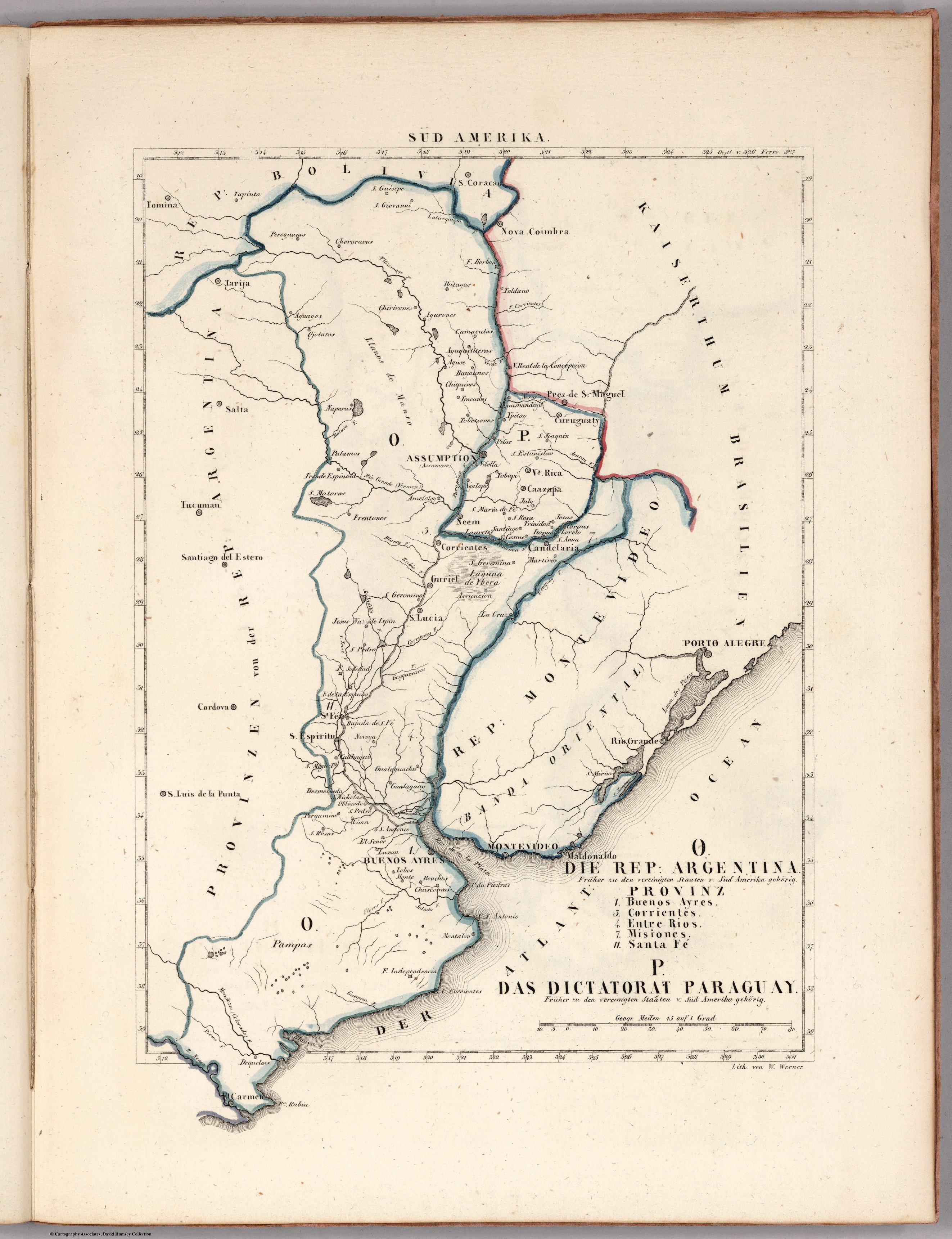
Dispossesions in the Americas

Dispossesions in the Americas

  • Home
  • Explore
  • About
  • Authors
  • Art
  • Bodies
  • Curricula
  • Cultural Heritage
  • Maps
  • Territories
Back to Explore
Map 1830

O. DIE REP: ARGENTINA. P. DAS DICTATORAT PARAGUAY.

  • SCHLIEBEN, WILHELM ERNST AUGUST VON

Published: 1830

  • Download Image

Peoples

  • CHORARACAS
  • IBITAYAS
  • CHIRIGUANO
  • OJOTAES
  • YGARONOS
  • CAMACUTAS
  • AYGUITERAS
  • AGUSE
  • TOBATINES
  • NAPARUS
  • VILELLA

Citation

Schlieben, Wilhelm Ernst August von. O. Die Rep. Argentina. Provinz 1,3,4,7, 11. P. Die Dictatorat Paraguay. Map. Leipzig: George Joachim Goschen, 1830. Accessed April 25, 2023. https://www.davidrumsey.com/luna/servlet/detail/RUMSEY~8~1~269911~90045182:O--Die-Rep--Argentina--Provinz-1,3,?sort=pub_list_no_initialsort%2Cpub_date%2Cpub_list_no%2Cseries_no.

  • Download Image

Reading in Spanish

Map 1830

O. DIE REP: ARGENTINA. P. DAS DICTATORAT PARAGUAY.

  • SCHLIEBEN, WILHELM ERNST AUGUST VON

Published: 1830

  • Download Image
  • Download Image

Reading in Portuguese

Map 1830

O. DIE REP: ARGENTINA. P. DAS DICTATORAT PARAGUAY.

  • SCHLIEBEN, WILHELM ERNST AUGUST VON

Published: 1830

  • Download Image

Peoples

  • CHORARACAS
  • IBITAYAS
  • CHIRIGUANO
  • OJOTAES
  • YGARONOS
  • CAMACUTAS
  • AYGUITERAS
  • AGUSE
  • TOBATINES
  • NAPARUS
  • VILELLA

Citation

Schlieben, Wilhelm Ernst August von. O. Die Rep. Argentina. Provinz 1,3,4,7, 11. P. Die Dictatorat Paraguay. Map. Leipzig: George Joachim Goschen, 1830. Accessed April 25, 2023. https://www.davidrumsey.com/luna/servlet/detail/RUMSEY~8~1~269911~90045182:O--Die-Rep--Argentina--Provinz-1,3,?sort=pub_list_no_initialsort%2Cpub_date%2Cpub_list_no%2Cseries_no.

  • Download Image

Related Content

TERRITORIOS DE LOS PUEBLOS Y NACIONALIDADES;TERRITORIOS DE VIDA Y AREAS PROTEGIDAS EN EL ECUADOR CONTINENTAL

TERRITORIOS DE LOS PUEBLOS Y NACIONALIDADES;TERRITORIOS DE VIDA Y AREAS PROTEGIDAS EN EL ECUADOR CONTINENTAL

Map 2016 - 2018
Ishir (Chamacoco)

Ishir (Chamacoco)

Map 2001
PUEBLO KUMIAI

PUEBLO KUMIAI

Map 2020
Plata, Chili, Paraguay Et Patagonie

Plata, Chili, Paraguay Et Patagonie

Map 1800 - 1880
Lacandon Settlements in Eastern Chiapas

Lacandon Settlements in Eastern Chiapas

Map 1969
A Sequel of the Seat of War in the West Indies containing… Sub-map title: A large & accurate MAP of part of the Isthmus of Panama, taken from a Spanish drought exhibiting the Country adjacent to that City and Puerto Bello, with the Roads and Course of the River CHAGRE, by which the Treasure of the South Sea is conveyed a cross the Isthmus

A Sequel of the Seat of War in the West Indies containing… Sub-map title: A large & accurate MAP of part of the Isthmus of Panama, taken from a Spanish drought exhibiting the Country adjacent to that City and Puerto Bello, with the Roads and Course of the River CHAGRE, by which the Treasure of the South Sea is conveyed a cross the Isthmus

Map 1740
PUEBLOS INDIGENAS

PUEBLOS INDIGENAS

Map 2021
Le Paraguay Tiré des Relations les plus Recentes

Le Paraguay Tiré des Relations les plus Recentes

Map 1668

Dispossessions in the Americas

A project by

University of Pennsylvania

Copyright 2024

With support from

Mellon Foundation

Site design & development

Element 84

Art Credits

Schlieben, Wilhelm Ernst August von. O. Die Rep. Argentina. Provinz 1,3,4,7, 11. P. Die Dictatorat Paraguay. Map. Leipzig: George Joachim Goschen, 1830. Accessed April 25, 2023. https://www.davidrumsey.com/luna/servlet/detail/RUMSEY~8~1~269911~90045182:O--Die-Rep--Argentina--Provinz-1,3,?sort=pub_list_no_initialsort%2Cpub_date%2Cpub_list_no%2Cseries_no.

Site Pages

  • Home
  • Explore
  • About
  • Authors
  • Art
  • Bodies
  • Curricula
  • Cultural Heritage
  • Maps
  • Territories