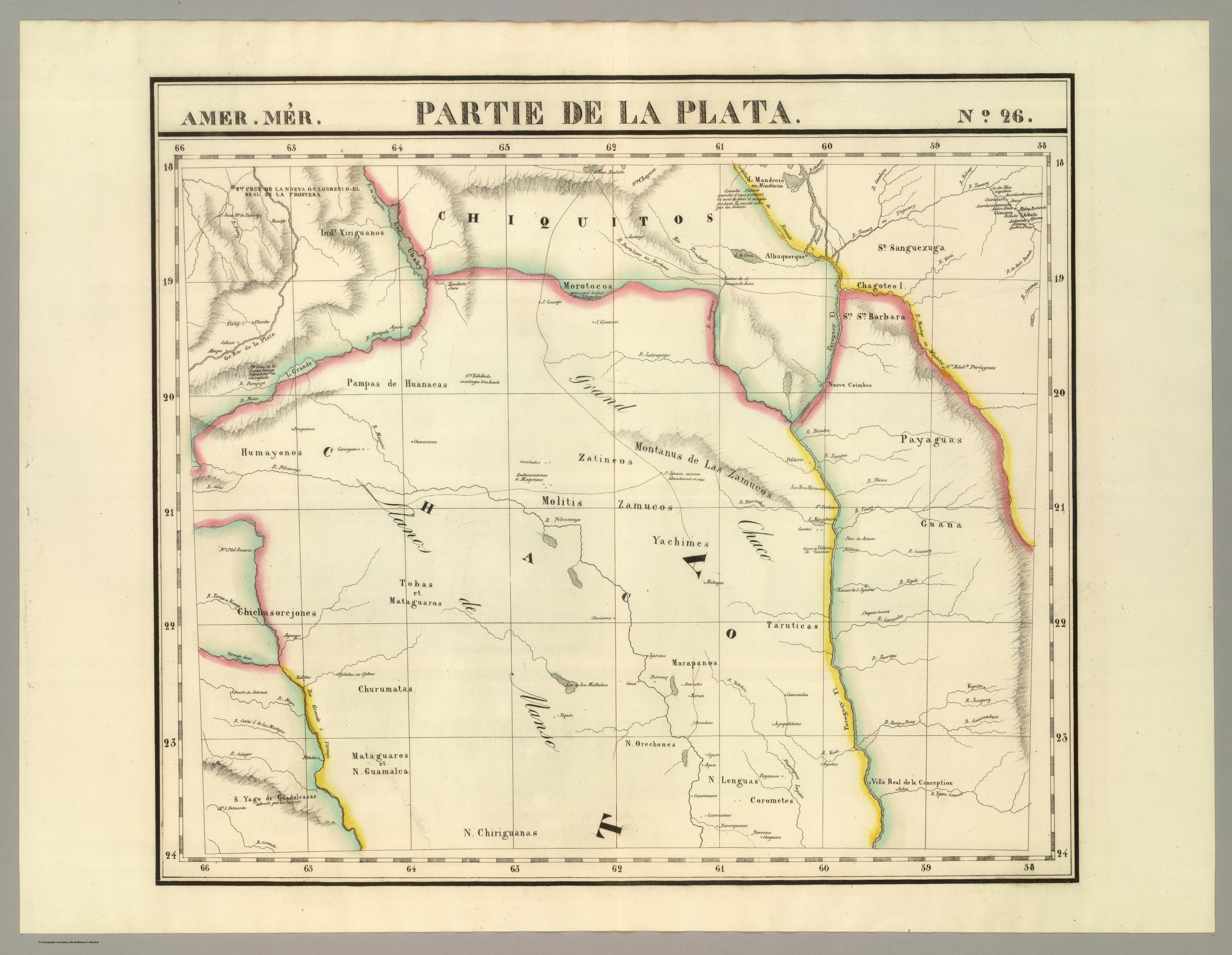
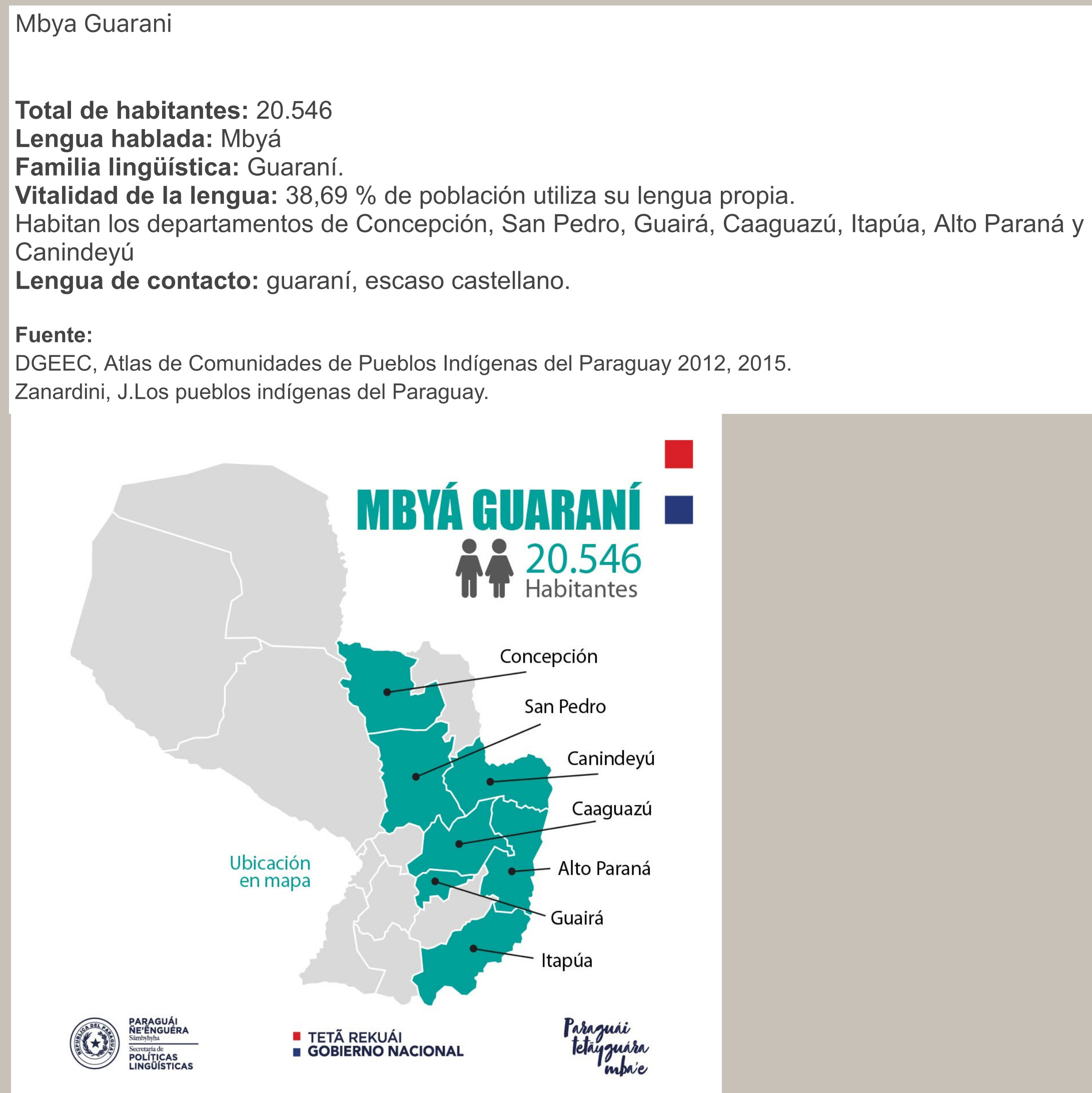
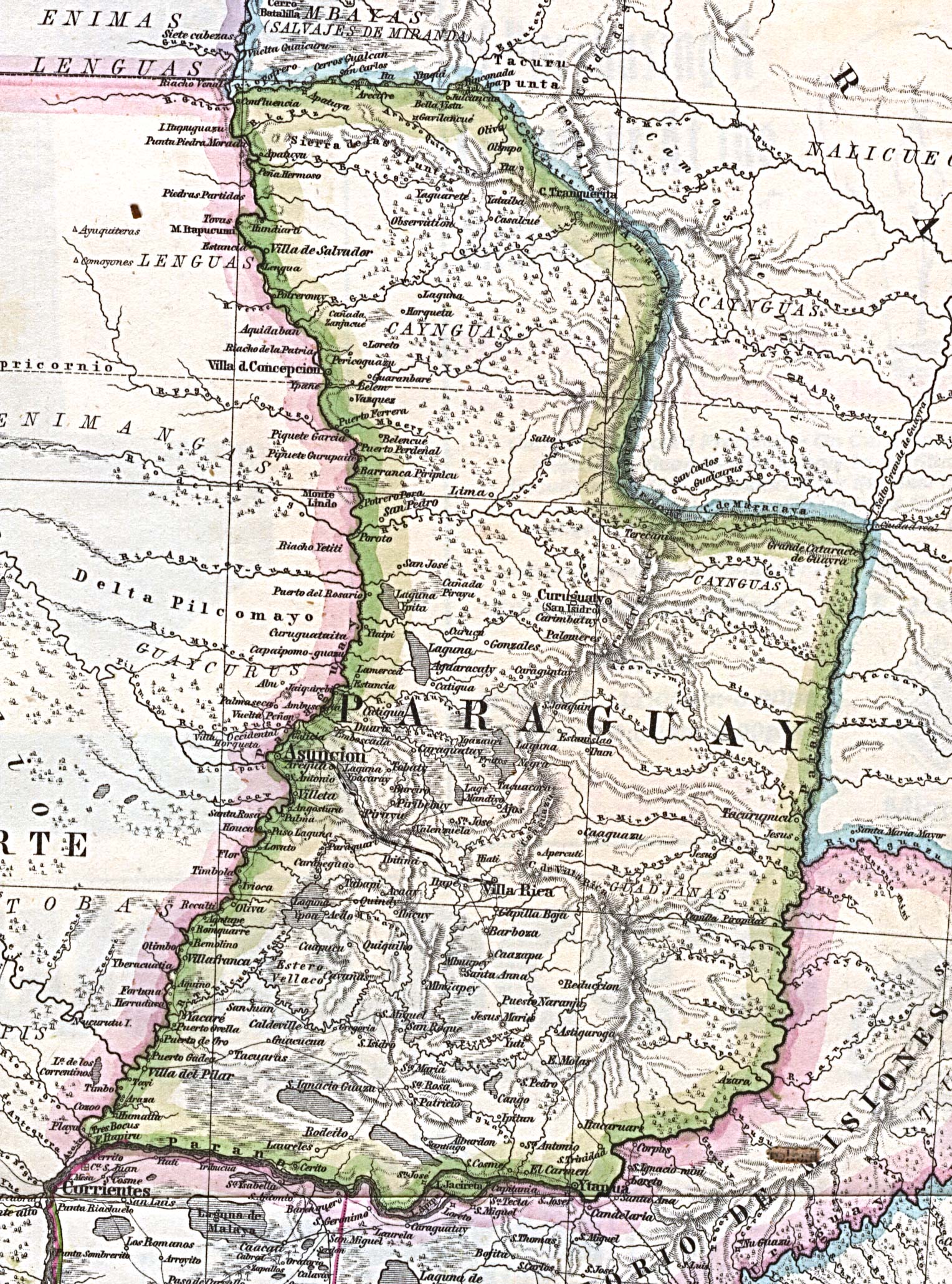
Dispossesions in the Americas

Dispossesions in the Americas

  • Home
  • Explore
  • About
  • Authors
  • Art
  • Bodies
  • Curricula
  • Cultural Heritage
  • Maps
  • Territories
Back to Explore
Map 1825

AMER. MÈR. PARTIE DE LA PLATA. N. 26.

  • VANDERMAELEN, PHILIPPE

Published: 1827

  • Download Image

Peoples

  • AYOREO
  • ZAMUCOS
  • PAYAGUA
  • GUANA
  • YACHIMES
  • TOBA
  • MATACO
  • MARAPANOS
  • TARUTICAS
  • LENGUA
  • OREJONES
  • CHIRIGUANO
  • GUAMALCA
  • MOLITIS
  • ZATINEOS
  • CHURUMATAS
  • CHICHASOREJONES
  • HUMAYONOS

Citation

Vandermaelen, Philippe. Partie, la Plata. Amer. Merid. 26. Map. Bruxelles: Ph. Vandermaelen, 1827. Accessed April 23, 2023. https://www.davidrumsey.com/luna/servlet/detail/RUMSEY~8~1~25265~5500125:Partie,-la-Plata--Amer--Merid--26-?sort=pub_list_no_initialsort%2Cpub_date%2Cpub_list_no%2Cseries_no#.

  • Download Image

Reading in Spanish

Map 1825

AMER. MÈR. PARTIE DE LA PLATA. N. 26.

  • VANDERMAELEN, PHILIPPE

Published: 1827

  • Download Image
  • Download Image

Reading in Portuguese

Map 1825

AMER. MÈR. PARTIE DE LA PLATA. N. 26.

  • VANDERMAELEN, PHILIPPE

Published: 1827

  • Download Image

Peoples

  • AYOREO
  • ZAMUCOS
  • PAYAGUA
  • GUANA
  • YACHIMES
  • TOBA
  • MATACO
  • MARAPANOS
  • TARUTICAS
  • LENGUA
  • OREJONES
  • CHIRIGUANO
  • GUAMALCA
  • MOLITIS
  • ZATINEOS
  • CHURUMATAS
  • CHICHASOREJONES
  • HUMAYONOS

Citation

Vandermaelen, Philippe. Partie, la Plata. Amer. Merid. 26. Map. Bruxelles: Ph. Vandermaelen, 1827. Accessed April 23, 2023. https://www.davidrumsey.com/luna/servlet/detail/RUMSEY~8~1~25265~5500125:Partie,-la-Plata--Amer--Merid--26-?sort=pub_list_no_initialsort%2Cpub_date%2Cpub_list_no%2Cseries_no#.

  • Download Image

Related Content

MBYÁ GUARANÍ

MBYÁ GUARANÍ

Map 2015
MAPA 1. TERRITORIOS DE LOS GRUPOS HUAORANI AL TIEMPO DE CONTACTO

MAPA 1. TERRITORIOS DE LOS GRUPOS HUAORANI AL TIEMPO DE CONTACTO

Map 1958
Theories of Migration (Minuanes).

Theories of Migration (Minuanes).

Map 1680 - 1805
Los amarillos [The Yellow Ones]

Los amarillos [The Yellow Ones]

Artwork
Misiones de los Indios Andaquiez  : sus navegaciones, y Ríos, naciones, y Caminos desde la Ciudad de Neyva hasta el Pueblo de la Ceja, y de este ála Concepción en el Río Putumayo

Misiones de los Indios Andaquiez : sus navegaciones, y Ríos, naciones, y Caminos desde la Ciudad de Neyva hasta el Pueblo de la Ceja, y de este ála Concepción en el Río Putumayo

Map 1792
MAPA DE CUAUHTINCHAN N0. 2

MAPA DE CUAUHTINCHAN N0. 2

Map 1500 - 1599
Mapa Original de la Republica Argentina y Estados Adyacentes Comprendiendo Las Republicas Chile, Paraguay y Uruguay

Mapa Original de la Republica Argentina y Estados Adyacentes Comprendiendo Las Republicas Chile, Paraguay y Uruguay

Map 1875
Preliminary Map;portion of north east [sic] Nicaragua: Brown's Camp to Pis Pis District.

Preliminary Map;portion of north east [sic] Nicaragua: Brown's Camp to Pis Pis District.

Map 1927

Dispossessions in the Americas

A project by

University of Pennsylvania

Copyright 2024

With support from

Mellon Foundation

Site design & development

Element 84

Art Credits

Vandermaelen, Philippe. Partie, la Plata. Amer. Merid. 26. Map. Bruxelles: Ph. Vandermaelen, 1827. Accessed April 23, 2023. https://www.davidrumsey.com/luna/servlet/detail/RUMSEY~8~1~25265~5500125:Partie,-la-Plata--Amer--Merid--26-?sort=pub_list_no_initialsort%2Cpub_date%2Cpub_list_no%2Cseries_no#.

Site Pages

  • Home
  • Explore
  • About
  • Authors
  • Art
  • Bodies
  • Curricula
  • Cultural Heritage
  • Maps
  • Territories