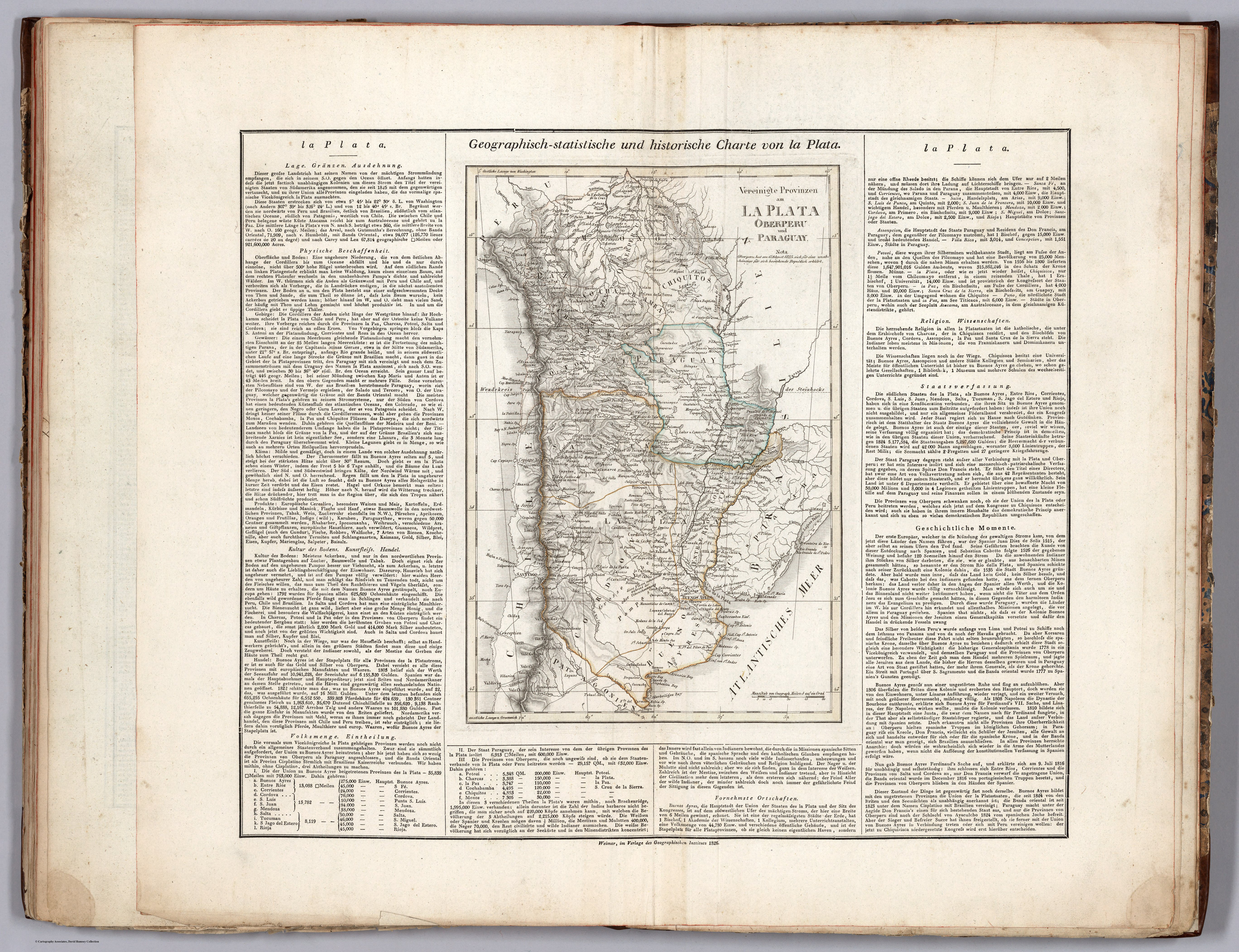
Dispossesions in the Americas

Dispossesions in the Americas

  • Home
  • Explore
  • About
  • Authors
  • Art
  • Bodies
  • Curricula
  • Cultural Heritage
  • Maps
  • Territories
Back to Explore
Map 1826

Vereinigte Provinzen am LA PLATA Oberperu und Paraguay

  • WEILAND, CARL FERDINAND, ET AL.

Published: 1829

  • Download Image

Peoples

  • COLOTAS
  • OJOTAES
  • TEQUETS
  • CHORARACAS
  • CUCUTADES
  • ZAMUCO
  • EMBOCARAOANAS
  • FURUNES
  • JONOCOTES
  • AGUSE
  • PILDORIS
  • IBITAYAS
  • PALALIS
  • TOPAYES
  • GUATUTAS
  • POREREGUANOS
  • GURRUCANES
  • YUCUNAMPAS
  • NAPARUS
  • PALOMOS
  • MUSTAUAS
  • PALCIPAS
  • AMOGEMBAS
  • CALAGAES

Citation

Weiland, Carl Ferdinand, and Georg Hassel. Geographisch-statistische und historische Charte von la Plata. Map. Weimar: Geographischen Instituts, 1826. Accessed April 20, 2023. https://www.davidrumsey.com/luna/servlet/detail/RUMSEY~8~1~297502~90069125:La-Plata-?sort=pub_list_no_initialsort%2Cpub_date%2Cpub_list_no%2Cseries_no#.

  • Download Image

Reading in Spanish

Map 1826

Vereinigte Provinzen am LA PLATA Oberperu und Paraguay

  • WEILAND, CARL FERDINAND, ET AL.

Published: 1829

  • Download Image
  • Download Image

Related Content

Guyanes. Amér. Mérid. no. 7. (Dresse par Ph. Vandermaelen, lithographie par H. Ode. Cinquième partie. - Amer. merid. Bruxelles. 1827)

Guyanes. Amér. Mérid. no. 7. (Dresse par Ph. Vandermaelen, lithographie par H. Ode. Cinquième partie. - Amer. merid. Bruxelles. 1827)

Map 1800 - 1899
La región andina central ecuatoriana

La región andina central ecuatoriana

Map -500 - 1550
Sistema guatemalteco de áreas protegidas (SIGAP) y sitios arqueológicos en 2000.

Sistema guatemalteco de áreas protegidas (SIGAP) y sitios arqueológicos en 2000.

Map 2000
Mapa Del Pais Que Habitan Los Araucanos En Chile, De Poncho Chileno

Mapa Del Pais Que Habitan Los Araucanos En Chile, De Poncho Chileno

Map 1700 - 1800
Mapa de las Comunidades Indígenas en el Paraguay

Mapa de las Comunidades Indígenas en el Paraguay

Map 2004
LOCALIZACION GEOGRAFICA DE LAS COMUNIDADES CIMARRONAS EN COLOMBIA DURANTE LOS SIGLOS XVI Y XVII

LOCALIZACION GEOGRAFICA DE LAS COMUNIDADES CIMARRONAS EN COLOMBIA DURANTE LOS SIGLOS XVI Y XVII

Map 1500 - 1699
Map of Guatemala/to illustrate/Mr. A.P Maudslay's Paper

Map of Guatemala/to illustrate/Mr. A.P Maudslay's Paper

Map 1883
LA PLATA

LA PLATA

Map 1658

Dispossessions in the Americas

A project by

University of Pennsylvania

Copyright 2024

With support from

Mellon Foundation

Site design & development

Element 84

Art Credits

Weiland, Carl Ferdinand, and Georg Hassel. Geographisch-statistische und historische Charte von la Plata. Map. Weimar: Geographischen Instituts, 1826. Accessed April 20, 2023. https://www.davidrumsey.com/luna/servlet/detail/RUMSEY~8~1~297502~90069125:La-Plata-?sort=pub_list_no_initialsort%2Cpub_date%2Cpub_list_no%2Cseries_no#.

Site Pages

  • Home
  • Explore
  • About
  • Authors
  • Art
  • Bodies
  • Curricula
  • Cultural Heritage
  • Maps
  • Territories