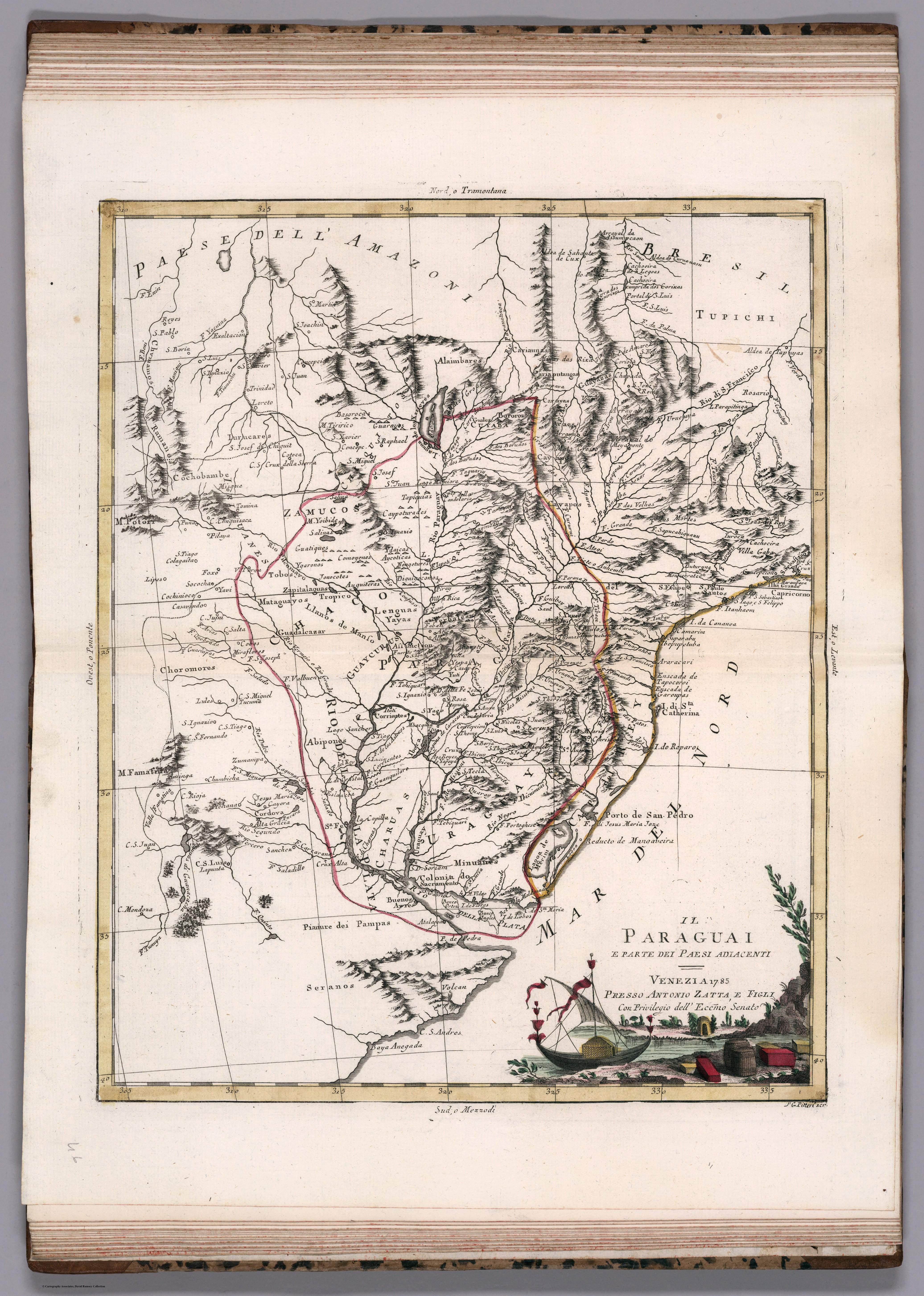
Dispossesions in the Americas

Dispossesions in the Americas

  • Home
  • Explore
  • About
  • Authors
  • Art
  • Bodies
  • Curricula
  • Cultural Heritage
  • Maps
  • Territories
Back to Explore
Map 1785

IL PARAGUAI E PARTE DEI PAESI ADIACENT

  • ZATTA, ANTONIO

Published: 1788

  • Download Image

Peoples

  • TUPICHI
  • CARIAPUTANGAS
  • CARAYAS
  • GUAYAZAS
  • CAYAPOS
  • CARIAUNAS
  • ALAIMBARES
  • CHIQUITO
  • IURUCARES
  • IRIUANES
  • BOROROS
  • ZAMUCO
  • TOBOS
  • GUATIQUES
  • PIALAGA
  • YGARONOS
  • JONOCOTES
  • AYGUITERAS
  • COMOYENES
  • CAYPOTURADES
  • TAPIQUIAS
  • DIGUIYOCONOS
  • CAYAPOS
  • LENGUA
  • MATACO
  • YAYAS
  • GUAICURU
  • CHOROMORES
  • ABIPONES
  • GUENOA-MINUANES
  • CHARRUAS

Citation

Pitteri, Giovanni Marco. Paraguai e parte dei paesi adiacenti. Map. Paris: Libreria de Garnier Hermanos, 1785. Accessed April 20, 2023. https://www.davidrumsey.com/luna/servlet/detail/RUMSEY~8~1~295490~90066633:Il-Paraguai?sort=pub_list_no_initialsort%2Cpub_date%2Cpub_list_no%2Cseries_no#.

  • Download Image

Reading in Spanish

Map 1785

IL PARAGUAI E PARTE DEI PAESI ADIACENT

  • ZATTA, ANTONIO

Published: 1788

  • Download Image
  • Download Image

Related Content

Provincia del Santo Evangelio de Mexico

Provincia del Santo Evangelio de Mexico

Map 1500 - 1599
Fig. 1 Map of the Guianas with schematic locations of the
indigenous groups relevant to our study, based on the linguistic
map of South America (http://www.muturzikin.com/cartesamerique/
7.htm). Carib-speaking groups are indicated in yellow, Arawak-speaking
groups in blue, Tupi-speaking Wayãpi in pink and the Warao-speaking
group in green

Fig. 1 Map of the Guianas with schematic locations of the indigenous groups relevant to our study, based on the linguistic map of South America (http://www.muturzikin.com/cartesamerique/ 7.htm). Carib-speaking groups are indicated in yellow, Arawak-speaking groups in blue, Tupi-speaking Wayãpi in pink and the Warao-speaking group in green

Map 2000 - 2024
Terra Indígena Ribeirão Silveira

Terra Indígena Ribeirão Silveira

Map 2012
COLUMBIA

COLUMBIA

Map 1829
Población yoreme (mayo) en 2010

Población yoreme (mayo) en 2010

Map 2010
BRASILIA

BRASILIA

Map 1600 - 1699
PUEBLO OMAGUA

PUEBLO OMAGUA

Map 2021
Planta do TERRITORIO PARAGUAYO

Planta do TERRITORIO PARAGUAYO

Map 1865 - 1868

Dispossessions in the Americas

A project by

University of Pennsylvania

Copyright 2024

With support from

Mellon Foundation

Site design & development

Element 84

Art Credits

Pitteri, Giovanni Marco. Paraguai e parte dei paesi adiacenti. Map. Paris: Libreria de Garnier Hermanos, 1785. Accessed April 20, 2023. https://www.davidrumsey.com/luna/servlet/detail/RUMSEY~8~1~295490~90066633:Il-Paraguai?sort=pub_list_no_initialsort%2Cpub_date%2Cpub_list_no%2Cseries_no#.

Site Pages

  • Home
  • Explore
  • About
  • Authors
  • Art
  • Bodies
  • Curricula
  • Cultural Heritage
  • Maps
  • Territories