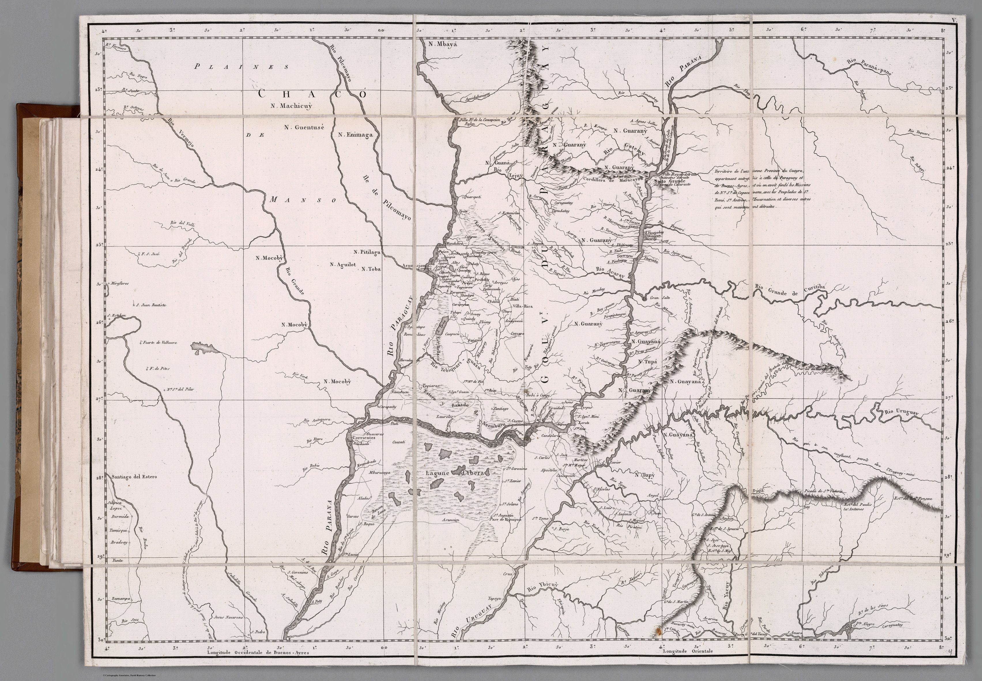
Dispossesions in the Americas

Dispossesions in the Americas

  • Home
  • Explore
  • About
  • Authors
  • Art
  • Bodies
  • Curricula
  • Cultural Heritage
  • Maps
  • Territories
Back to Explore
Map 1781

GOUVERNEMENT DU PARAGUAY ET PARTIE DU CHACO

  • AZARA, DE FELIX

Published: 1809

  • Download Image

Peoples

  • MACHICUIS
  • MBYA
  • GUARANI
  • GUANA
  • ENIMAGA
  • GUENTUSE
  • MBOCOBIS
  • PILAGA
  • AGUILOT
  • TOBA
  • TUPA
  • GUYANA
  • TUPY

Citation

Azara, Felix de. Gouvernement du Paraguay et partie du Chaco. Map. Paris: Dentu, 1809. Accessed April 18, 2023. https://www.davidrumsey.com/luna/servlet/detail/RUMSEY~8~1~321460~90090564:V--Gouvernement-du-Paraguay-et-part?sort=pub_list_no_initialsort%2Cpub_date%2Cpub_list_no%2Cseries_no#.

  • Download Image

Reading in Spanish

Map 1781

GOUVERNEMENT DU PARAGUAY ET PARTIE DU CHACO

  • AZARA, DE FELIX

Published: 1809

  • Download Image
  • Download Image

Reading in Portuguese

Map 1781

GOUVERNEMENT DU PARAGUAY ET PARTIE DU CHACO

  • AZARA, DE FELIX

Published: 1809

  • Download Image

Peoples

  • MACHICUIS
  • MBYA
  • GUARANI
  • GUANA
  • ENIMAGA
  • GUENTUSE
  • MBOCOBIS
  • PILAGA
  • AGUILOT
  • TOBA
  • TUPA
  • GUYANA
  • TUPY

Citation

Azara, Felix de. Gouvernement du Paraguay et partie du Chaco. Map. Paris: Dentu, 1809. Accessed April 18, 2023. https://www.davidrumsey.com/luna/servlet/detail/RUMSEY~8~1~321460~90090564:V--Gouvernement-du-Paraguay-et-part?sort=pub_list_no_initialsort%2Cpub_date%2Cpub_list_no%2Cseries_no#.

  • Download Image

Related Content

Pueblos y territorios indígenas de Honduras (2000)

Pueblos y territorios indígenas de Honduras (2000)

Map 2000
Geographic Map of the Nicaragua with three plans and views.

Geographic Map of the Nicaragua with three plans and views.

Map 1855
MAPA 1. TERRITORIOS DE LOS GRUPOS HUAORANI AL TIEMPO DE CONTACTO

MAPA 1. TERRITORIOS DE LOS GRUPOS HUAORANI AL TIEMPO DE CONTACTO

Map 1958
Población tohono o'otham (pápago) en 2010

Población tohono o'otham (pápago) en 2010

Map 2010
Il Chili con le contrade vicine ed il Paese dei Patagoni

Il Chili con le contrade vicine ed il Paese dei Patagoni

Map 1700 - 1800
Territory of the Jumanos, Mansos, and Sumas

Territory of the Jumanos, Mansos, and Sumas

Map 1997
Guerra con el Indio

Guerra con el Indio

Map 1869 - 1894
The Marañon or Amazon River with the Mission of the Society of Jesus

The Marañon or Amazon River with the Mission of the Society of Jesus

Map 1686 - 1707

Dispossessions in the Americas

A project by

University of Pennsylvania

Copyright 2024

With support from

Mellon Foundation

Site design & development

Element 84

Art Credits

Azara, Felix de. Gouvernement du Paraguay et partie du Chaco. Map. Paris: Dentu, 1809. Accessed April 18, 2023. https://www.davidrumsey.com/luna/servlet/detail/RUMSEY~8~1~321460~90090564:V--Gouvernement-du-Paraguay-et-part?sort=pub_list_no_initialsort%2Cpub_date%2Cpub_list_no%2Cseries_no#.

Site Pages

  • Home
  • Explore
  • About
  • Authors
  • Art
  • Bodies
  • Curricula
  • Cultural Heritage
  • Maps
  • Territories