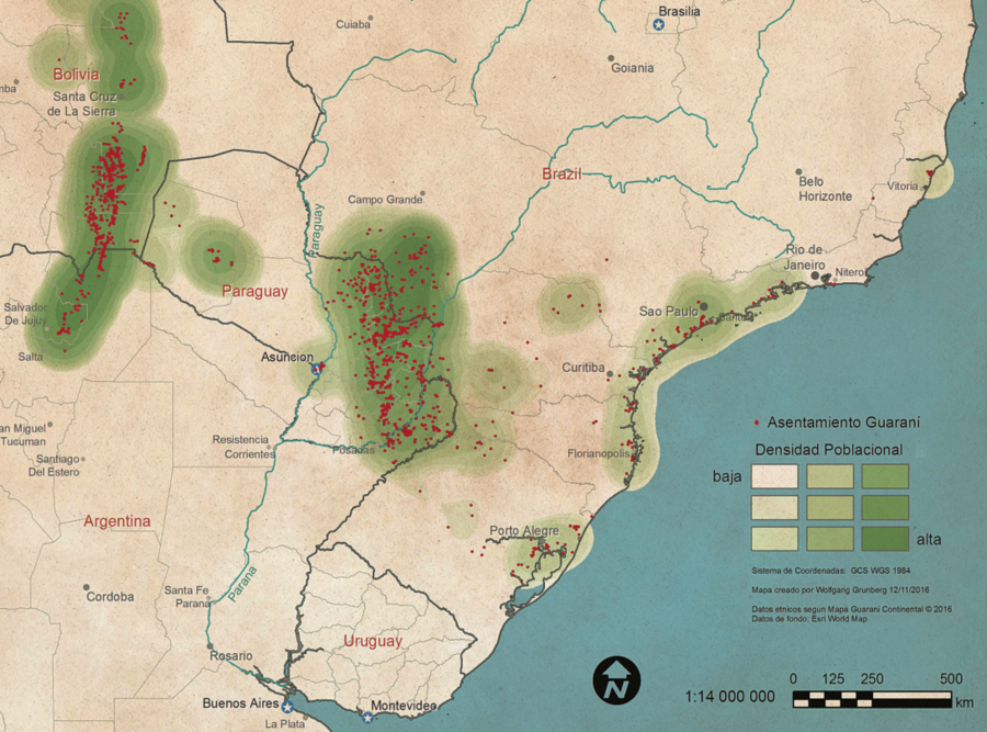
Dispossesions in the Americas

Dispossesions in the Americas

  • Home
  • Explore
  • About
  • Authors
  • Art
  • Bodies
  • Curricula
  • Cultural Heritage
  • Maps
  • Territories
Back to Explore
Map 2016

Mapa Guaraní Continental

  • GRUNBERG, WOLFGANG

Published: 2016

  • Download Image

Peoples

  • MBYA
  • AVA-GUARANI
  • PAI TAVYTERA
  • GUARANI
  • GUARANI OCCIDENTAL
  • TAPIETE
  • GUARANI NANDEVA
  • ACHE
  • CHIRIPA
  • KAIOWA
  • ISOSENO
  • CHIRIGUANOS
  • GWARAYU
  • SIRIONO
  • MBIA
  • GUARASUGWE

Citation

Grunberg, Wolfgang. "Mapa Guaraní Continental." Map. In Guaraní Continental: Pueblos Guaraníes en Argentina, Bolivia, Brasil y Paraguay, by Equipo Mapa Guaraní Continental, 4. Campo Grande, MS, 2016. Accessed April 9, 2023. http://campanhaguarani.org/guaranicontinental/downloads/cuaderno-guarani-espanol-baja.pdf.

  • Download Image

Reading in Spanish

Map 2016

Mapa Guaraní Continental

  • GRUNBERG, WOLFGANG

Published: 2016

  • Download Image
  • Download Image

Reading in Portuguese

Map 2016

Mapa Guaraní Continental

  • GRUNBERG, WOLFGANG

Published: 2016

  • Download Image

Peoples

  • MBYA
  • AVA-GUARANI
  • PAI TAVYTERA
  • GUARANI
  • GUARANI OCCIDENTAL
  • TAPIETE
  • GUARANI NANDEVA
  • ACHE
  • CHIRIPA
  • KAIOWA
  • ISOSENO
  • CHIRIGUANOS
  • GWARAYU
  • SIRIONO
  • MBIA
  • GUARASUGWE

Citation

Grunberg, Wolfgang. "Mapa Guaraní Continental." Map. In Guaraní Continental: Pueblos Guaraníes en Argentina, Bolivia, Brasil y Paraguay, by Equipo Mapa Guaraní Continental, 4. Campo Grande, MS, 2016. Accessed April 9, 2023. http://campanhaguarani.org/guaranicontinental/downloads/cuaderno-guarani-espanol-baja.pdf.

  • Download Image

Related Content

The Southern Maya Lowlands during the Sixteenth and Seventeenth Centuries

The Southern Maya Lowlands during the Sixteenth and Seventeenth Centuries

Map 1500 - 1700
"Mapa del partido de Moniquirá hasta el alto del Mercado."

"Mapa del partido de Moniquirá hasta el alto del Mercado."

Map 1796
PUEBLO POPOLOCA

PUEBLO POPOLOCA

Map 2020
PLAN DE L'ISLE GRANDE, à la côte du Brezil

PLAN DE L'ISLE GRANDE, à la côte du Brezil

Map 1700 - 1750
Mapa geográfico de América meridional.

Mapa geográfico de América meridional.

Map 1755
Terra Indígena Bananal (Peruíbe)

Terra Indígena Bananal (Peruíbe)

Map 2011
MAPA DE CUAUHTINCHAN N0. 2

MAPA DE CUAUHTINCHAN N0. 2

Map 1500 - 1599
Guiana Shewing the Localities of the Principal Indian Nations

Guiana Shewing the Localities of the Principal Indian Nations

Map 1800 - 1899

Dispossessions in the Americas

A project by

University of Pennsylvania

Copyright 2024

With support from

Mellon Foundation

Site design & development

Element 84

Art Credits

Grunberg, Wolfgang. “Mapa Guaraní Continental.” Map. In Guaraní Continental: Pueblos Guaraníes en Argentina, Bolivia, Brasil y Paraguay, by Equipo Mapa Guaraní Continental, 4. Campo Grande, MS, 2016. Accessed April 9, 2023. http://campanhaguarani.org/guaranicontinental/downloads/cuaderno-guarani-espanol-baja.pdf.

Site Pages

  • Home
  • Explore
  • About
  • Authors
  • Art
  • Bodies
  • Curricula
  • Cultural Heritage
  • Maps
  • Territories