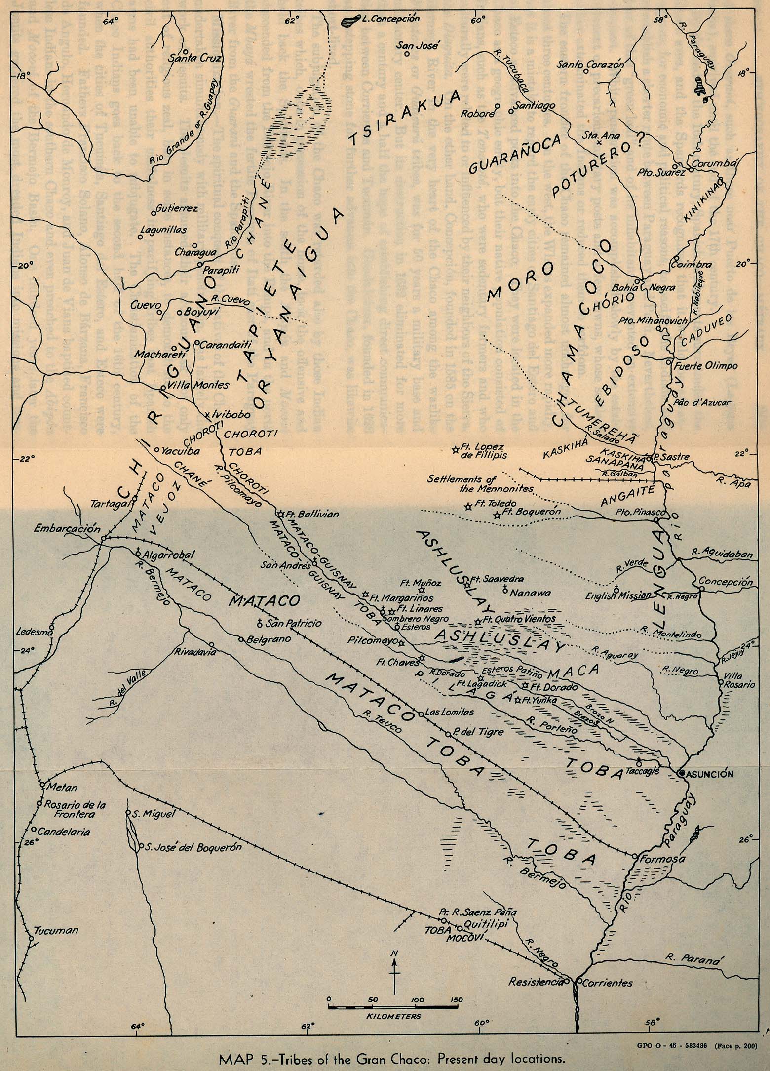
Dispossesions in the Americas

Dispossesions in the Americas

  • Home
  • Explore
  • About
  • Authors
  • Art
  • Bodies
  • Curricula
  • Cultural Heritage
  • Maps
  • Territories
Back to Explore
Map 1946

Tribes of the Gran Chaco: Present day locations

  • SMITHSONIAN INSTITUTION BUREAU OF AMERICAN ETHNOLOGY

Published: 1946

  • Download Image

Peoples

  • CHIRIGUANO
  • ASHLUSLAY
  • GUARANOCA
  • CHANE
  • TAPIETE
  • MATACO
  • TOBA
  • LENGUA
  • ANGAITE
  • CHAMACOCO
  • AYOREO
  • PILAGA
  • GUANA
  • SANAPANA
  • POTURERO
  • HORIO
  • CADUVEO
  • MOCOVI

Citation

Smithsonian Institution Bureau of American Ethnology. "Tribes of the Gran Chaco: Present day locations." Map. University of Texas Libraries. 1946. Accessed April 8, 2023. https://maps.lib.utexas.edu/maps/historical/gran_chaco_present_1946.jpg.

  • Download Image

Reading in Spanish

Map 1946

Tribes of the Gran Chaco: Present day locations

  • SMITHSONIAN INSTITUTION BUREAU OF AMERICAN ETHNOLOGY

Published: 1946

  • Download Image
  • Download Image

Reading in Portuguese

Map 1946

Tribes of the Gran Chaco: Present day locations

  • SMITHSONIAN INSTITUTION BUREAU OF AMERICAN ETHNOLOGY

Published: 1946

  • Download Image

Peoples

  • CHIRIGUANO
  • ASHLUSLAY
  • GUARANOCA
  • CHANE
  • TAPIETE
  • MATACO
  • TOBA
  • LENGUA
  • ANGAITE
  • CHAMACOCO
  • AYOREO
  • PILAGA
  • GUANA
  • SANAPANA
  • POTURERO
  • HORIO
  • CADUVEO
  • MOCOVI

Citation

Smithsonian Institution Bureau of American Ethnology. "Tribes of the Gran Chaco: Present day locations." Map. University of Texas Libraries. 1946. Accessed April 8, 2023. https://maps.lib.utexas.edu/maps/historical/gran_chaco_present_1946.jpg.

  • Download Image

Related Content

Mapa general de la Republica de Guatemala. Publicado por Maximilian v. Sonnenstern por orden del gobierno, 1859. Printed by J. Rau, 33 Broadway, NY. G Kraetzer lith, East New York Long Island, N.Y. "Entered according to act of Congress in the year 1859 by M.v Sonnenster...New York. (insets) Plando de la Ciudad de Guatemala;and 6 releif profiles.

Mapa general de la Republica de Guatemala. Publicado por Maximilian v. Sonnenstern por orden del gobierno, 1859. Printed by J. Rau, 33 Broadway, NY. G Kraetzer lith, East New York Long Island, N.Y. "Entered according to act of Congress in the year 1859 by M.v Sonnenster...New York. (insets) Plando de la Ciudad de Guatemala;and 6 releif profiles.

Map 1800
CHIHUAHUA

CHIHUAHUA

Map 2015
Carte 23: Guyane

Carte 23: Guyane

Map 1900 - 1999
Accuratissima Brasiliae Tabula

Accuratissima Brasiliae Tabula

Map 1600 - 1699
The Misquito: Most important municipios, 2001

The Misquito: Most important municipios, 2001

Map 2001
PUEBLO LACANDON

PUEBLO LACANDON

Map 2020
PROVINCIA DO GRAO PARÁ

PROVINCIA DO GRAO PARÁ

Map 1800 - 1850
LA PLATA

LA PLATA

Map 1658

Dispossessions in the Americas

A project by

University of Pennsylvania

Copyright 2024

With support from

Mellon Foundation

Site design & development

Element 84

Art Credits

Smithsonian Institution Bureau of American Ethnology. “Tribes of the Gran Chaco: Present day locations.” Map. University of Texas Libraries. 1946. Accessed April 8, 2023. https://maps.lib.utexas.edu/maps/historical/gran_chaco_present_1946.jpg.

Site Pages

  • Home
  • Explore
  • About
  • Authors
  • Art
  • Bodies
  • Curricula
  • Cultural Heritage
  • Maps
  • Territories