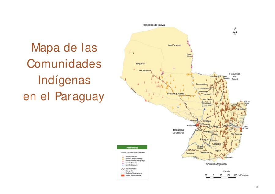
Dispossesions in the Americas

Dispossesions in the Americas

  • Home
  • Explore
  • About
  • Authors
  • Art
  • Bodies
  • Curricula
  • Cultural Heritage
  • Maps
  • Territories
Back to Explore
Map 2004

Mapa de las Comunidades Indígenas en el Paraguay

  • DEPARTAMENTO DE CENSOS DE PARAGUAY

Published: 2002

  • Download Image

Peoples

  • GUARANI
  • MASKOY
  • MATACO MATAGUAYO
  • ZAMUCO
  • GUAICURU

Citation

"Mapa de las Comunidades Indígenas en el Paraguay." Map. In Atlas de las Comunidades Indígenas en el Paraguay, by Nicanor Duarte Frutos, Carlos L. Filippi Sanabria, and Zulma C. Sosa de Servín, 18. Fernando de la Mora: Direção-Geral de Estatísticas da Educação e Ciência, 2004. Accessed April 8, 2023. https://www.ine.gov.py/Publicaciones/Biblioteca/Web%20Atlas%20Indigena/Presentacion.pdf.

  • Download Image

Reading in Spanish

Map 2004

Mapa de las Comunidades Indígenas en el Paraguay

  • DEPARTAMENTO DE CENSOS DE PARAGUAY

Published: 2002

  • Download Image
  • Download Image

Reading in Portuguese

Map 2004

Mapa de las Comunidades Indígenas en el Paraguay

  • DEPARTAMENTO DE CENSOS DE PARAGUAY

Published: 2002

  • Download Image

Peoples

  • GUARANI
  • MASKOY
  • MATACO MATAGUAYO
  • ZAMUCO
  • GUAICURU

Citation

"Mapa de las Comunidades Indígenas en el Paraguay." Map. In Atlas de las Comunidades Indígenas en el Paraguay, by Nicanor Duarte Frutos, Carlos L. Filippi Sanabria, and Zulma C. Sosa de Servín, 18. Fernando de la Mora: Direção-Geral de Estatísticas da Educação e Ciência, 2004. Accessed April 8, 2023. https://www.ine.gov.py/Publicaciones/Biblioteca/Web%20Atlas%20Indigena/Presentacion.pdf.

  • Download Image

Related Content

VENEZUELA: INDIAN LANDS IN CRISIS

VENEZUELA: INDIAN LANDS IN CRISIS

Map 1995
Mapa de los pueblos indigenas Bolivia

Mapa de los pueblos indigenas Bolivia

Map 2010
No Title

No Title

Map 1660
ALGUNOS ESTABLECIMIENTOS ESPANOLES Y PUELOS DE INDIOS "REBELDES" A FINALES DEL SIGLO XVII

ALGUNOS ESTABLECIMIENTOS ESPANOLES Y PUELOS DE INDIOS "REBELDES" A FINALES DEL SIGLO XVII

Map 1600 - 1699
Pueblos de Indios Diaguita Durante la Colonia.

Pueblos de Indios Diaguita Durante la Colonia.

Map 1500 - 1800
Pueblo y tierras de Sopó

Pueblo y tierras de Sopó

Map 1758
Part of the Southwest 1600-1750 Showing Locations of "Unknown Athapaskans"

Part of the Southwest 1600-1750 Showing Locations of "Unknown Athapaskans"

Map 1600 - 1750
FAMILIAS LINGUÍSTICAS Y LENGUAS INDÍGENAS. SEPTIMA REGION: SIERRA NEVADA DE SANTA MARTA

FAMILIAS LINGUÍSTICAS Y LENGUAS INDÍGENAS. SEPTIMA REGION: SIERRA NEVADA DE SANTA MARTA

Map 1989

Dispossessions in the Americas

A project by

University of Pennsylvania

Copyright 2024

With support from

Mellon Foundation

Site design & development

Element 84

Art Credits

“Mapa de las Comunidades Indígenas en el Paraguay.” Map. In Atlas de las Comunidades Indígenas en el Paraguay, by Nicanor Duarte Frutos, Carlos L. Filippi Sanabria, and Zulma C. Sosa de Servín, 18. Fernando de la Mora: Direção-Geral de Estatísticas da Educação e Ciência, 2004. Accessed April 8, 2023. https://www.ine.gov.py/Publicaciones/Biblioteca/Web%20Atlas%20Indigena/Presentacion.pdf.

Site Pages

  • Home
  • Explore
  • About
  • Authors
  • Art
  • Bodies
  • Curricula
  • Cultural Heritage
  • Maps
  • Territories