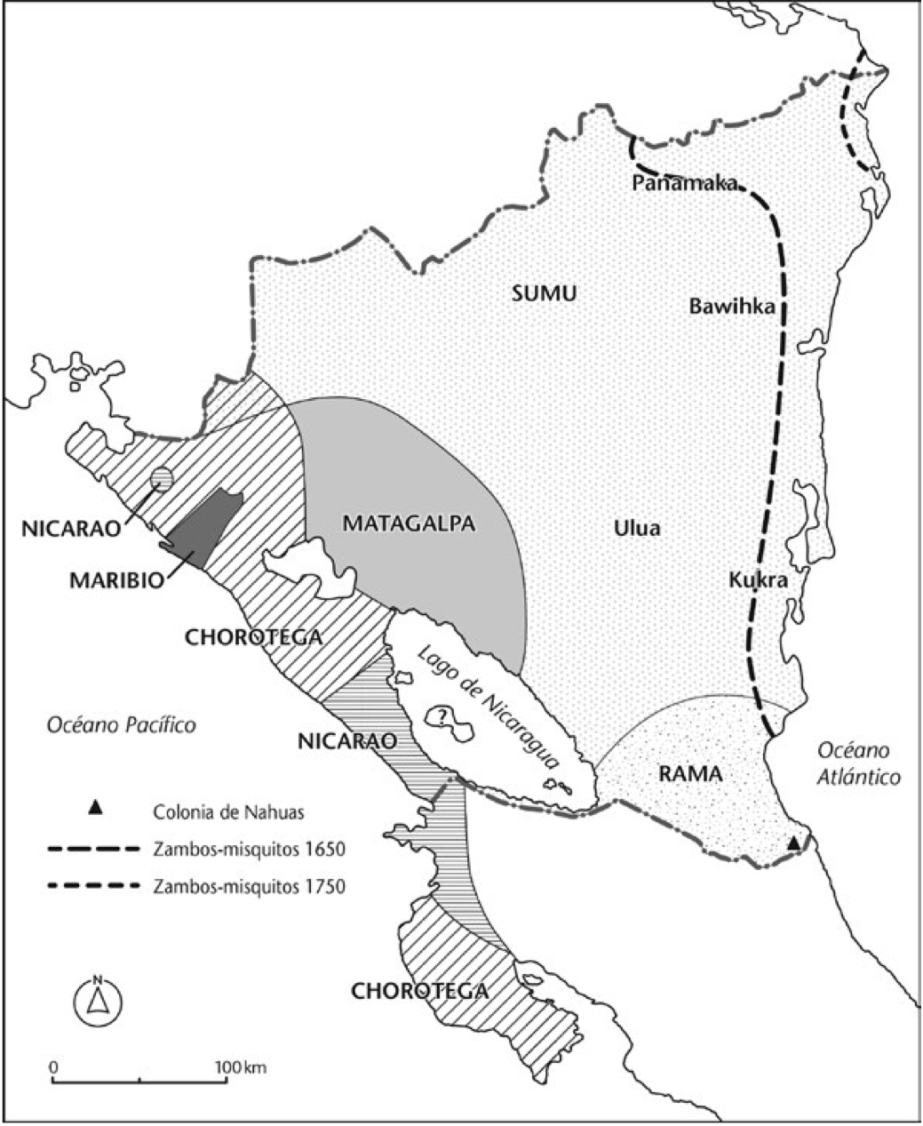
Dispossesions in the Americas

Dispossesions in the Americas

  • Home
  • Explore
  • About
  • Authors
  • Art
  • Bodies
  • Curricula
  • Cultural Heritage
  • Maps
  • Territories
Back to Explore
Map 1650 - 1750

Mapa de las culturas indígenas en vísperas de la conquista española.

  • NEWSON;LINDA

Published: 2021

  • Download Image

Peoples

  • PANAMAKA
  • BAWIHKA
  • SUMU
  • ULUA
  • KUKRA
  • RAMA
  • MATAGALPALA
  • NICARAO
  • MARIBIO
  • CHOROTEGA
  • NAHUA

Citation

Mapa de las culturas indígenas en vísperas de la conquista española. Newson;Linda A. Supervivencia indígena en la Nicaragua colonial. Traducido por Adolfo Bonilla. London;University of London Press 2021. https://library.oapen.org/bitstream/id/4e4ed88b-ba43-4f17-96a3-dd55884c84c5/9781908857873.pdf

  • Download Image

Reading in Spanish

Map 1650 - 1750

Mapa de las culturas indígenas en vísperas de la conquista española.

  • NEWSON;LINDA

Published: 2021

  • Download Image
  • Download Image

Reading in Portuguese

Map 1650 - 1750

Mapa de las culturas indígenas en vísperas de la conquista española.

  • NEWSON;LINDA

Published: 2021

  • Download Image

Peoples

  • PANAMAKA
  • BAWIHKA
  • SUMU
  • ULUA
  • KUKRA
  • RAMA
  • MATAGALPALA
  • NICARAO
  • MARIBIO
  • CHOROTEGA
  • NAHUA

Citation

Mapa de las culturas indígenas en vísperas de la conquista española. Newson;Linda A. Supervivencia indígena en la Nicaragua colonial. Traducido por Adolfo Bonilla. London;University of London Press 2021. https://library.oapen.org/bitstream/id/4e4ed88b-ba43-4f17-96a3-dd55884c84c5/9781908857873.pdf

  • Download Image

Related Content

A Map of part of Yucatan or of that Part of the Eastern Shore Within the Bay of Honduras Alloted to Great Britain for the Cutting of Logwood, in consequence of the Convention Signed with Spain on the 14th July 1786.

A Map of part of Yucatan or of that Part of the Eastern Shore Within the Bay of Honduras Alloted to Great Britain for the Cutting of Logwood, in consequence of the Convention Signed with Spain on the 14th July 1786.

Map 1700
Myth and Religion Series

Myth and Religion Series

Artwork
SCHEMATIC MAP OF DISTRIBUTION OF MAYA-SPEAKING INDIANS (From Morley, 1956, pl.7)

SCHEMATIC MAP OF DISTRIBUTION OF MAYA-SPEAKING INDIANS (From Morley, 1956, pl.7)

Map
O Parque Municipal [The Municipal Park]

O Parque Municipal [The Municipal Park]

Artwork
Paisaje [Landscape]

Paisaje [Landscape]

Artwork
PROVINCIA DO MARANHAO

PROVINCIA DO MARANHAO

Map 1800 - 1850
Medina Bank

Medina Bank

Map 1997
La Rebelión de las Raíces [The Rebellion of the Roots]

La Rebelión de las Raíces [The Rebellion of the Roots]

Artwork

Dispossessions in the Americas

A project by

University of Pennsylvania

Copyright 2024

With support from

Mellon Foundation

Site design & development

Element 84

Art Credits

Mapa de las culturas indígenas en vísperas de la conquista española. Newson;Linda A. Supervivencia indígena en la Nicaragua colonial. Traducido por Adolfo Bonilla. London;University of London Press 2021. https://library.oapen.org/bitstream/id/4e4ed88b-ba43-4f17-96a3-dd55884c84c5/9781908857873.pdf

Site Pages

  • Home
  • Explore
  • About
  • Authors
  • Art
  • Bodies
  • Curricula
  • Cultural Heritage
  • Maps
  • Territories