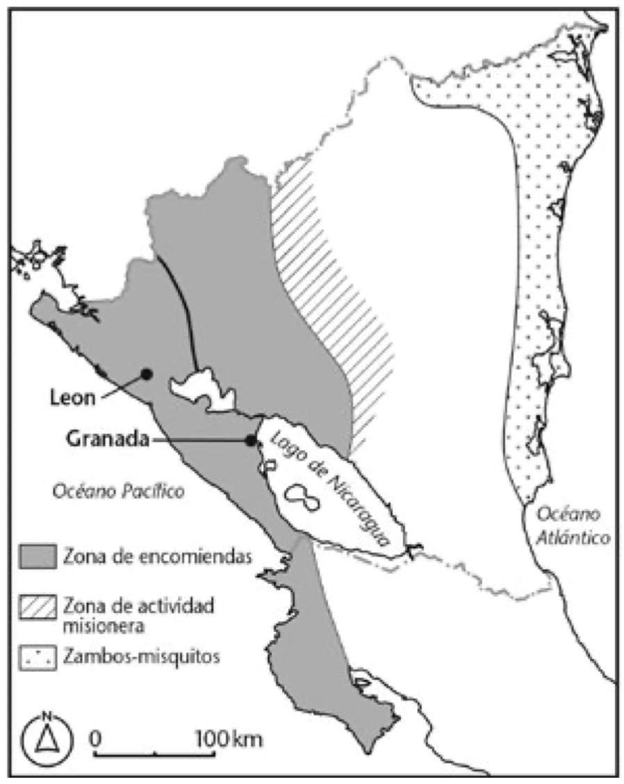
Dispossesions in the Americas

Dispossesions in the Americas

  • Home
  • Explore
  • About
  • Authors
  • Art
  • Bodies
  • Curricula
  • Cultural Heritage
  • Maps
  • Territories
Back to Explore
Map 1720 - 1821

Mapa de Zonas de Influencia Cultural

  • NEWSON;LINDA

Published: 2021

  • Download Image

Peoples

  • ZAMBOS-MISKITOS

Citation

Mapa de Zonas de Influencia Cultural 1720-1821.Newson;Linda A. Supervivencia indígena en la Nicaragua colonial. Traducido por Adolfo Bonilla. London;University of London Press 2021. https://library.oapen.org/bitstream/id/4e4ed88b-ba43-4f17-96a3-dd55884c84c5/9781908857873.pdf

  • Download Image

Reading in Spanish

Map 1720 - 1821

Mapa de Zonas de Influencia Cultural

  • NEWSON;LINDA

Published: 2021

  • Download Image
  • Download Image

Reading in Portuguese

Map 1720 - 1821

Mapa de Zonas de Influencia Cultural

  • NEWSON;LINDA

Published: 2021

  • Download Image

Peoples

  • ZAMBOS-MISKITOS

Citation

Mapa de Zonas de Influencia Cultural 1720-1821.Newson;Linda A. Supervivencia indígena en la Nicaragua colonial. Traducido por Adolfo Bonilla. London;University of London Press 2021. https://library.oapen.org/bitstream/id/4e4ed88b-ba43-4f17-96a3-dd55884c84c5/9781908857873.pdf

  • Download Image

Related Content

PRIMERAS CULTURAS QUITENAS - LA AMAZONIA - GENEALOGÍA - INVASIONES MAYAS

PRIMERAS CULTURAS QUITENAS - LA AMAZONIA - GENEALOGÍA - INVASIONES MAYAS

Map
MAP 8: SELECTED INDIGENOUS IDENTITY GROUPS IN ECUADOR;INCLUDING PUEBLOS

MAP 8: SELECTED INDIGENOUS IDENTITY GROUPS IN ECUADOR;INCLUDING PUEBLOS

Map 2009
Ixil and Q'eqchi' speaking regions of Guatemala.

Ixil and Q'eqchi' speaking regions of Guatemala.

Map 2000
Le Cours de la Riviere des Amazones

Le Cours de la Riviere des Amazones

Map 1680
Mapa de las tierras indígenas - Situación legal

Mapa de las tierras indígenas - Situación legal

Map 2017
Northern Mexico and a Portion of Texas 1600-1750 Showing the approximate Locations of Indian tribes

Northern Mexico and a Portion of Texas 1600-1750 Showing the approximate Locations of Indian tribes

Map 1600 - 1750
PROVINCIE DELLO SPIRITO SANTO E DI PORTO SICURO

PROVINCIE DELLO SPIRITO SANTO E DI PORTO SICURO

Map 1600 - 1699
Guiana Shewing the Localities of the Principal Indian Nations

Guiana Shewing the Localities of the Principal Indian Nations

Map 1800 - 1899

Dispossessions in the Americas

A project by

University of Pennsylvania

Copyright 2024

With support from

Mellon Foundation

Site design & development

Element 84

Art Credits

Mapa de Zonas de Influencia Cultural 1720-1821.Newson;Linda A. Supervivencia indígena en la Nicaragua colonial. Traducido por Adolfo Bonilla. London;University of London Press 2021. https://library.oapen.org/bitstream/id/4e4ed88b-ba43-4f17-96a3-dd55884c84c5/9781908857873.pdf

Site Pages

  • Home
  • Explore
  • About
  • Authors
  • Art
  • Bodies
  • Curricula
  • Cultural Heritage
  • Maps
  • Territories