Dispossesions in the Americas

Dispossesions in the Americas

  • Home
  • Explore
  • About
  • Authors
  • Art
  • Bodies
  • Curricula
  • Cultural Heritage
  • Maps
  • Territories
Back to Explore
Map 1900

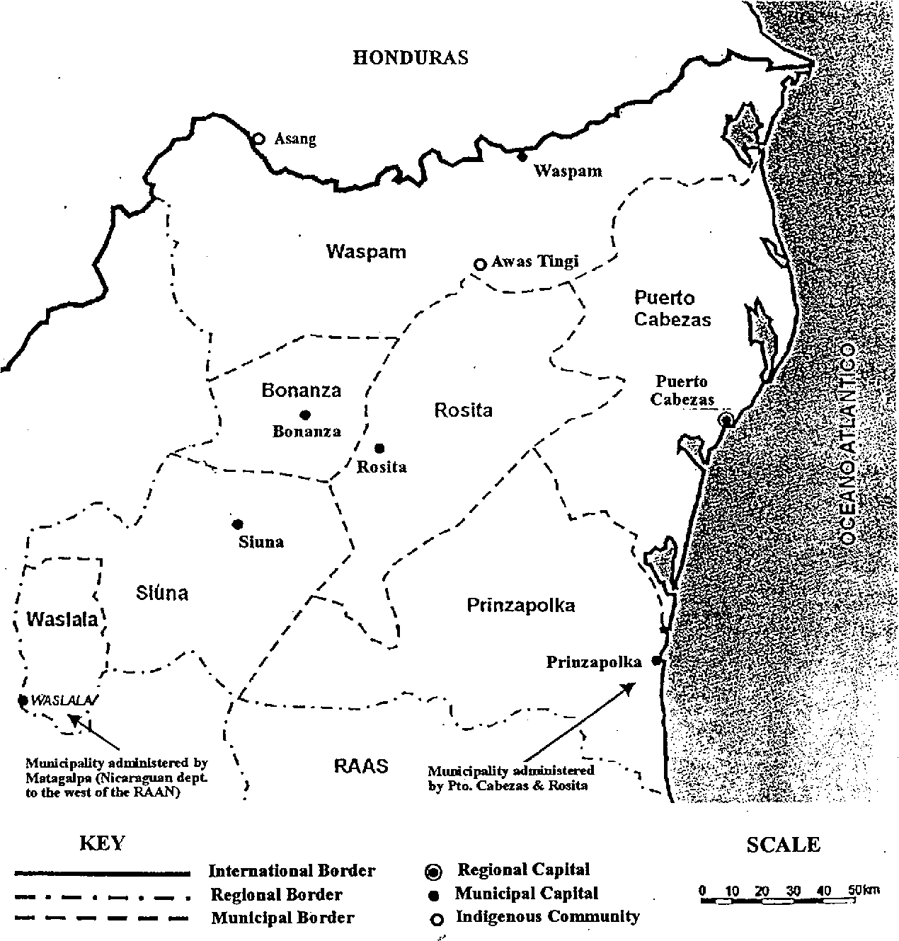
Map of the North Atlantic Autonomous Region (RAAN);Northeastern Nicaragua.

  • CADDY;EMMA

Published: 1998

  • Download Image

Peoples

  • ASANG
  • AWAS
  • TINGI

Citation

Fig 4. Map of the North Atlantic Autonomous Region (RAAN);Northeastern Nicaragua. Caddy;Emma. 1998. "Indigenous perspectives and resource management contexts: the case of northeastern Nicaragua." api. semanticscholar.org/CorpusID:130866240. Accessed July 27 2023. https://www.semanticscholar.org/paper/Indigenous-perspectives-and-resource-management-the-Caddy/fa7fba3ccc0ecdb6562208fda7bbe3cdeb6080ad
  • Download Image

Reading in Spanish

Map 1900

Map of the North Atlantic Autonomous Region (RAAN);Northeastern Nicaragua.

  • CADDY;EMMA

Published: 1998

  • Download Image
  • Download Image

Related Content

Descripción de las Provincias del Chaco, y confinantes segun las relaciones modernas, y noticias adquiridas por diversas entradas de los Misioneros de la Compañía de Jesús que se han hecho en este siglo de 1700.

Descripción de las Provincias del Chaco, y confinantes segun las relaciones modernas, y noticias adquiridas por diversas entradas de los Misioneros de la Compañía de Jesús que se han hecho en este siglo de 1700.

Map 1800 - 1899
"Territorio Indígena Cabécar de Nairi Awari"

"Territorio Indígena Cabécar de Nairi Awari"

Map 2010
Crique Jute

Crique Jute

Map 1997
PARTIE DE LA COLOMBIE

PARTIE DE LA COLOMBIE

Map 1827
Guyanes. Amér. Mérid. no. 7. (Dresse par Ph. Vandermaelen, lithographie par H. Ode. Cinquième partie. - Amer. merid. Bruxelles. 1827)

Guyanes. Amér. Mérid. no. 7. (Dresse par Ph. Vandermaelen, lithographie par H. Ode. Cinquième partie. - Amer. merid. Bruxelles. 1827)

Map 1800 - 1899
Carte d'une partie de l'isthme du Darien (Etats-Unis de Colombie) avec le tracé du Canal Interocéanique / par Lucien de Puydt, Ingénieur, Explorateur de l'isthme du Darien

Carte d'une partie de l'isthme du Darien (Etats-Unis de Colombie) avec le tracé du Canal Interocéanique / par Lucien de Puydt, Ingénieur, Explorateur de l'isthme du Darien

Map 1875
MAPA DE LA NUEVA PROVINCIA POBLADA DE BARBAROS, SITUADA EN LA COSTA DEL SENO MEXICANO, DESDE EL PUERTO DE TAMPICO HASTA LA PROVINCIA DE TEXAS

MAPA DE LA NUEVA PROVINCIA POBLADA DE BARBAROS, SITUADA EN LA COSTA DEL SENO MEXICANO, DESDE EL PUERTO DE TAMPICO HASTA LA PROVINCIA DE TEXAS

Map 1744
What did they actually see?
“Out of control” Pag-127 / “Deviant” Pag-128 / “Possessed” Pag-129 2018

What did they actually see? “Out of control” Pag-127 / “Deviant” Pag-128 / “Possessed” Pag-129 2018

Artwork

Dispossessions in the Americas

A project by

University of Pennsylvania

Copyright 2024

With support from

Mellon Foundation

Site design & development

Element 84

Art Credits

Fig 4. Map of the North Atlantic Autonomous Region (RAAN);Northeastern Nicaragua. Caddy;Emma. 1998. “Indigenous perspectives and resource management contexts: the case of northeastern Nicaragua.” api. semanticscholar.org/CorpusID:130866240. Accessed July 27 2023. https://www.semanticscholar.org/paper/Indigenous-perspectives-and-resource-management-the-Caddy/fa7fba3ccc0ecdb6562208fda7bbe3cdeb6080ad
Site Pages

  • Home
  • Explore
  • About
  • Authors
  • Art
  • Bodies
  • Curricula
  • Cultural Heritage
  • Maps
  • Territories