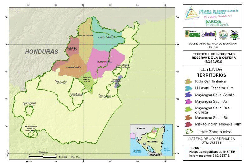
Dispossesions in the Americas

Dispossesions in the Americas

  • Home
  • Explore
  • About
  • Authors
  • Art
  • Bodies
  • Curricula
  • Cultural Heritage
  • Maps
  • Territories
Back to Explore
Map 2000

Indigenous territories and Bosawás in Nicaragua.

  • FREGUIN-GRESH

Published: 2014

  • Download Image

Peoples

  • KIPLA SAIT TASBAIKA
  • LI LAMNI
  • TASBAIKA
  • MAYANGNA SAUNI ARUNKA
  • MARANGA SAUNI AS
  • MAYANGNA SAUNI BAS O SIKILTA
  • MAYANGNA SAUNI BU
  • MISKITU INDIAN TASBAIKA

Citation

Figure 2. Indigenous territories and Bosawás in Nicaragua. Freguin-Gresh;Sandrine. (2014). "Regulations on Access and Property Rights to Natural Resources in Nicaragua and Honduras: Literature review for institutional mapping of the Nicaraguan-Honduras Sentinel Landscape" Working Paper. https://www.researchgate.net/figure/Indigenous-territories-and-Bosawas-in-Nicaragua_fig2_315553210

  • Download Image

Reading in Spanish

Map 2000

Indigenous territories and Bosawás in Nicaragua.

  • FREGUIN-GRESH

Published: 2014

  • Download Image
  • Download Image

Reading in Portuguese

Map 2000

Indigenous territories and Bosawás in Nicaragua.

  • FREGUIN-GRESH

Published: 2014

  • Download Image

Peoples

  • KIPLA SAIT TASBAIKA
  • LI LAMNI
  • TASBAIKA
  • MAYANGNA SAUNI ARUNKA
  • MARANGA SAUNI AS
  • MAYANGNA SAUNI BAS O SIKILTA
  • MAYANGNA SAUNI BU
  • MISKITU INDIAN TASBAIKA

Citation

Figure 2. Indigenous territories and Bosawás in Nicaragua. Freguin-Gresh;Sandrine. (2014). "Regulations on Access and Property Rights to Natural Resources in Nicaragua and Honduras: Literature review for institutional mapping of the Nicaraguan-Honduras Sentinel Landscape" Working Paper. https://www.researchgate.net/figure/Indigenous-territories-and-Bosawas-in-Nicaragua_fig2_315553210

  • Download Image

Related Content

Govierno de Venezuela;1758.

Govierno de Venezuela;1758.

Map 1758
Principales Conventos en el Siglo XVI

Principales Conventos en el Siglo XVI

Map 1500 - 1599
Major Places of Mayo Settlement

Major Places of Mayo Settlement

Map 1969
N. 100. Carte de la Guyane Française

N. 100. Carte de la Guyane Française

Map 1878
Chile's Indigenous Population

Chile's Indigenous Population

Map 2021
Preconquest and Modern Boundaries of Tarascan Speech

Preconquest and Modern Boundaries of Tarascan Speech

Map 1550 - 1999
PUEBLO KUKAMA KUKAMIRIA

PUEBLO KUKAMA KUKAMIRIA

Map 2021
Radicación de Comunidades Mapuche. Titulos de Comisario y Titulos de Merced

Radicación de Comunidades Mapuche. Titulos de Comisario y Titulos de Merced

Map 1884 - 1929

Dispossessions in the Americas

A project by

University of Pennsylvania

Copyright 2024

With support from

Mellon Foundation

Site design & development

Element 84

Art Credits

Figure 2. Indigenous territories and Bosawás in Nicaragua. Freguin-Gresh;Sandrine. (2014). “Regulations on Access and Property Rights to Natural Resources in Nicaragua and Honduras: Literature review for institutional mapping of the Nicaraguan-Honduras Sentinel Landscape” Working Paper. https://www.researchgate.net/figure/Indigenous-territories-and-Bosawas-in-Nicaragua_fig2_315553210

Site Pages

  • Home
  • Explore
  • About
  • Authors
  • Art
  • Bodies
  • Curricula
  • Cultural Heritage
  • Maps
  • Territories