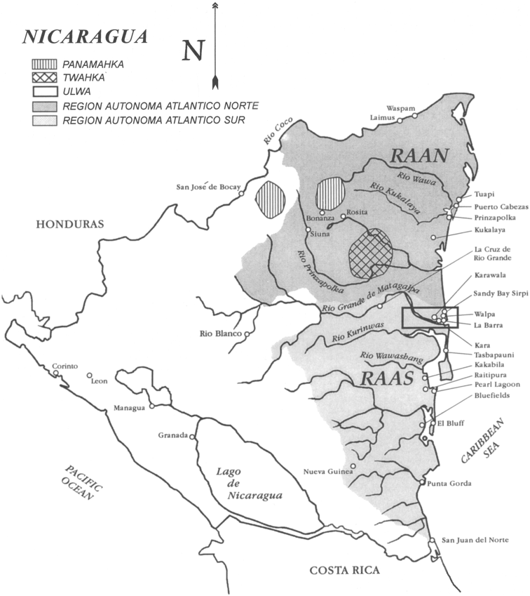
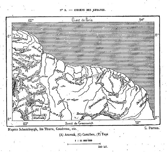
Dispossesions in the Americas

Dispossesions in the Americas

  • Home
  • Explore
  • About
  • Authors
  • Art
  • Bodies
  • Curricula
  • Cultural Heritage
  • Maps
  • Territories
Back to Explore
Map 1990

Map of Nicaragua showing Ulwa settlements in Eastern Nicaragua and field study sites (in rectangle)

  • COE AND ANDERSON

Published: 1999

  • Download Image

Peoples

  • MISKITU
  • ULWA
  • PANAMAHKA
  • TWAHKA

Citation

Figure 1. Map of Nicaragua showing Ulwa settlements in Eastern Nicaragua and field study sites (in rectangle). Coe;Felix and Gregory Anderson. 1999. "Ethnobotany of the Sumu (Ulwa) of Southeastern Nicaragua and comparisons with Miskitu plan lore" Economic Botany. 53(4): pp 363:386. Accessed July 27 2023. https://www.researchgate.net/figure/Map-of-Nicaragua-showing-Ulwa-settlements-in-eastern-Nicaragua-and-field-study-sites-in_fig1_227072089

  • Download Image

Reading in Spanish

Map 1990

Map of Nicaragua showing Ulwa settlements in Eastern Nicaragua and field study sites (in rectangle)

  • COE AND ANDERSON

Published: 1999

  • Download Image
  • Download Image

Reading in Portuguese

Map 1990

Map of Nicaragua showing Ulwa settlements in Eastern Nicaragua and field study sites (in rectangle)

  • COE AND ANDERSON

Published: 1999

  • Download Image

Peoples

  • MISKITU
  • ULWA
  • PANAMAHKA
  • TWAHKA

Citation

Figure 1. Map of Nicaragua showing Ulwa settlements in Eastern Nicaragua and field study sites (in rectangle). Coe;Felix and Gregory Anderson. 1999. "Ethnobotany of the Sumu (Ulwa) of Southeastern Nicaragua and comparisons with Miskitu plan lore" Economic Botany. 53(4): pp 363:386. Accessed July 27 2023. https://www.researchgate.net/figure/Map-of-Nicaragua-showing-Ulwa-settlements-in-eastern-Nicaragua-and-field-study-sites-in_fig1_227072089

  • Download Image

Related Content

FIGURE 26.1. MAP OF COASTAL ECUADOR SHOWING THE PRINCIPAL COASTAL PREHISPANIC CULTURES AND SITES

FIGURE 26.1. MAP OF COASTAL ECUADOR SHOWING THE PRINCIPAL COASTAL PREHISPANIC CULTURES AND SITES

Map 1500
Terra Indígena Itariri (Serra do Itatins)

Terra Indígena Itariri (Serra do Itatins)

Map 2011
Jardín de aclimatación de blancos [White Acclimatization Garden]

Jardín de aclimatación de blancos [White Acclimatization Garden]

Artwork
A Cobra Grande manda para sua filha a noz de Tucunã [The Great Snake sends the Tucunã nut to her daughter]

A Cobra Grande manda para sua filha a noz de Tucunã [The Great Snake sends the Tucunã nut to her daughter]

Artwork
Missiones;quas Provincia Societatis Jesu Paraquarica excolit ad flumina Parana et Urugvay ex natione Guaranica accurate delineatice a quodam ejusdem Missionario Veterano;anno 1744

Missiones;quas Provincia Societatis Jesu Paraquarica excolit ad flumina Parana et Urugvay ex natione Guaranica accurate delineatice a quodam ejusdem Missionario Veterano;anno 1744

Map 1744
Indiens des Guyanes

Indiens des Guyanes

Map 1894
How Rivers Think

How Rivers Think

Artwork
Serie Esclavas de la fiebre de oro [Series Slaves of the Golden Fever]

Serie Esclavas de la fiebre de oro [Series Slaves of the Golden Fever]

Artwork

Dispossessions in the Americas

A project by

University of Pennsylvania

Copyright 2024

With support from

Mellon Foundation

Site design & development

Element 84

Art Credits

Figure 1. Map of Nicaragua showing Ulwa settlements in Eastern Nicaragua and field study sites (in rectangle). Coe;Felix and Gregory Anderson. 1999. “Ethnobotany of the Sumu (Ulwa) of Southeastern Nicaragua and comparisons with Miskitu plan lore” Economic Botany. 53(4): pp 363:386. Accessed July 27 2023. https://www.researchgate.net/figure/Map-of-Nicaragua-showing-Ulwa-settlements-in-eastern-Nicaragua-and-field-study-sites-in_fig1_227072089

Site Pages

  • Home
  • Explore
  • About
  • Authors
  • Art
  • Bodies
  • Curricula
  • Cultural Heritage
  • Maps
  • Territories