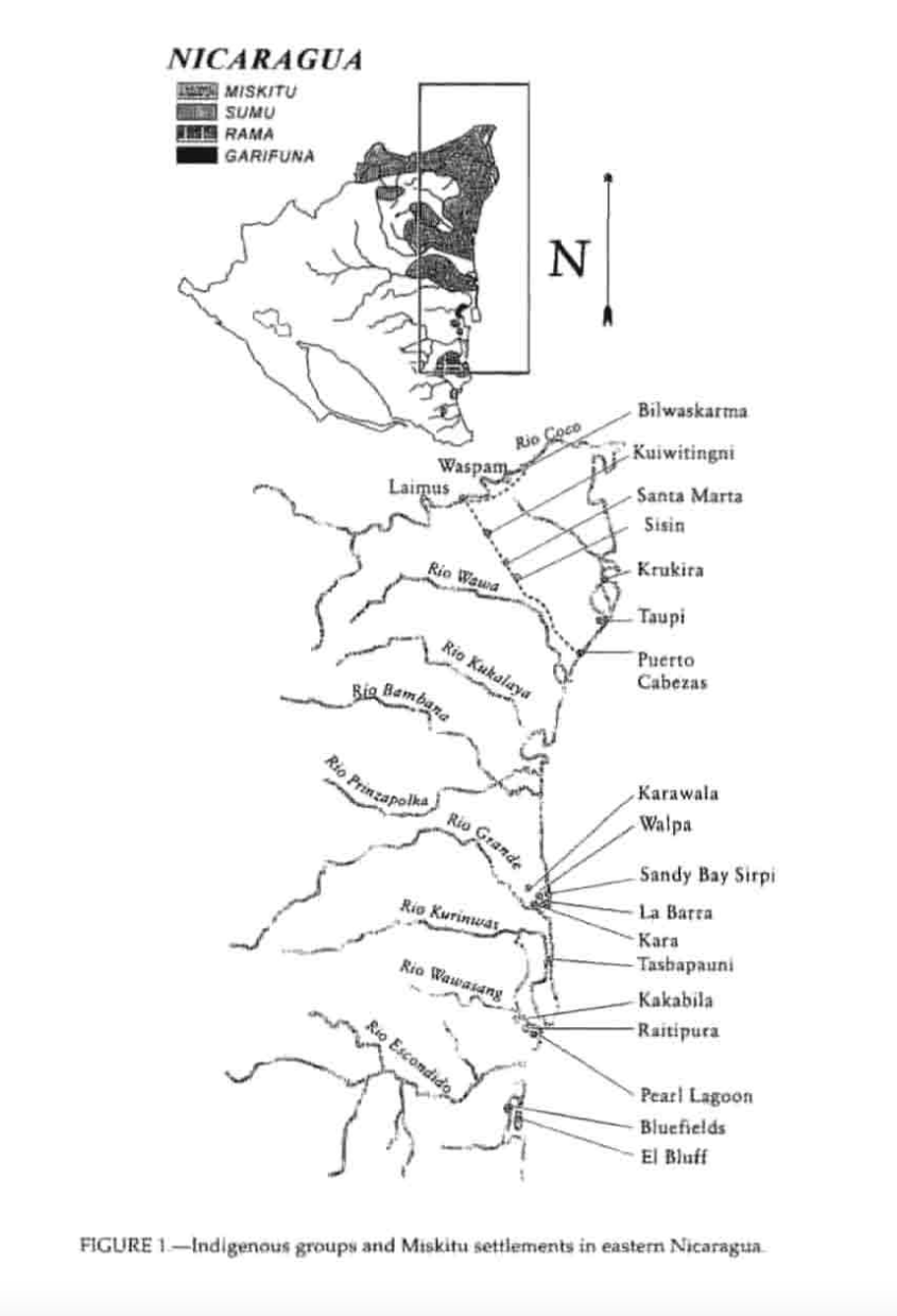
Dispossesions in the Americas

Dispossesions in the Americas

  • Home
  • Explore
  • About
  • Authors
  • Art
  • Bodies
  • Curricula
  • Cultural Heritage
  • Maps
  • Territories
Back to Explore
Map 1990

Indigenous groups and Miskitu settlements in eastern Nicaragua.

  • COE AND ANDERSON

Published: 1997

  • Download Image

Peoples

  • MISKITU
  • SUMU
  • RAMA
  • GARIFUNA

Citation

Figure 1: Indigenous groups and Miskitu settlements in eastern Nicaragua. Coe;Felix and Gregory Anderson.1997."Ethnobotany of the Miskitu in Eastern Nicaragua." Journal of Ethnobotany 17(2):171-214. https://ethnobiology.org/sites/default/files/pdfs/JoE/17-2/CoeAnderson1997.pdf

  • Download Image

Reading in Spanish

Map 1990

Indigenous groups and Miskitu settlements in eastern Nicaragua.

  • COE AND ANDERSON

Published: 1997

  • Download Image
  • Download Image

Related Content

No Title

No Title

Map 1619
SOUTH AMERICA SHEET I. ECUADOR;GRANADA;VENEZUELA;AND PARTS OF BRAZIL AND GUAYANA

SOUTH AMERICA SHEET I. ECUADOR;GRANADA;VENEZUELA;AND PARTS OF BRAZIL AND GUAYANA

Map 1842
CHIAPAS

CHIAPAS

Map 2015
Carte d'une partie de la Guyanne extraite des observations faites en 1762, 1763 et 1764.

Carte d'une partie de la Guyanne extraite des observations faites en 1762, 1763 et 1764.

Map 1762 - 1764
Tawahka homeland, 1916: Showing Río Wampú (Wanpo), Río Patuca (Butuk), Cerro Quigungun (Wangkibila Volc [anol]), and the first cartographical rendering of Krautara (Moravian Archives, Bethlehem, Pennsylvania, Heath 1916)

Tawahka homeland, 1916: Showing Río Wampú (Wanpo), Río Patuca (Butuk), Cerro Quigungun (Wangkibila Volc [anol]), and the first cartographical rendering of Krautara (Moravian Archives, Bethlehem, Pennsylvania, Heath 1916)

Map 1916
Pueblo Guaraní - Comunidad Kaa Puku - Campo Largo

Pueblo Guaraní - Comunidad Kaa Puku - Campo Largo

Map 2020
La Rebelión de las Raíces [The Rebellion of the Roots]

La Rebelión de las Raíces [The Rebellion of the Roots]

Artwork
Plano geográfico de las provincias y terrenos confinantes a la Talamanca con demostración de su montañas, situaciones, etc.

Plano geográfico de las provincias y terrenos confinantes a la Talamanca con demostración de su montañas, situaciones, etc.

Map 1781

Dispossessions in the Americas

A project by

University of Pennsylvania

Copyright 2024

With support from

Mellon Foundation

Site design & development

Element 84

Art Credits

Figure 1: Indigenous groups and Miskitu settlements in eastern Nicaragua. Coe;Felix and Gregory Anderson.1997.“Ethnobotany of the Miskitu in Eastern Nicaragua.” Journal of Ethnobotany 17(2):171-214. https://ethnobiology.org/sites/default/files/pdfs/JoE/17-2/CoeAnderson1997.pdf

Site Pages

  • Home
  • Explore
  • About
  • Authors
  • Art
  • Bodies
  • Curricula
  • Cultural Heritage
  • Maps
  • Territories