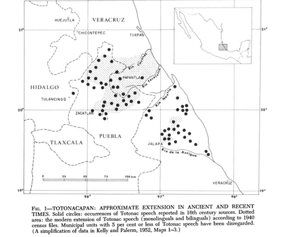
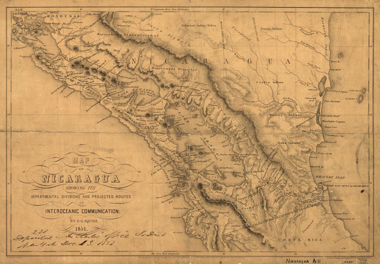
Dispossesions in the Americas

Dispossesions in the Americas

  • Home
  • Explore
  • About
  • Authors
  • Art
  • Bodies
  • Curricula
  • Cultural Heritage
  • Maps
  • Territories
Back to Explore
Map 1851

Map of Nicaragua showing departmental divisionsand projected routes of interoceanic communication.

  • SARONY & MAJOR

Published: 1851

  • Download Image

Peoples

  • TOACAS INDIANS
  • COOKRA INDIANS
  • WOOLWA INDIANS
  • RAMA INDIANS

Citation

Map of Nicaragua showing departmental divisionsand projected routes of interoceanic communication. Sarony & Major. 1851. New York. Library of Congress.G4850 1851 .S2 TIL. http://hdl.loc.gov/loc.gmd/g4850.ct000428AccessedJuly252023

  • Download Image

Reading in Spanish

Map 1851

Map of Nicaragua showing departmental divisionsand projected routes of interoceanic communication.

  • SARONY & MAJOR

Published: 1851

  • Download Image
  • Download Image

Reading in Portuguese

Map 1851

Map of Nicaragua showing departmental divisionsand projected routes of interoceanic communication.

  • SARONY & MAJOR

Published: 1851

  • Download Image

Peoples

  • TOACAS INDIANS
  • COOKRA INDIANS
  • WOOLWA INDIANS
  • RAMA INDIANS

Citation

Map of Nicaragua showing departmental divisionsand projected routes of interoceanic communication. Sarony & Major. 1851. New York. Library of Congress.G4850 1851 .S2 TIL. http://hdl.loc.gov/loc.gmd/g4850.ct000428AccessedJuly252023

  • Download Image

Related Content

Totocanapan: Approximate Extension in Ancient and Recent Times

Totocanapan: Approximate Extension in Ancient and Recent Times

Map 1940
Carte du gouvernement de Cayenne jusqu'à la rivière des Amazones.

Carte du gouvernement de Cayenne jusqu'à la rivière des Amazones.

Map 1600 - 1699
Map of Sonora, Showing Historic Location of Pima Bajo, Opata, Papago, and Seri Indians in 1960

Map of Sonora, Showing Historic Location of Pima Bajo, Opata, Papago, and Seri Indians in 1960

Map 1960
GUARANÍ OCCIDENTAL

GUARANÍ OCCIDENTAL

Map 2015
MAPA SACADO CON LA OCASION DE LA ENTRADA QUI HIZO Â SU COSTA Â LOS FERTILES Y DILATADOS PAISES DEL GRAN CHACO GUALAMBA

MAPA SACADO CON LA OCASION DE LA ENTRADA QUI HIZO Â SU COSTA Â LOS FERTILES Y DILATADOS PAISES DEL GRAN CHACO GUALAMBA

Map 1774
FAMILIAS LINGUISTICAS Y LENGUAS INDÍGENAS. QUINTA REGION: ORINOQUIA.

FAMILIAS LINGUISTICAS Y LENGUAS INDÍGENAS. QUINTA REGION: ORINOQUIA.

Map 1989
Carte du Pérou et Brésil sep.l de Tierra-Firme, de Guyana, et de la Rivière des Amazones: Ce qui fait la partie Boréale de l'Amérique Meridio. le. Par le Sr. D' Anville

Carte du Pérou et Brésil sep.l de Tierra-Firme, de Guyana, et de la Rivière des Amazones: Ce qui fait la partie Boréale de l'Amérique Meridio. le. Par le Sr. D' Anville

Map 1700 - 1799
Mapa con migraciones
de indígenas misioneros y fundación de pueblos en Uruguay

Mapa con migraciones de indígenas misioneros y fundación de pueblos en Uruguay

Map 1828 - 1832

Dispossessions in the Americas

A project by

University of Pennsylvania

Copyright 2024

With support from

Mellon Foundation

Site design & development

Element 84

Art Credits

Map of Nicaragua showing departmental divisionsand projected routes of interoceanic communication. Sarony & Major. 1851. New York. Library of Congress.G4850 1851 .S2 TIL. http://hdl.loc.gov/loc.gmd/g4850.ct000428AccessedJuly252023

Site Pages

  • Home
  • Explore
  • About
  • Authors
  • Art
  • Bodies
  • Curricula
  • Cultural Heritage
  • Maps
  • Territories