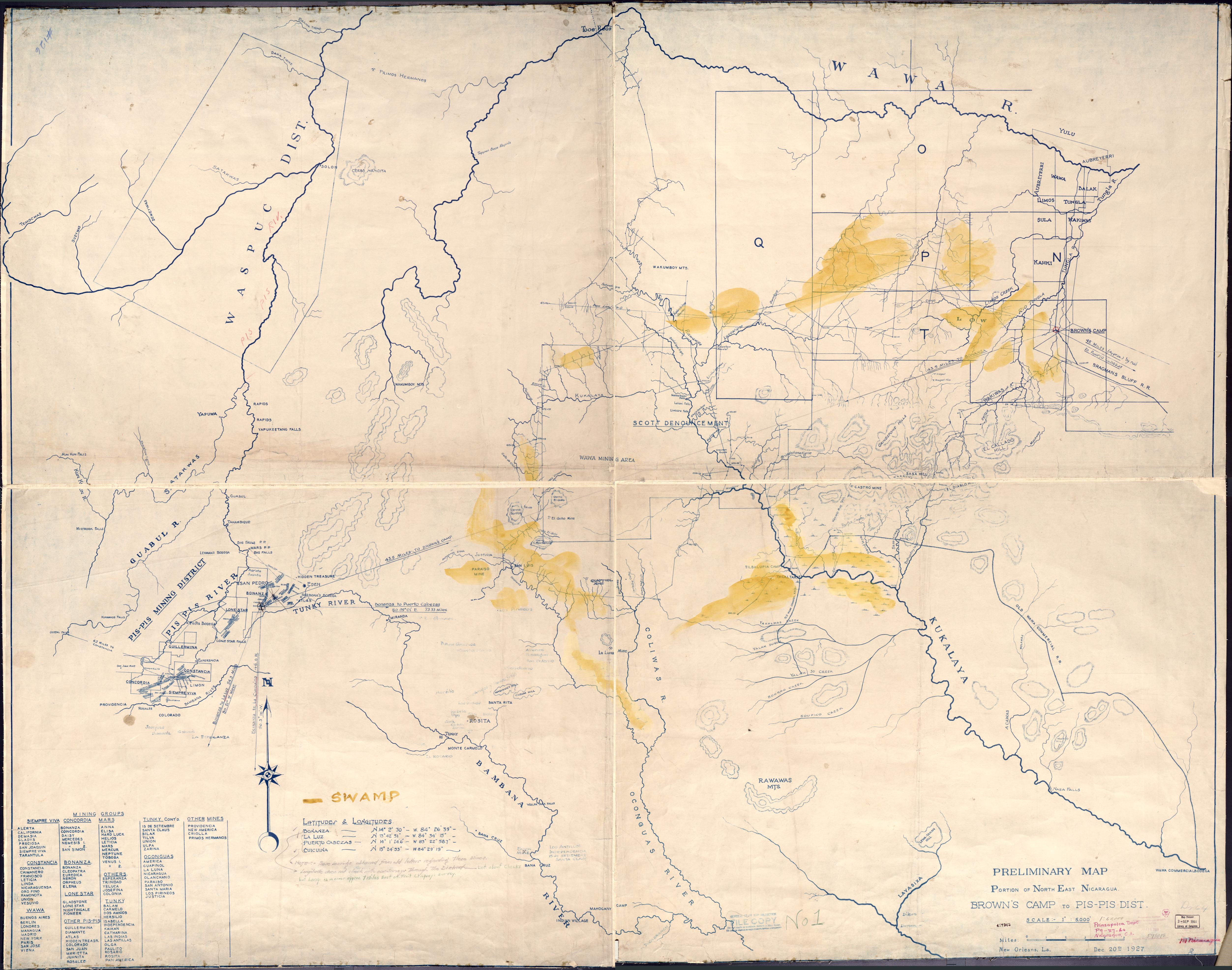
Dispossesions in the Americas

Dispossesions in the Americas

  • Home
  • Explore
  • About
  • Authors
  • Art
  • Bodies
  • Curricula
  • Cultural Heritage
  • Maps
  • Territories
Back to Explore
Map 1927

Preliminary Map;portion of north east [sic] Nicaragua: Brown's Camp to Pis Pis District.

    Published: 1927

    • Download Image

    Peoples

    • INDIAN
    • WAWA

    Citation

    Preliminary Map;portion of north east [sic] Nicaragua: Brown's Camp to Pis Pis District. New Orleans: [s.n] 1927.Library of Congress Geography and Maps Division. G4851.H1 1927 .P7. https://www.loc.gov/item/2006636639/AccessedJuly252023.

    • Download Image

    Reading in Spanish

    Map 1927

    Preliminary Map;portion of north east [sic] Nicaragua: Brown's Camp to Pis Pis District.

      Published: 1927

      • Download Image
      • Download Image

      Related Content

      Accuratissima Brasiliae Tabula

      Accuratissima Brasiliae Tabula

      Map 1600 - 1699
      Rio De La Plata, Uruguay, Southern Brazil

      Rio De La Plata, Uruguay, Southern Brazil

      Map 1720 - 1760
      REGIÓN HUASTECA

      REGIÓN HUASTECA

      Map 2000
      Boom Creek Village

      Boom Creek Village

      Map 1997
      Indigenous provinces in El Salvador around 1500. (Adapted from Fowler 1989140-141, figure 5, with additional information from Lehman 1920:719, with modifications by the author.)

      Indigenous provinces in El Salvador around 1500. (Adapted from Fowler 1989140-141, figure 5, with additional information from Lehman 1920:719, with modifications by the author.)

      Map 1500
      ITINÉRAIRES DE LA MISSION DE BRETTES Dans le Grand Chaco Septentrional (Voyage 1886, 1887-1888)

      ITINÉRAIRES DE LA MISSION DE BRETTES Dans le Grand Chaco Septentrional (Voyage 1886, 1887-1888)

      Map 1886 - 1888
      Northern Tepehuan Area, Chihuahua

      Northern Tepehuan Area, Chihuahua

      Map 1969
      CARTE DU PARAGUAY et des pays voisins sur les memoires des espagnols et des portugais et en particulier ceux des RR.PP. de la Compagnie de Jesus

      CARTE DU PARAGUAY et des pays voisins sur les memoires des espagnols et des portugais et en particulier ceux des RR.PP. de la Compagnie de Jesus

      Map 1756

      Dispossessions in the Americas

      A project by

      University of Pennsylvania

      Copyright 2024

      With support from

      Mellon Foundation

      Site design & development

      Element 84

      Art Credits

      Preliminary Map;portion of north east [sic] Nicaragua: Brown’s Camp to Pis Pis District. New Orleans: [s.n] 1927.Library of Congress Geography and Maps Division. G4851.H1 1927 .P7. https://www.loc.gov/item/2006636639/AccessedJuly252023.

      Site Pages

      • Home
      • Explore
      • About
      • Authors
      • Art
      • Bodies
      • Curricula
      • Cultural Heritage
      • Maps
      • Territories