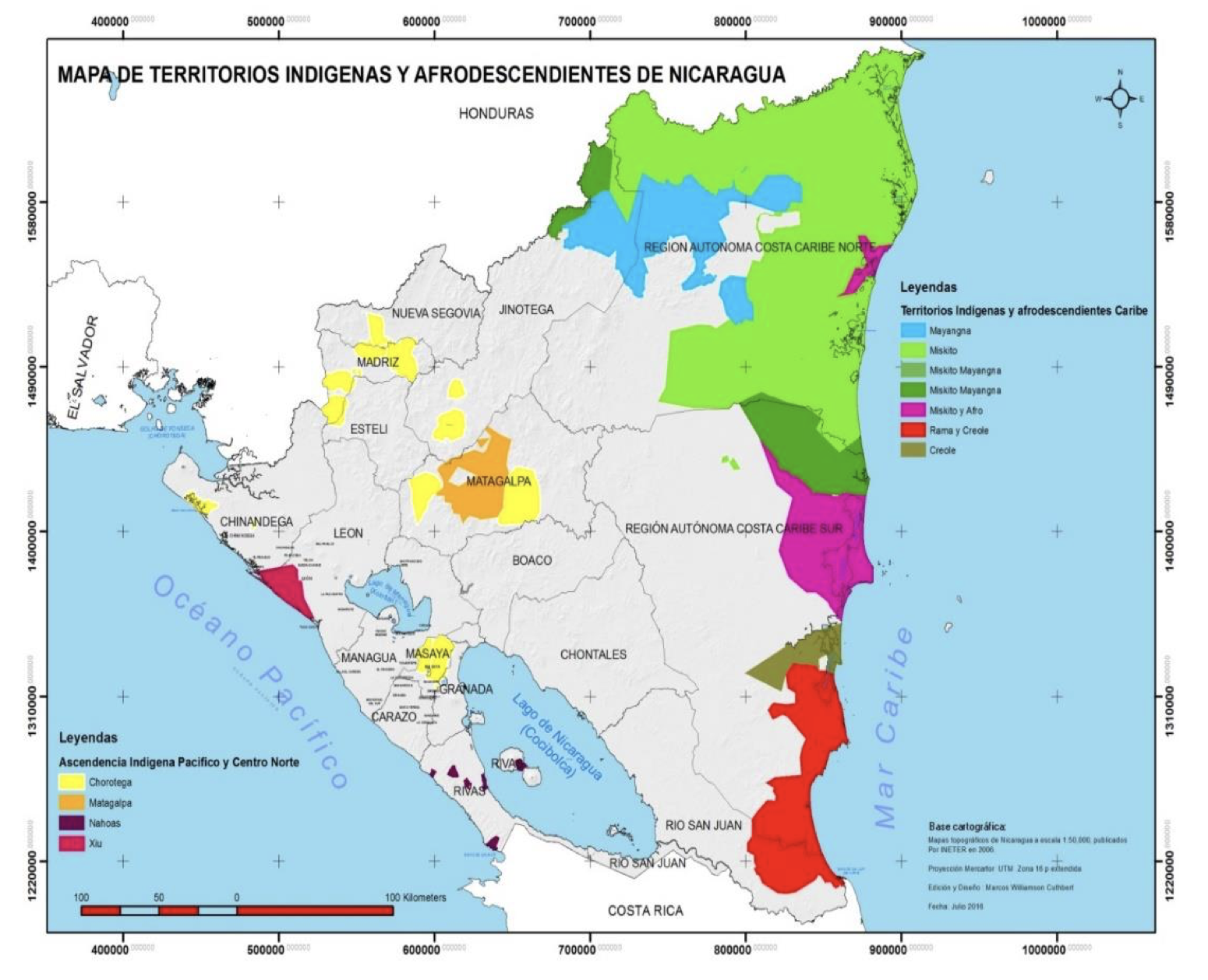
Dispossesions in the Americas

Dispossesions in the Americas

  • Home
  • Explore
  • About
  • Authors
  • Art
  • Bodies
  • Curricula
  • Cultural Heritage
  • Maps
  • Territories
Back to Explore
Map 2016

Mapa de Territorios Indigenas y Afrodescendientes de Nicaragua.

  • CUTHBERT;WILLIAMSON

Published: 2016

  • Download Image

Peoples

  • CHOROTEGA
  • MALAGALPA
  • NAHOAS
  • XIU
  • MAYANGNA
  • MISKITO
  • MISKITO MAYANGNA
  • MISKITO Y AFRO
  • RAMA Y CREOLE
  • CREOLE

Citation

Marcos Williamson Cuthbert. Mapa de Territorios Indigenas y Afrodescendientes de Nicaragua. 2016. In Marco de Planificación de Pueblos Indígenas. MARENA: Ministerio del Ambiente y Recursos Naturales.pg 8. Accessed July 11 2023. http://www.marena.gob.ni/Enderedd/wp-content/uploads/Fases/11.%20Marco%20de%20Planificacion%20de%20Pueblos%20Indigenas.pdf

  • Download Image

Reading in Spanish

Map 2016

Mapa de Territorios Indigenas y Afrodescendientes de Nicaragua.

  • CUTHBERT;WILLIAMSON

Published: 2016

  • Download Image
  • Download Image

Reading in Portuguese

Map 2016

Mapa de Territorios Indigenas y Afrodescendientes de Nicaragua.

  • CUTHBERT;WILLIAMSON

Published: 2016

  • Download Image

Peoples

  • CHOROTEGA
  • MALAGALPA
  • NAHOAS
  • XIU
  • MAYANGNA
  • MISKITO
  • MISKITO MAYANGNA
  • MISKITO Y AFRO
  • RAMA Y CREOLE
  • CREOLE

Citation

Marcos Williamson Cuthbert. Mapa de Territorios Indigenas y Afrodescendientes de Nicaragua. 2016. In Marco de Planificación de Pueblos Indígenas. MARENA: Ministerio del Ambiente y Recursos Naturales.pg 8. Accessed July 11 2023. http://www.marena.gob.ni/Enderedd/wp-content/uploads/Fases/11.%20Marco%20de%20Planificacion%20de%20Pueblos%20Indigenas.pdf

  • Download Image

Related Content

Partie de la Colombie et du Bresil. Amer. Merid. no. 9. (Dresse par Ph. Vandermaelen;lithographie par H. Ode. Cinquieme partie - Amer. merid. Bruxelles. 1827)

Partie de la Colombie et du Bresil. Amer. Merid. no. 9. (Dresse par Ph. Vandermaelen;lithographie par H. Ode. Cinquieme partie - Amer. merid. Bruxelles. 1827)

Map 1827
RELACIONES GEOGRÁFICAS DE OAXACA, TEHUANTEPEC

RELACIONES GEOGRÁFICAS DE OAXACA, TEHUANTEPEC

Map 1579 - 1585
Radicación de Comunidades Mapuche. Titulos de Comisario y Titulos de Merced

Radicación de Comunidades Mapuche. Titulos de Comisario y Titulos de Merced

Map 1884 - 1929
PLANO DEL HATO DEL TAMBO;ADJUNTO A LA ESCRITURA DE DONACIÓN QUE OTORGA PABLO CHIRIBOGA A FAVOR DE LOS INDÍGENAS DE PAPALLACTA

PLANO DEL HATO DEL TAMBO;ADJUNTO A LA ESCRITURA DE DONACIÓN QUE OTORGA PABLO CHIRIBOGA A FAVOR DE LOS INDÍGENAS DE PAPALLACTA

Map 1903
PUEBLO YAGUA

PUEBLO YAGUA

Map 2021
The Geography of Peninsular Languages

The Geography of Peninsular Languages

Map 1994
PLAN of the Isle GRANDE & the adjacent parts of the COAST of BRAZIL

PLAN of the Isle GRANDE & the adjacent parts of the COAST of BRAZIL

Map 1764
FACSIMILE: PART OF SOUTH AMERICA BY DELISLE

FACSIMILE: PART OF SOUTH AMERICA BY DELISLE

Map 1700

Dispossessions in the Americas

A project by

University of Pennsylvania

Copyright 2024

With support from

Mellon Foundation

Site design & development

Element 84

Art Credits

Marcos Williamson Cuthbert. Mapa de Territorios Indigenas y Afrodescendientes de Nicaragua. 2016. In Marco de Planificación de Pueblos Indígenas. MARENA: Ministerio del Ambiente y Recursos Naturales.pg 8. Accessed July 11 2023. http://www.marena.gob.ni/Enderedd/wp-content/uploads/Fases/11.%20Marco%20de%20Planificacion%20de%20Pueblos%20Indigenas.pdf

Site Pages

  • Home
  • Explore
  • About
  • Authors
  • Art
  • Bodies
  • Curricula
  • Cultural Heritage
  • Maps
  • Territories