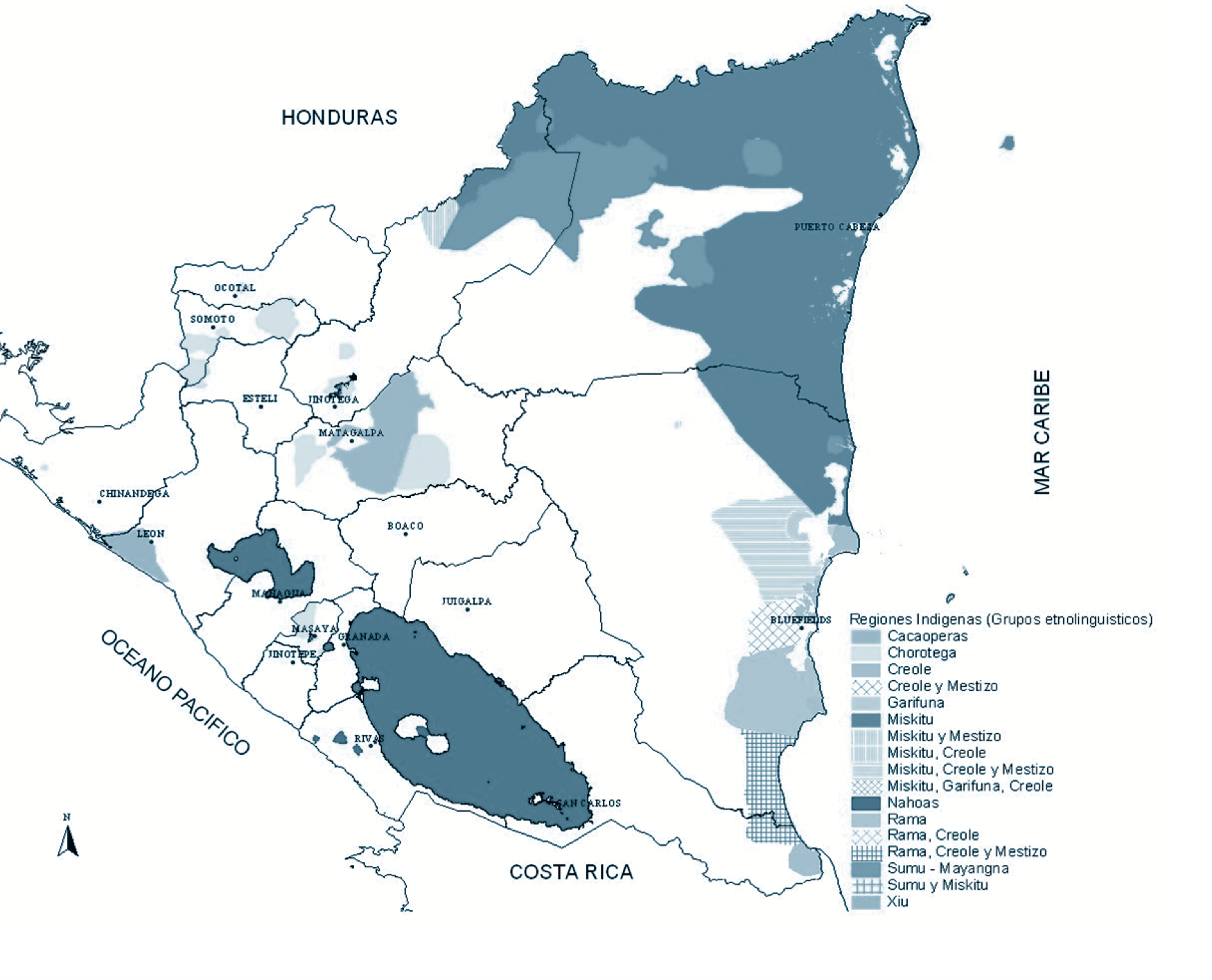
Dispossesions in the Americas

Dispossesions in the Americas

  • Home
  • Explore
  • About
  • Authors
  • Art
  • Bodies
  • Curricula
  • Cultural Heritage
  • Maps
  • Territories
Back to Explore
Map

Regiones indígenas;afrodescendientes;y mestizas de Nicaragua

    Published: 1990-2000

    • Download Image

    Peoples

    • CACAOPERAS
    • CHOROTEGA
    • CREOLE
    • CREOLE Y MESTIZO
    • GARIFUNA
    • MISKITU
    • MISKITU Y MESTIZO
    • MISKITU
    • CREOLE
    • MISKITU CREOLE Y MESTIZO
    • MISKITO GARIFUNA
    • CREOLE
    • NAHOAS
    • RAMA
    • CREOLE
    • RAMA CREOLE Y MESTIZO
    • SUMU-MAYANGNA
    • SUMU MISKITU
    • XIU

    Citation

    Regiones indígenas;afrodescendientes;y mestizas de Nicaragua. Manual de Educación Ciudadana Intercultural y Autonómica 2: Una Historia Diferente. Yuri Hamed Zapata Webb.eds Claribel Castillo and Guillermo Mclean Herrera. Pg 8. https://red.pucp.edu.pe/ridei/files/2012/09/modulo_02.pdf

    • Download Image

    Reading in Spanish

    Map

    Regiones indígenas;afrodescendientes;y mestizas de Nicaragua

      Published: 1990-2000

      • Download Image
      • Download Image

      Related Content

      Carte de la Guyane Françoise et l'Isle de Cayenne. Dressée au Dépost des Cartes et Plans de la Marine Par Ordre de M. le Duc de Choiseul Ministre de la Guerre et de la Marine.

      Carte de la Guyane Françoise et l'Isle de Cayenne. Dressée au Dépost des Cartes et Plans de la Marine Par Ordre de M. le Duc de Choiseul Ministre de la Guerre et de la Marine.

      Map 1763
      Carta de la Provincia de Buenos Ayres 1824.

      Carta de la Provincia de Buenos Ayres 1824.

      Map 1824
      No Title

      No Title

      Map -2500 - 1520
      ALIMENTOS TRADICIONALES DE LOS PUEBLOS INDÍGENAS DE PARAGUAY

      ALIMENTOS TRADICIONALES DE LOS PUEBLOS INDÍGENAS DE PARAGUAY

      Map
      ‘INDIAN ROYAL TOWNS’ (REDUCCIONES) AND SACRED SPACES UNDER SPANISH COLONIAL RULE IN THE TERRITORY OF THE PRE-COLONIAL AYMARA POLITY OF THE PAKAXA IN THE LATE 16TH CENTURY

      ‘INDIAN ROYAL TOWNS’ (REDUCCIONES) AND SACRED SPACES UNDER SPANISH COLONIAL RULE IN THE TERRITORY OF THE PRE-COLONIAL AYMARA POLITY OF THE PAKAXA IN THE LATE 16TH CENTURY

      Map 1570 - 1650
      The modern departments of Ahuachapán, La Libertad, Santa Ana, and Sonsonate (highlighted in red) now contain the highest concentration of Indigenous communities in El Salvador.

      The modern departments of Ahuachapán, La Libertad, Santa Ana, and Sonsonate (highlighted in red) now contain the highest concentration of Indigenous communities in El Salvador.

      Map 2010
      Le Paraguay

      Le Paraguay

      Map 1600 - 1700
      "Territorio Indígena Cabécar de Bajo Chrirripó"

      "Territorio Indígena Cabécar de Bajo Chrirripó"

      Map 2010

      Dispossessions in the Americas

      A project by

      University of Pennsylvania

      Copyright 2024

      With support from

      Mellon Foundation

      Site design & development

      Element 84

      Art Credits

      Regiones indígenas;afrodescendientes;y mestizas de Nicaragua. Manual de Educación Ciudadana Intercultural y Autonómica 2: Una Historia Diferente. Yuri Hamed Zapata Webb.eds Claribel Castillo and Guillermo Mclean Herrera. Pg 8. https://red.pucp.edu.pe/ridei/files/2012/09/modulo_02.pdf

      Site Pages

      • Home
      • Explore
      • About
      • Authors
      • Art
      • Bodies
      • Curricula
      • Cultural Heritage
      • Maps
      • Territories